Situation Summary
Egypt's composite threat score places it at #18 globally, with 166 tracked events and a national risk index of 69. The security environment has shifted markedly following the first confirmed drone attack on Egyptian territory on 29 July, when an unidentified unmanned aircraft struck a U.S.-owned gas storage vessel at Damietta Port, triggering a significant maritime infrastructure incident. While internal civil unrest and militant activity remain subdued, Egypt now faces elevated risk of spillover from the broader U.S.–Iran regional conflict, and fresh uncertainty regarding critical port operations and airspace security.
Key Developments
- Damietta Port drone strike (29 July, evening): An unidentified drone struck the *Energos Winter*, a U.S.-owned gas storage tanker, igniting fires that spread to a second gas vessel. No injuries were reported; Egyptian authorities confirmed the fire was drone-caused—the first such attack on Egyptian territory in the current regional conflict cycle.
- Port resumption and investigation (29–30 July): Egypt's Oil Ministry announced operations at Damietta would resume after containment; the cabinet and presidency opened a formal probe into the incident and pledged protective measures for national security infrastructure.
- Iran's diplomatic response (30 July): Iran's Foreign Minister stated Egypt's security is of "utmost importance" to Tehran and denied Iranian involvement; however, attribution remains uncertain, heightening ambiguity over potential escalation triggers.
- Maritime security implications (30 July): Ambrey and trading sources flagged the Damietta incident as a new threat to shipping routes near the Suez Canal, with updated foreign travel advisories now warning of elevated risk of airspace disruption and further security incidents.
- Matrouh rail disruptions (ongoing from 25 July): A train derailment in the Western Desert killed 3 and injured 94; recovery operations and safety checks continue to disrupt rail services in the northwestern coastal corridor and border-adjacent regions.
- Updated travel advisories (late July): Foreign governments have issued fresh warnings noting internal stability but flagging ongoing risk of terrorist attacks and sudden infrastructure disruptions linked to the U.S.–Israel–Iran conflict.
Highest-Risk Areas
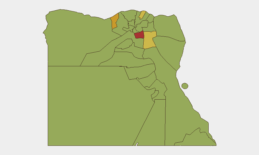
Cairo (78.4) and Alexandria (72.2) dominate the sub-national ranking, driven by their scale, concentration of assets, and historical vulnerability to security incidents. Damietta (64.7) and Suez (61.7) have escalated significantly due to the drone strike and persistent maritime chokepoint exposure; both are now critical nodes for energy infrastructure and regional conflict spillover. Upper Egypt governorates (Suhaj, Qena) maintain moderate-to-elevated baseline risk from localized militant activity and criminality, while Sinai regions (North and South) reflect chronic insurgency pressure, though no major new incidents have been reported in the last 48 hours.
How GeoBit Would Assist
Security teams with people or assets in Egypt should deploy AOI Monitoring & Early Warning on Damietta Port, Suez Canal approaches, and Cairo/Alexandria transport hubs to detect further infrastructure threats. Maritime & Aviation tracking and conflict event feeds will provide real-time alerting on vessel movements, airspace closures, and attribution signals. Routing & Network Analysis can map alternative supply and personnel transit corridors around disrupted rail lines and contested maritime zones.
7-Day Outlook
The immediate risk trajectory is upward. Attribution of the Damietta strike remains contested, increasing the probability of miscalculation or secondary strikes; Egypt's formal investigation may yield clarity or fuel regional tensions. Port operations and airspace remain operational but subject to rapid disruption. Teams should assume elevated vigilance through early August and monitor Iranian and U.S. signaling for de-escalation or further incident indicators.
Highest-Risk Areas — Ranked
| # | State / Region | Risk |
|---|---|---|
| 1 | Cairo | 78.4 |
| 2 | Alexandria | 72.2 |
| 3 | Damietta | 64.7 |
| 4 | Suez | 61.7 |
| 5 | Suhaj | 53.5 |
| 6 | Kafr El Sheikh | 50.5 |
| 7 | South Sinai | 49.2 |
| 8 | Giza | 48.8 |
| 9 | North Sinai | 48.4 |
| 10 | Qena | 48.4 |
| 11 | Red Sea | 48.4 |
| 12 | Halaib Triangle | 48.4 |
Sources
Previous Daily Briefs
A new Egypt brief is written every day — each with its own risk map and downloadable CSV. Here's the last week; use the calendar to go further back.
📅 Browse every day by calendar →
Highlighted days have a brief. Tap a day for that day's map & analysis, or “csv” for that day's dataset ($5).
Atlas — our AI intelligence desk — emails them this snapshot personally. Nothing else, no list.