Situation Summary
Equatorial Guinea remains classified as a low-threat environment globally (rank #164, composite score 5) with no discrete security incidents reported in the current monitoring window. The country's security profile is characterized by weak rule of law, arbitrary governance, and restricted civil liberties rather than active conflict or organized violence. No developments in the last 24–48 hours warrant elevated alert status.
Key Developments
No verifiable security, conflict, civil-unrest, crime, political-instability, infrastructure, or travel-risk incidents were reported in Equatorial Guinea during the last 24–48 hours (as of 2026-08-26). Credible open-source reporting for this window is absent across wire services, regional African outlets, and NGO channels.
*Note: Where events are monitored operationally by your organization, cross-verification with local networks, government travel advisories, and regional security listservs is recommended to capture real-time developments not yet surfaced in primary international feeds.*
Highest-Risk Areas
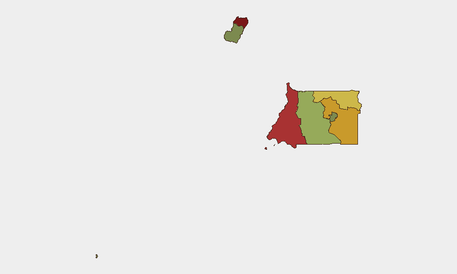
Bioko Norte (risk 85) and Litoral Province (risk 78) drive the country's composite threat ranking, reflecting concentration of economic activity, population density, and state security apparatus in and around Malabo and Bata. Wele-Nzas Province (72) and Kié-Ntem Province (68) follow, likely reflecting border proximity, limited state presence, and cross-border movement. These rankings reflect structural governance, corruption, human-rights concerns, and weak emergency/medical infrastructure rather than current violent incidents. Centro Sur, Bioko Sur, Djibloho, and Annobón carry materially lower composite scores, indicating reduced operational risk for personnel or assets in those regions.
How GeoBit Would Assist
Security teams operating in Equatorial Guinea should employ Intel Sweep and multi-language search to track regional Central African security trends and any early signals affecting the Gulf of Guinea. AOI Monitoring & Early Warning with persistent watch on Malabo, Bata, and key transport corridors enables alert-based notification if civil unrest, infrastructure disruption, or security-force activity emerges. Routing & Network Analysis supports alternative journey planning for staff movement, particularly outside major urban centers where road safety and emergency response are limited.
7-Day Outlook
No specific triggers or scheduled political/security events are flagged for the next seven days. The baseline risk profile—characterized by governance fragility, restrictions on expression, and limited state capacity—is expected to remain stable absent external shocks (e.g., regional conflict spillover, commodity-price volatility affecting oil revenue, or diplomatic incidents). Duty-of-care teams should maintain standard monitoring cadence and ensure personnel awareness of local restrictions on photography, media activity, and protest participation.
GEOBIT RECOMMENDATION: If your organization has personnel or material assets in Bioko Norte or Litoral Province, confirm current travel advisories with your government's diplomatic mission and maintain regular check-in protocols. No imminent threat is indicated, but low transparency and weak emergency response capacity remain inherent risk factors.
Highest-Risk Areas — Ranked
| # | State / Region | Risk |
|---|---|---|
| 1 | Bioko Norte | 85 |
| 2 | Litoral Province | 78 |
| 3 | Wele-Nzas Province | 72 |
| 4 | Kié-Ntem Province | 68 |
| 5 | Centro Sur Province | 45 |
| 6 | Bioko Sur | 38 |
| 7 | Djibloho | 15 |
| 8 | Annobón Province | 8 |
Sources
Previous Daily Briefs
A new Equatorial Guinea brief is written every day — each with its own risk map and downloadable CSV. Here's the last week; use the calendar to go further back.
- August 24, 2026
- August 22, 2026
- August 20, 2026
- August 18, 2026
- August 16, 2026
- August 14, 2026
- August 12, 2026
📅 Browse every day by calendar →
Highlighted days have a brief. Tap a day for that day's map & analysis, or “csv” for that day's dataset ($5).
Atlas — our AI intelligence desk — emails them this snapshot personally. Nothing else, no list.