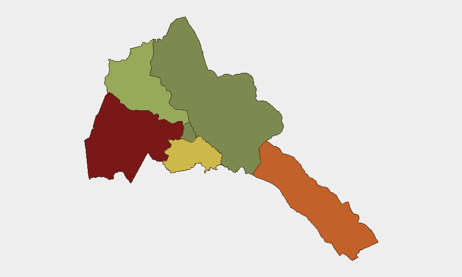
Situation Summary
Eritrea remains at moderate global risk (rank #69, composite score 24) with conflict as the primary driver, though no verified security incidents within Eritrea itself have been reported in the last 24–48 hours. Regional instability is acute: heavy fighting between the Ethiopian military and TPLF forces near the Sudan–Eritrea–Ethiopia border triangle (ongoing since 1–2 August) has prompted visible Eritrean military mobilization into northern Ethiopia, signaling direct involvement in the renewed Tigray conflict. Border areas remain tense, Sudan's border closure continues due to regional war, and Red Sea transit risks persist from Houthi activity.
Key Developments
- 2026-08-06 · Eritrean military deployment into Tigray. Eritrean tanks and heavy weapons confirmed deployed into northern Ethiopia's Tigray region in coordination with renewed Ethiopian military operations; no direct engagement inside Eritrea reported.
- 2026-08-03 · Eritrean command presence in Zalambesa. Senior Eritrean military commanders crossed into Ethiopian territory and entered the border town of Zalambesa in a publicized show of force, underscoring Eritrea's active military posture in the conflict.
- 2026-08-02 & 2026-08-01 · Border-triangle fighting escalation. Heavy clashes between Ethiopian army and TPLF forces near the Sudan–Eritrea–Ethiopia border junction involving drones, artillery, and mechanized units; Eritrea not directly engaged but positioned adjacent to active combat.
- No confirmed new incidents inside Eritrea (last 24–48 hours). Web research and regional feeds yielded no independently verified security, instability, or civilian-impact events within Eritrean territory as of 2026-08-09.
- Regional travel warnings remain active. German Foreign Office and regional sources continue to flag Eritrea's border zones (especially with Ethiopia and Djibouti) as elevated-risk; Sudan border closure and Red Sea maritime threats (Houthi attacks) remain in effect.
Highest-Risk Areas
Gash-Barka (score 92) and Southern Red Sea Region (score 75) dominate sub-national risk, both driven by direct proximity to active Ethiopian–TPLF fighting and cross-border military movement. Debub Region (68) faces secondary exposure from broader conflict spillover and potential displacement. Anseba (55) remains moderately elevated due to historical tension zones. Maekel Region (18), including the capital Asmara, and Northern Red Sea Region (0) show minimal active risk but remain subject to rapid change if the Ethiopia–Sudan–Eritrea border fighting expands. Northern and western border areas are the principal concern for corporate and expatriate presence.
How GeoBit Would Assist
Security teams should employ AOI Monitoring & Early Warning on Gash-Barka and Southern Red Sea Region to detect cross-border military movements, displacement events, or new clashes in near-real time. Battle Mapping, Force Structure, and Weapons-Capability Tracking will clarify the scope and direction of Eritrean military involvement in the Tigray conflict and forecast spillover risk. Routing & Network Analysis can identify safe transit corridors and alternative movement plans for personnel and assets in higher-risk zones, while Sentiment & Temporal Analysis on regional social media and news feeds will flag emerging instability signals earlier than traditional reporting.
7-Day Outlook
The Ethiopia–TPLF fighting is likely to remain intense along the border, with Eritrean military presence expected to continue or deepen. Unless major new clashes erupt inside Eritrea proper, the internal security picture should remain stable, but border zones will remain volatile and transit-dependent. Corporate teams should maintain heightened awareness of Eritrean military announcements and external reporting on cross-border activity; any shift toward direct Eritrean–Ethiopian escalation or internal military mobilization would sharply elevate risk.
Highest-Risk Areas — Ranked
| # | State / Region | Risk |
|---|---|---|
| 1 | Gash-Barka | 92 |
| 2 | Southern Red Sea Region | 75 |
| 3 | Debub Region | 68 |
| 4 | Anseba | 55 |
| 5 | Maekel Region | 18 |
| 6 | Northen Red Sea Region | 0 |
Sources
Previous Daily Briefs
A new Eritrea brief is written every day — each with its own risk map and downloadable CSV. Here's the last week; use the calendar to go further back.
📅 Browse every day by calendar →
Highlighted days have a brief. Tap a day for that day's map & analysis, or “csv” for that day's dataset ($5).
Atlas — our AI intelligence desk — emails them this snapshot personally. Nothing else, no list.