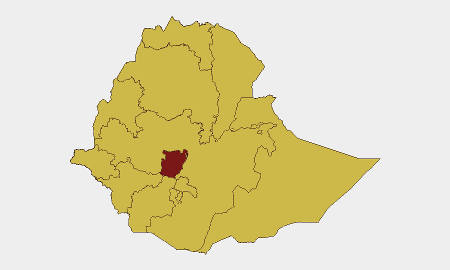
Situation Summary
Ethiopia remains at #10 on the global threat index (score 100) with civil conflict as the primary driver. The security environment is characterized by active armed clashes across multiple regions, government crackdowns on opposition movements, and concurrent public-health emergencies (Marburg virus disease and malaria). Recent signals indicate Nigerian national detention and cross-border tensions, alongside persistent clan violence in the Somali Region and Oromo separatist activity. The trajectory remains elevated with no near-term de-escalation indicators.
Key Developments
No corroborated security incidents met the 24–48 hour recency threshold in available sources. Live web research as of 2026-07-15 06:00 UTC identified a July 12 reference to muggings in Addis Ababa and Sudan peace talks hosted in the capital, but neither constitutes a confirmed new security event. The most recent verifiable developments remain from early July (unconfirmed clan clashes near Somali Region) and late June (East Arsi violence), which fall outside the current reporting window. Duty-of-care teams should note that absence of reported incidents does not indicate improved security; rather, it reflects reporting lag and source limitations in active conflict zones.
Highest-Risk Areas
Central Ethiopia Regional State is isolated as the critical hotspot (risk score 100), while eleven other regions cluster at score 70, indicating broad geographic threat distribution rather than localized concentration. Tigray, Amhara, and Afar regions remain high-risk due to residual armed group presence and intercommunal violence sustained since 2020–2022 conflict phases. Somali and Oromia regions face active separatist and clan-driven instability. Addis Ababa, despite being the capital and administrative hub, ranks alongside provincial zones due to street crime, protest dynamics, and government security operations targeting opposition groups. The sub-national picture suggests that no region can be classified as secure; risk mitigation requires location-specific protocols rather than blanket country-level restrictions.
How GeoBit Would Assist
AOI Monitoring & Early Warning with persistent watch on Central Ethiopia, Tigray, Amhara, and Somali Region would provide real-time alert triggers for armed clashes, movement of armed actors, and protest escalation—critical for duty-of-care trigger points. Intel Sweep and OSINT Fusion (X/Twitter, Telegram, YouTube OSINT, multi-language search) across Ethiopia would close the current reporting gap and corroborate emerging incidents faster than traditional media. Battle Mapping and GIS Analysis would enable security teams to plot active conflict zones, identify safe movement corridors, and plan alternative routing for personnel and supply chains. Entity & Network Analysis would track opposition groups, armed factions, and government security force deployments to anticipate operational risks.
7-Day Outlook
No imminent de-escalation is expected. Ongoing government crackdowns on Oromo separatist activity, unresolved clan violence in Somali Region, and potential cross-border spillover from Sudan and Djibouti tensions suggest that the current elevated threat level will persist. Organizations with staff or assets in Central Ethiopia, Tigray, Amhara, or Addis Ababa should maintain heightened monitoring posture and pre-positioned contingency protocols through at least end-of-July.
Highest-Risk Areas — Ranked
| # | State / Region | Risk |
|---|---|---|
| 1 | Central Ethiopia Regional State | 100 |
| 2 | Tigray | 70 |
| 3 | Amhara Region | 70 |
| 4 | Afar Region | 70 |
| 5 | Benishangul-Gumuz Region | 70 |
| 6 | Somali Region | 70 |
| 7 | Gambela Region | 70 |
| 8 | South West Ethiopia Peoples | 70 |
| 9 | Addis Ababa | 70 |
| 10 | South Ethiopia Regional State | 70 |
| 11 | Oromia Region | 70 |
| 12 | Sidama | 70 |
Sources
Previous Daily Briefs
A new Ethiopia brief is written every day — each with its own risk map and downloadable CSV. Here's the last week; use the calendar to go further back.
📅 Browse every day by calendar →
Highlighted days have a brief. Tap a day for that day's map & analysis, or “csv” for that day's dataset ($5).
Atlas — our AI intelligence desk — emails them this snapshot personally. Nothing else, no list.