Situation Summary
Gabon remains a low-threat environment globally (rank #119, composite score 11) with no active armed conflict, terrorism campaigns, or widespread civil unrest. Current security posture is stable; the primary near-term operational constraint is administrative rather than security-driven. Independence Day ceremonies on 17 August have generated temporary traffic restrictions in the capital but no indicators of protest activity, communal violence, or organized disruption.
Key Developments
- Libreville, 16–17 August 2026: National authorities implemented temporary road closures and traffic restrictions across central Libreville in support of independence-day military parade and ceremonies. Affected routes include Boulevard Triomphal, Boulevard de l'Indépendance, Mausolée Léon Mba sector, Batterie 4, PK0, and CHU Fondation Jeanne Ebori. International delegations, including Uganda, arrived for official celebrations. Restrictions expected to ease by evening of 17 August.
- No new security incidents, conflict events, or crime spikes confirmed in the last 24–48 hours across monitored regions. Existing sub-national risk concentrations (Woleu-Ntem, Ogooué-Lolo, Ngounié) remain stable with no new triggering events reported.
Highest-Risk Areas
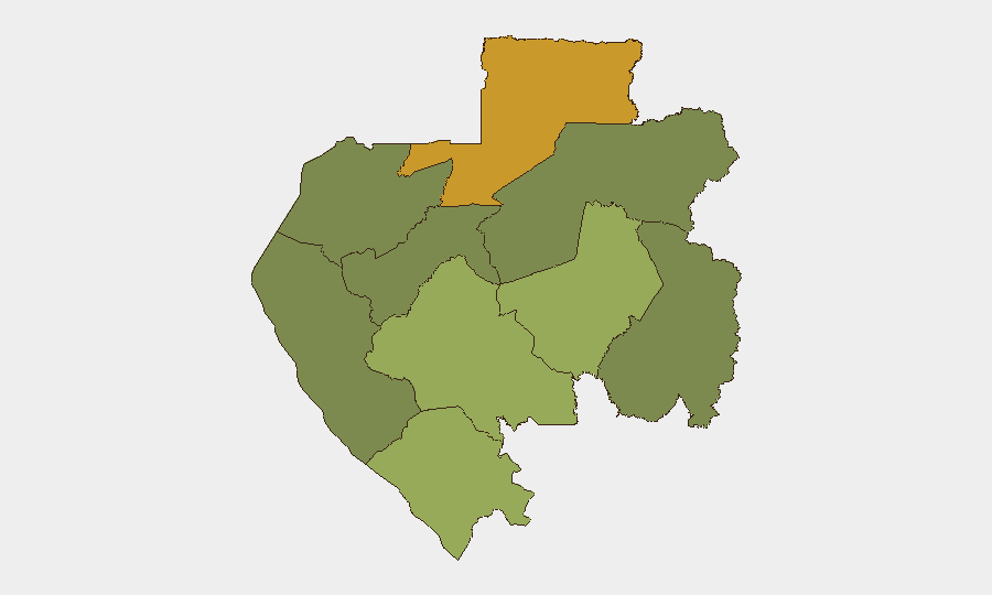
Woleu-Ntem Province (risk score 72) and Ogooué-Lolo Province (risk 58) account for the majority of sub-national risk exposure, followed by Ngounié (48) and Nyanya (42). These northern and interior regions reflect historical trafficking activity, border-proximity factors, and limited state administrative presence rather than active conflict. Estuaire Province, where Libreville and the capital infrastructure are concentrated, carries substantially lower risk (15), consistent with security-force density and economic centrality. The capital remains the safest operating environment in the country.
How GeoBit Would Assist
Teams with personnel or assets in Gabon should employ AOI Monitoring & Early Warning for persistent watch on Woleu-Ntem and Ogooué-Lolo, with alerting configured for trafficking indicators, border-crossing anomalies, and civil-order disruptions. Multi-language OSINT and sentiment analysis (Intel Sweep, X/Twitter, Telegram) provides real-time situational awareness of emerging unrest, official announcements, and community-level developments. Routing & Network Analysis supports alternative journey planning around administrative closures (such as today's parade restrictions) and identifies safe corridors in higher-risk provinces during duty-of-care operations.
7-Day Outlook
Independence Day festivities conclude 17 August with normalization of traffic and movement expected within 24 hours. No security alerts, protest notifications, or instability indicators are present in the forecast window. Risk profile is expected to remain unchanged (low, stable) through 24 August barring external shocks or unforeseen border incidents in the far north.
Highest-Risk Areas — Ranked
| # | State / Region | Risk |
|---|---|---|
| 1 | Woleu-Ntem | 72 |
| 2 | Ogooué-Lolo Province | 58 |
| 3 | Ngounié Province | 48 |
| 4 | Nyanga Province | 42 |
| 5 | Haut-Ogooué Province | 35 |
| 6 | Moyen-Ogooué Province | 28 |
| 7 | Ogooué-Maritime Province | 25 |
| 8 | Estuaire Province | 15 |
| 9 | Ogooué-Ivindo | 0 |
Sources
Previous Daily Briefs
A new Gabon brief is written every day — each with its own risk map and downloadable CSV. Here's the last week; use the calendar to go further back.
- August 15, 2026
- August 13, 2026
- August 11, 2026
- August 9, 2026
- August 8, 2026
- August 6, 2026
- August 5, 2026
📅 Browse every day by calendar →
Highlighted days have a brief. Tap a day for that day's map & analysis, or “csv” for that day's dataset ($5).
Atlas — our AI intelligence desk — emails them this snapshot personally. Nothing else, no list.