Situation Summary
Iran faces an acute, escalating security crisis following a sequence of maritime attacks and retaliatory strikes between June 25–28, 2026. U.S. Central Command has conducted multiple rounds of airstrikes on Iranian military infrastructure in response to Iranian Revolutionary Guard Corps (IRGC) attacks on commercial shipping in the Strait of Hormuz and a reported drone strike on Bahrain. The security environment is volatile and fragile; ceasefire discussions are ongoing but could collapse if either side perceives further provocation.
Key Developments
- Strait of Hormuz, off Oman coast (June 26–27, 2026): A Singapore-flagged commercial vessel was struck by an unidentified projectile; U.S. officials attributed the attack to IRGC action. U.K. Maritime Trade Operations confirmed the incident, signaling disruption to regional shipping traffic.
- Iranian military sites, countrywide (June 27–28, 2026): U.S. Central Command conducted multiple retaliatory airstrikes targeting Iranian missile and drone storage facilities, coastal radar, air-defense systems, communication infrastructure, and minelayer capabilities. Strikes continued into Sunday local time.
- Bahrain (June 27, 2026): Iranian drones struck targets within Bahrain; the IRGC publicly framed the attack as targeting U.S. military positions. Bahrain's government confirmed the incident.
- Iranian airspace (June 26–27, 2026): U.S. warplanes breached Iranian airspace twice in 48 hours near the Strait of Hormuz to counter threats to shipping and eliminate Iranian air-defense systems.
- Countrywide travel disruption (June 27–28, 2026): Canada reiterated an "avoid all travel" advisory for Iran; flight cancellations and ground movement disruptions are expected as military activity continues.
Highest-Risk Areas
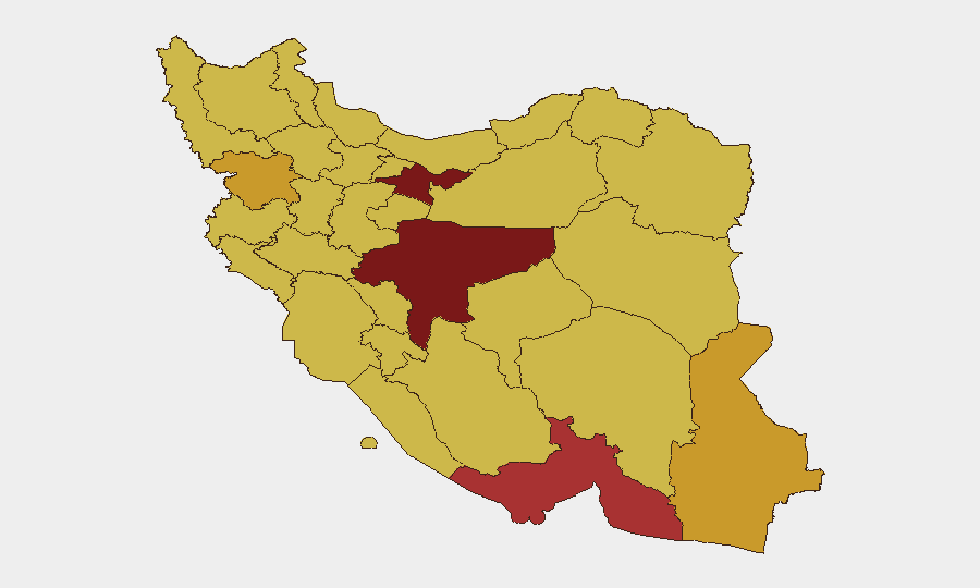
Tehran Province (risk 100) and Isfahan Province (risk 93.9) carry the highest composite risk scores, reflecting concentration of government, military, and strategic infrastructure in these zones. Tehran's status as the capital and center of command-and-control decisions makes it a focal point for both political volatility and military targeting. Isfahan, home to critical industrial and nuclear-related facilities, poses elevated risk from both conventional military action and secondary effects of broader conflict escalation. Southern coastal provinces—Hormozgan (77.6), Bushehr (70.6), and Khuzestan (70.2)—face acute maritime and military threat due to proximity to the Strait of Hormuz and forward-deployed Iranian naval and IRGC assets; these regions are also primary zones of U.S. strike activity. Eastern border regions (Sistan and Baluchestan, 71.3; Kurdistan, 71) remain high-risk due to ongoing insurgent activity independent of the current Iran-U.S. tension.
How GeoBit Would Assist
Security and duty-of-care teams should prioritize AOI Monitoring & Early Warning on Tehran, Isfahan, and Hormozgan provinces to detect movement of military assets, air-defense activations, and strike indicators with minimal latency. Maritime & Aviation tracking combined with Conflict & Military force-structure analysis provides real-time visibility of shipping disruption, airspace closures, and Iranian military response patterns. Routing & Network Analysis enables contingency planning for personnel evacuation or supply-chain rerouting away from high-threat corridors, particularly the Strait of Hormuz and approaches to major airports.
7-Day Outlook
Kinetic activity is likely to persist or resume within 7 days unless diplomatic channels produce a de-escalation agreement; further Iranian attacks on shipping or U.S. positions would trigger additional U.S. strikes. Commercial air and maritime traffic through Iranian airspace and the Strait of Hormuz will remain severely constrained. Organizations with personnel or assets in Iran should assume continuity-of-operations disruption and prepare for rapid evacuation scenarios.
Highest-Risk Areas — Ranked
| # | State / Region | Risk |
|---|---|---|
| 1 | Tehran Province | 100 |
| 2 | Isfahan Province | 93.9 |
| 3 | Hormozgan Province | 77.6 |
| 4 | Sistan and Baluchestan Province | 71.3 |
| 5 | Kurdistan Province | 71 |
| 6 | Bushehr Province | 70.6 |
| 7 | Ilam Province | 70.5 |
| 8 | Fars Province | 70.5 |
| 9 | Gilan Province | 70.5 |
| 10 | East Azerbaijan Province | 70.4 |
| 11 | Khuzestan Province | 70.2 |
| 12 | Kohgiluye and Buyer Ahmad Province | 70.1 |
Sources
Previous Daily Briefs
A new Iran brief is written every day — each with its own risk map and downloadable CSV. Here's the last week; use the calendar to go further back.
📅 Browse every day by calendar →
Highlighted days have a brief. Tap a day for that day's map & analysis, or “csv” for that day's dataset ($5).