Situation Summary
Iraq remains at elevated composite threat level (rank 17 globally, score 92) with 459 tracked events, driven by persistent ISIS cell activity, inter-communal tensions, and armed-group operations across multiple governorates. The past 48 hours have seen a cluster of kinetic incidents—including IED attacks on Iraqi Army convoys, ISIS-claimed checkpoint assaults, and tribal gunfire—concentrated in Baghdad, Anbar, Nineveh, and Diyala. While individual incidents remain localized and Iraqi security forces are conducting active counter-operations, the frequency and geographic distribution of attacks suggest sustained militant capability and a security environment that remains fragile despite ongoing government counter-terrorism efforts.
Key Developments
- Baghdad, 2 July: Twin IED attacks on an Iraqi Army convoy near Yusufiyah on the southern outskirts; multiple soldiers wounded, at least one Humvee damaged; incident confirmed by Iraqi security media.
- Mosul (Nineveh), 2 July: ISIS-claimed small-arms attack on a Federal Police checkpoint in western Mosul; one police officer killed, others wounded; pro-ISIS channels claimed responsibility; nearby roads temporarily closed during security response.
- Kirkuk, 2 July: Security forces clashed with protesters demonstrating against the removal of an Arab district official; live rounds and tear gas deployed; minor injuries reported; burning tires and blocked roads documented by local media.
- Basra, 2 July: Tribal dispute escalated into armed shooting near a residential compound housing oil-sector workers in northern Basra; automatic gunfire reported, one person wounded; movement restrictions imposed but oil production unaffected.
- Diyala, 1 July: Roadside bomb detonated against a civilian vehicle on a rural road near Khanaqin; at least two occupants injured; incident assessed as likely ISIS-linked; follow-on search operations conducted in surrounding villages.
- Fallujah (Anbar), 2 July: Iraqi security forces dismantled part of a drug-trafficking network; multiple arrests and seizure of narcotics and weapons across two separate operations per Interior Ministry statements.
- Sulaymaniyah (KRI), 1 July: Asayish detained a man described as PKK-linked; heightened checkpoints deployed on roads toward Dukan and the airport; extensive vehicle searches reported, no clashes.
- Baghdad, 1 July: Anti-government sit-in near Green Zone entrance protesting corruption and power outages; riot-police deployment and concrete barriers deployed; brief traffic disruptions, no serious violence.
Highest-Risk Areas
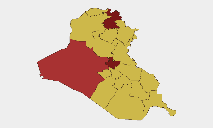
Baghdad Governorate (94.6) remains the primary flashpoint, combining militant IED capability, tribal tensions, and political instability. Erbil (81.1) and Al-Anbar (79.1) follow, reflecting ISIS remnant activity in rural and urban margins, PKK cross-border pressure in the north, and inter-governorate security vacuums. Kirkuk's ranking (65.5) reflects ethnic and administrative tensions that can rapidly escalate into armed clashes, as demonstrated by 2 July protests. Southern governorates (Basra, Wasit, Dhi Qar) score consistently at 64–65, driven by tribal violence, smuggling networks, and localized militia activity rather than organized militant campaigns.
How GeoBit Would Assist
Corporate security teams should employ AOI Monitoring & Early Warning on high-risk governorates (Baghdad, Anbar, Nineveh, Kirkuk) with persistent watch for IED, shooting, and protest signals. OSINT fusion (X/Telegram feeds, local media, security blogs) provides real-time incident corroboration and enables rapid on-the-ground incident confirmation. Network & Actor Analysis and conflict mapping support identification of militant cell behavior, tribal conflict zones, and safe transit corridors for personnel and asset movements.
7-Day Outlook
ISIS cells are likely to sustain low-intensity attacks on security forces and infrastructure, particularly in Baghdad's southern approaches and Anbar's rural corridors. Kirkuk tensions may remain elevated pending political resolution of the district-official removal. No major strategic escalation is assessed, but localized incidents will continue; duty-of-care teams should maintain heightened alert posture in Baghdad and Anbar and monitor Kirkuk for further ethnic flare-ups.
Highest-Risk Areas — Ranked
| # | State / Region | Risk |
|---|---|---|
| 1 | Baghdad Governorate | 94.6 |
| 2 | Erbil Governorate | 81.1 |
| 3 | Al-Anbar Governorate | 79.1 |
| 4 | Karbala | 69.9 |
| 5 | Kirkuk Governorate | 65.5 |
| 6 | Sulaymaniyah Governorate | 65.5 |
| 7 | Wasit Governorate | 65.3 |
| 8 | Babil Governorate | 64.6 |
| 9 | Al-Qadisiyah Governorate | 64.6 |
| 10 | Dhi Qar Governorate | 64.6 |
| 11 | Al-Muthanna Governorate | 64.6 |
| 12 | Maysan Governorate | 64.6 |
Sources
Previous Daily Briefs
A new Iraq brief is written every day — each with its own risk map and downloadable CSV. Here's the last week; use the calendar to go further back.
📅 Browse every day by calendar →
Highlighted days have a brief. Tap a day for that day's map & analysis, or “csv” for that day's dataset ($5).