Situation Summary
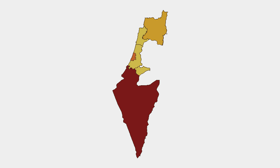
Israel remains at composite threat level #5 globally, driven by active warfare across multiple fronts and ongoing counter-terrorism operations. The past 48 hours show sustained cross-border rocket and drone fire from southern Lebanon, active violence in the West Bank, and heightened civil-defense measures in northern communities. The security environment remains fluid, with elevated risk concentrated in the South District (rank 100) and dispersed across northern, central, and Jerusalem regions.
Key Developments
- Southern Lebanon border – ongoing through July 7: IDF reports continued rocket and suspected aerial attacks from southern Lebanon against Israeli forces, with active interception operations. One IDF combatant was seriously injured by an explosive drone strike; medical evacuation was executed. *Implication: High-intensity cross-border fire persists; elevated risk to personnel and civilian communities near the frontier.*
- Beit Ummar, West Bank – early July 2026: Israeli security forces apprehended a suspect following an attempted vehicle-ramming attack near Beit Ummar in the Judea and Samaria Division. *Implication: Continued hostile activity on West Bank transportation corridors.*
- Hebron – early July 2026: Israel Police arrested two illegal residents from Hebron; one is suspected of actively planning a terror attack. *Implication: Ongoing counter-terrorism operations targeting urban-based planning cells.*
- Northern Israel civil defense – effective July 3–4, 2026 ("Thursday at 4 PM"): The IDF extended "defense times" (shelter-access requirements) in 49 northern communities, indicating heightened expectation of incoming fire or cross-border attack. *Implication: Civilian mobility and operational safety in the North District will be further constrained.*
- Al Jazeera blockade and sanctions – July 7, 2026: Al Jazeera faced administrative sanctions, and a blockade order was issued against the broadcaster in relation to coverage or alleged conduct. A separate admin-sanctions action targeted individual "Abu Salem." *Implication: Media environment remains contested; freedom-of-movement and reporting constraints may affect situational awareness.*
- Conventional military activity in Jerusalem – July 7, 2026: Reported deployment of conventional military force in Jerusalem District. *Implication: Central security posture elevated; civilian and commercial activity may be affected.*
Highest-Risk Areas
The South District (risk 100) remains the primary danger zone, reflecting sustained rocket and drone fire from Gaza and ongoing ground operations. Tel Aviv District (73.7) and North District (71.2) follow closely, with the North driven by Lebanon-border hostilities and the South's escalation of civil-defense measures signaling acute threat perception. Jerusalem, Haifa, and Center Districts score 70, indicating distributed risk across population and economic centers; counter-terrorism operations in the West Bank (Judea and Samaria) are active contributors. Organizations with personnel or assets in the South and North should assume elevated operational risk and restricted movement.
How GeoBit Would Assist
Security teams should deploy AOI Monitoring & Early Warning on high-risk districts (South, North, Tel Aviv) with persistent alerting on rocket/drone activity and cross-border fire patterns. Intel Sweep (global event feeds, X/Telegram OSINT, multi-language search) provides real-time tactical updates on arrests, military deployments, and blockade enforcement. GIS & Spatial Analysis combined with Routing & Network Analysis enables identification of safe corridors and shelter-access zones as civil-defense measures expand in the North.
7-Day Outlook
Cross-border fire from Lebanon is likely to persist through the week absent diplomatic intervention; northern community restrictions will remain in effect. Counter-terrorism arrests and West Bank vehicle-attack attempts suggest sustained hostile planning; security force responses will continue. No near-term de-escalation signals are evident; duty-of-care teams should maintain elevated alert status and contingency staffing for South and North Districts.
Highest-Risk Areas — Ranked
| # | State / Region | Risk |
|---|---|---|
| 1 | South District | 100 |
| 2 | Tel-Aviv District | 73.7 |
| 3 | North District | 71.2 |
| 4 | Haifa District | 70 |
| 5 | Center District | 70 |
| 6 | Jerusalem District | 70 |
Sources
Previous Daily Briefs
A new Israel brief is written every day — each with its own risk map and downloadable CSV. Here's the last week; use the calendar to go further back.
📅 Browse every day by calendar →
Highlighted days have a brief. Tap a day for that day's map & analysis, or “csv” for that day's dataset ($5).
Atlas — our AI intelligence desk — emails them this snapshot personally. Nothing else, no list.