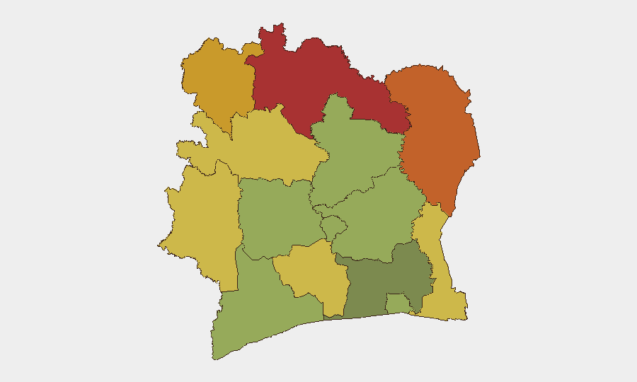
Situation Summary
Ivory Coast maintains a composite global threat ranking of #83 (score 15) with 7 tracked events as of 28 July 2026. National security authorities report the overall situation as "globalement stable," with documented decreases in home invasions, commercial burglaries, and highway banditry since late July. However, persistent concerns remain around targeted assassinations, vehicle theft, and fatal road accidents, particularly on high-traffic corridors in the north and interior regions.
Key Developments
- 28 July 2026 — Public statement by BARA directed at Ivory Coast government; context and scope require further corroboration.
- 26 July 2026 — Public statement from Japanese entity; specific relevance to Ivory Coast security posture under review.
- 26 July 2026 — Rejection event attributed to Ivorian actor vs. presidential authority; content and implications pending verification.
- 24 July 2026 — National Security Council (CNS) reaffirmed stable security environment with noted reductions in burglary, business attacks, and banditry; simultaneous acknowledgment that assassinations, vehicle theft, and serious traffic fatalities remain policy priorities.
- 24 July 2026 — CNS issued directive for enhanced road-safety enforcement following fatal incidents on Niakara-Katiola and Touba-Biankouma corridors; indicates ongoing vulnerability on northern transport routes.
*Note: Web research from the last 48 hours did not surface additional discrete security incidents. Situation assessment relies on government security summaries dated 23–24 July and three unverified event signals.*
Highest-Risk Areas
The northern and interior districts drive Ivory Coast's internal risk profile. Savanes District (78), Zanzan (75), Denguélé (72), and Comoé (70) represent the highest composite threats, likely reflecting sparse security infrastructure, porous borders, and distance from central authority in Abidjan. Montagnes, Woroba, and Gôh-Djiboua districts (68, 65, 60 respectively) form a secondary tier of concern. By contrast, Abidjan (45) and southern coastal zones register substantially lower risk, though urban crime categories (theft, armed robbery, organized crime) warrant standard precautions for personnel and assets in the capital.
How GeoBit Would Assist
Security teams should deploy AOI Monitoring & Early Warning on high-risk districts (Savanes, Zanzan, Denguélé) to detect shifts in event frequency or type before they escalate. Intel Sweep and X/Twitter & Telegram OSINT enable real-time tracking of government statements, actor communications, and grassroots sentiment across French and local languages—critical for early detection of political rejection events or organized activity. Routing & Network Analysis helps operations teams identify safer transit corridors and avoid the Niakara-Katiola and Touba-Biankouma routes during high-risk periods, directly supporting duty-of-care for personnel movement.
7-Day Outlook
No imminent destabilization is signaled by current data. The broad security posture remains stable through early August, though three unverified event signals (BARA statement, Japanese statement, and presidential rejection) require continued monitoring to rule out emerging friction. Road safety incidents and assassination attempts will likely persist as localized, non-systemic threats; however, escalation of any of the three unresolved signals could rapidly alter the picture in the northern tier.
Highest-Risk Areas — Ranked
| # | State / Region | Risk |
|---|---|---|
| 1 | Savanes District | 78 |
| 2 | Zanzan District | 75 |
| 3 | Denguélé District | 72 |
| 4 | Comoé District | 70 |
| 5 | Montagnes District | 68 |
| 6 | Woroba District | 65 |
| 7 | Gôh-Djiboua District | 60 |
| 8 | Sassandra-Marahoué District | 58 |
| 9 | Vallée du Bandama District | 55 |
| 10 | Bas-Sassandra District | 52 |
| 11 | Lacs District | 48 |
| 12 | Abidjan | 45 |
Sources
Previous Daily Briefs
A new Ivory Coast brief is written every day — each with its own risk map and downloadable CSV. Here's the last week; use the calendar to go further back.
📅 Browse every day by calendar →
Highlighted days have a brief. Tap a day for that day's map & analysis, or “csv” for that day's dataset ($5).
Atlas — our AI intelligence desk — emails them this snapshot personally. Nothing else, no list.