Situation Summary
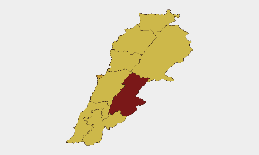
Lebanon remains at elevated risk (composite threat score 93, #15 globally) amid active Israeli-Hezbollah confrontations in the south, despite a newly announced framework agreement between Israel and Lebanon. Cross-border drone strikes, artillery activity, and ground clashes are ongoing as of 3–4 July, with political demands and military rejections indicating internal instability alongside external pressure. The Beqaa Governorate presents the highest sub-national risk (95.2), followed by Beirut (71.6), reflecting both militant infrastructure concentration and urban population density.
Key Developments
- Israeli drone strike near Marjayoun, South Governorate – 3 July 2026: An Israeli drone struck a civilian vehicle on the Kali Road, killing at least one person and injuring others, per Lebanon's Health Ministry and local media.
- Second drone strike, southern Lebanon – 3 July 2026: A separate Israeli drone strike wounded two people in a vehicle in the south, part of a pattern of airstrikes despite ongoing diplomatic framework talks.
- Israeli strikes near hospital, home demolitions – South Governorate – 2–3 July 2026: Anadolu Agency reported strikes near a hospital and demolished residential structures in southern Lebanon on the night of 2 July, undercutting ceasefire credibility.
- Israeli soldier injured in clashes – South Governorate – 3 July 2026: The Israeli army confirmed one soldier was injured during clashes on 3 July, indicating sustained low-intensity ground confrontation.
- Israeli military discovers Hezbollah infrastructure – South Governorate – 2 July 2026: The Israeli army announced discovery of underground Hezbollah facilities and launch sites following the framework agreement announcement.
- Prime Minister rejection of military demands – National – 3 July 2026: Lebanon's Prime Minister rejected internal military demands, signaling friction over response to Israeli operations and domestic security posture.
- Syria–Lebanon joint ministerial committee – Beirut/Damascus – 3 July 2026: Syria and Lebanon established a joint committee on security and economic cooperation, expanding cross-border coordination with potential implications for border control and regional alignment.
- Fuel price decline – Nationwide – 3 July 2026: Gasoline and diesel prices fell, reducing operating costs for transport and logistics but indicating continued economic volatility.
Highest-Risk Areas
The Beqaa Governorate (95.2) dominates risk due to documented Hezbollah military infrastructure, militant staging areas, and cross-border exposure to Syrian territory. Beirut (71.6) faces elevated risk from urban population density and political friction between government and military actors, compounded by airspace exposure. The South Governorate (65.2) and North Governorate (65.2) remain active conflict zones with direct Israeli engagement, civilian infrastructure at risk, and limited early-warning capacity. These four regions account for the majority of observed threat events and military activity.
How GeoBit Would Assist
Corporate security teams should leverage AOI Monitoring & Early Warning on the Beqaa, Beirut, and South Governorates to track drone activity, military movements, and checkpoint operations in real time. Conflict & Military mapping and force structure tracking would clarify Lebanese military positioning and Israeli operational patterns, informing route planning and asset movement decisions. Routing & Network Analysis would identify alternative transport corridors and safe passage windows as conditions shift, and OSINT fusion (X/Twitter, Telegram, Arabic-language media) would provide sub-24-hour alerts on strikes, closures, and political statements affecting access and personnel safety.
7-Day Outlook
Israeli airstrikes and ground clashes are likely to persist through early July despite diplomatic framework announcements, with the South Governorate remaining the primary flashpoint. Internal Lebanese political friction—evidenced by PM rejections and military demands—may impede unified security responses and create administrative delays affecting border crossings and logistics. Risk of escalation or temporary localized ceasefire remains bidirectional; personnel and asset exposure in the Beqaa and South should be reassessed daily.
Highest-Risk Areas — Ranked
| # | State / Region | Risk |
|---|---|---|
| 1 | Beqaa Governorate | 95.2 |
| 2 | Beirut Governorate | 71.6 |
| 3 | Keserwan-Jbeil Governorate | 68.3 |
| 4 | North Governorate | 65.2 |
| 5 | Akkar Governorate | 65.2 |
| 6 | Mount Lebanon Governorate | 65.2 |
| 7 | South Governorate | 65.2 |
| 8 | Nabatieh Governorate | 65.2 |
| 9 | Baalbek-Hermel Governorate | 65.2 |
Previous Daily Briefs
A new Lebanon brief is written every day — each with its own risk map and downloadable CSV. Here's the last week; use the calendar to go further back.
📅 Browse every day by calendar →
Highlighted days have a brief. Tap a day for that day's map & analysis, or “csv” for that day's dataset ($5).