Situation Summary
Mali remains under elevated security threat (global rank #9, composite score 100) driven by persistent armed-group activity in the north and centre, compounded by critical infrastructure strain. Open-source reporting indicates a tactical lull in verified armed clashes over the last 48 hours; however, underlying conflict drivers—fuel shortages, water/electricity outages, and detention patterns—continue to shape the operating environment. The junta government's press controls and reported arrests of journalists add institutional instability to an already fragile security posture. Risk remains acute but unevenly distributed: northern Timbuktu, capital Bamako, and central Ségou–Mopti corridor zones carry the highest exposure.
Key Developments
- Bamako, June 27–28, 2026: Multiple signals of arrest/detention and threat activity linked to transnational (Somalia-related) criminal and diplomatic cases recorded in official channels; specific Mali-internal security incidents remain unverified as of June 27.
- Countrywide, through June 27, 2026: No independently verified armed clashes, tactical attacks, or infrastructure damage confirmed in the preceding 48-hour window; reporting describes this as a "tactical lull" rather than de-escalation.
- Timbuktu (northern Mali), late June 2026: Residents report approximately one week without reliable running water or electricity due to acute fuel shortages; disruption is ongoing but predates the current 24–48-hour window.
- National fuel and power systems, ongoing through late June: Persistent fuel-tanker attacks and roadblocks (pattern accelerated since September 2025) continue to drive widespread shortages, long queues at fuel stations, and unscheduled power outages lasting 8+ hours; no discrete new fuel-infrastructure breach confirmed in the last 24 hours.
- Media and civil liberties, Mali (June 2026): Junta-directed arrests of journalists and suspension of radio programs continue as part of press-control measures; no single new arrest can be dated to the last 24 hours, but pattern represents ongoing institutional pressure.
Highest-Risk Areas
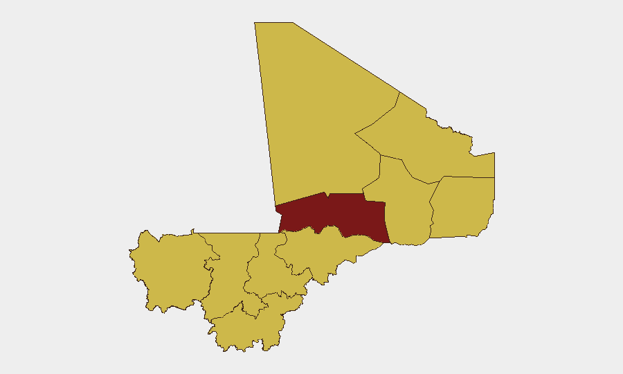
Timbuktu (risk 100) and Bamako (risk 88) dominate the sub-national landscape and reflect distinct threat vectors: Timbuktu faces armed-group proximity, supply-chain collapse, and humanitarian strain, while Bamako concentrates political instability, detention activity, and capital-city concentration of government/diplomatic targets. A secondary tier of seven regions—Ménaka, Kayes, Taoudénit, Kidal, Gao, Koulikoro, and Ségou—all score 70, indicating pervasive armed-group presence and banditry across the north-central corridor. Mopti and Sikasso (also risk 70) extend threat exposure into central and southwestern Mali, signaling that conflict and crime are not localized to the far north.
How GeoBit Would Assist
Corporate security and duty-of-care teams should deploy AOI Monitoring & Early Warning on Timbuktu, Bamako, and Ségou–Mopti to detect armed-group movement and checkpoint activity before tactical escalation. Intel Sweep (global event feeds, X/Telegram OSINT, multi-language search) combined with Network & Actor Analysis will corroborate or disambiguate unverified arrest and detention signals. Routing & Network Analysis supports real-time journey planning around fuel-shortage pinch points and known armed-group positions.
7-Day Outlook
No imminent tactical escalation is signaled; however, the tactical lull should not be misread as stability. Fuel shortages, water/power outages, and press restrictions are likely to persist and degrade institutional legitimacy and civil cohesion. Banditry and armed-group taxation of supply routes will remain the primary threat to movement and supply chains, particularly in the north and central regions.
Highest-Risk Areas — Ranked
| # | State / Region | Risk |
|---|---|---|
| 1 | Timbuktu | 100 |
| 2 | Bamako | 88 |
| 3 | Ménaka | 70 |
| 4 | Kayes | 70 |
| 5 | Taoudénit Region | 70 |
| 6 | Kidal | 70 |
| 7 | Gao | 70 |
| 8 | Koulikoro | 70 |
| 9 | Ségou Region | 70 |
| 10 | Sikasso Region | 70 |
| 11 | Mopti | 70 |
Sources
Previous Daily Briefs
A new Mali brief is written every day — each with its own risk map and downloadable CSV. Here's the last week; use the calendar to go further back.
📅 Browse every day by calendar →
Highlighted days have a brief. Tap a day for that day's map & analysis, or “csv” for that day's dataset ($5).