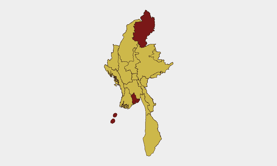
Situation Summary
Myanmar remains in a prolonged civil-war stalemate since the February 2021 coup, with no major escalation or de-escalation reported in the last 24–48 hours. Current open reporting confirms no verifiable, clearly dated major incidents (clashes, airstrikes, mass displacement) within the past two days; most available conflict feeds and media reference events from 23 June 2026 or earlier. The humanitarian and security situation remains fragile across non-state-controlled areas, particularly in the north and east, but the reporting lag and absence of 24–48-hour incident confirmation means the brief below reflects sustained threat posture rather than acute developments.
Key Developments
Open-source reporting does not currently support attribution of specific, verifiable incidents to the 26–27 June 2026 window. Available conflict datasets, UN humanitarian reports, and multi-sourced media explicitly note an absence of clearly dated major events in the last 24–48 hours. As of 28 June 2026, the most recent traceable incidents in public feeds are dated 23 June 2026 or earlier. Two flood events in Myanmar were flagged in the last reporting cycle (Event IDs 1103975, 1103937), but precise location, timing, and casualty data remain incomplete in open sources. Organisations with personnel or assets in Kachin, Yangon, or other high-risk states are advised to rely on real-time field channels and AOI monitoring rather than expect overnight incident confirmation from open media.
Highest-Risk Areas
Kachin State and Yangon dominate the sub-national ranking (risk scores 100 and 92.5 respectively), reflecting ongoing armed-group activity and civilian vulnerability in the north, combined with urban security, protest risk, and criminal activity in the commercial capital. Tanintharyi, Shan, Chin, Sagaing, Magway, and Rakhine all score 70—indicating sustained conflict-related or crime-driven risk across Myanmar's borderlands and ethnic-minority regions. The clustering of high scores in the north (Kachin, Sagaing, Magway, Chin, Shan) and south (Tanintharyi, Rakhine) reflects the geography of non-state armed-group presence and limited junta control; Yangon's elevated score reflects urban-security and economic-disruption risks rather than active combat.
How GeoBit Would Assist
Security and duty-of-care teams should employ AOI Monitoring & Early Warning on high-risk regions (Kachin, Sagaing, Yangon) to receive alerts when incident reporting becomes available, combined with OSINT Fusion & Corroboration (X/Twitter, Telegram, local-language sources) to catch undated social claims and validate them against multiple independent sources before operational decisions. GIS & Spatial Analysis and Routing & Network Analysis help map safe corridors and identify movement bottlenecks in contested zones. Conflict & Military force-structure tracking provides baseline understanding of armed-group disposition and junta posture in each region, enabling teams to distinguish normal activity from escalation signals.
7-Day Outlook
No major escalation or crisis-triggering event is forecast for the immediate 7-day window based on trend analysis through late June 2026. The civil-war stalemate is expected to persist, with routine low-level clashes and humanitarian pressures continuing in non-state zones. Personnel in Kachin, Sagaing, and Tanintharyi should maintain heightened situational awareness given the sustained-risk profile; urban staff in Yangon should monitor protest calendars and supply-chain disruption risk.
Highest-Risk Areas — Ranked
| # | State / Region | Risk |
|---|---|---|
| 1 | Kachin State | 100 |
| 2 | Yangon | 92.5 |
| 3 | Tanintharyi Region | 70 |
| 4 | Shan State | 70 |
| 5 | Chin | 70 |
| 6 | Sagaing Region | 70 |
| 7 | Wa State (Northern Region) | 70 |
| 8 | Magway | 70 |
| 9 | Mandalay | 70 |
| 10 | Rakhine | 70 |
| 11 | Ayeyarwady | 70 |
| 12 | Naypyitaw Union Territory | 70 |
Sources
Previous Daily Briefs
A new Myanmar brief is written every day — each with its own risk map and downloadable CSV. Here's the last week; use the calendar to go further back.
📅 Browse every day by calendar →
Highlighted days have a brief. Tap a day for that day's map & analysis, or “csv” for that day's dataset ($5).