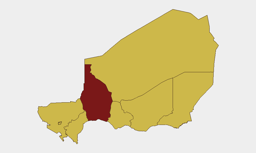
Situation Summary
Niger remains in the #24 global threat tier (composite score 91) with persistent instability concentrated in the Sahel and border regions. Open-source reporting for the last 24–48 hours shows no newly reported major security incidents, attacks, or civil unrest breaking into international news feeds; however, the absence of reporting does not indicate absence of threat. Chronic insurgency, banditry, and military operations continue across northern and eastern zones. Risk posture is stable but elevated, with Tahoua Region driving the highest sub-national threat profile.
Key Developments
- No major new incidents confirmed (last 24–48 hours): Open-source news aggregators, social media signals, and U.S. Embassy in Niamey feeds show no newly time-stamped security alerts, attacks, or infrastructure disruptions reported as of 3 July 2026. This represents a reporting lull rather than a security improvement.
- Tahoua Region remains highest-risk zone: Composite sub-national score of 93.6 reflects ongoing military and insurgent activity; no new tactical incidents reported in the last two days, but the region continues to drive national threat ranking.
- Potential signal noise from Nigeria reporting: Multiple event signals tagged "NIGERIA" vs. various actors (Scholar, Africa, Investor, Kenyan, etc.) in the event database may reflect Nigeria-centric reporting (e.g., Niger Delta oil operations, Lagos-area incidents) rather than Republic of Niger activity; requires manual corroboration to separate geographic signals.
- Arrest/Detain incident (1 July): One signal indicates an EMPLOYEE vs. NIGERIA arrest/detention event on 1 July; lacks geographic specificity and open-source confirmation—warrants internal follow-up with corporate HR and regional contacts.
- Military activity signals across multiple dates (30 June–2 July): Multiple "Conventional Military Force" and "Artillery/Tanks" signals are logged but lack confirmed location detail, casualty count, or confirmed combatant identity in available open-source feeds.
- U.S. Embassy maintains routine posture: No new travel advisory downgrades or curfew/closure announcements issued in the last 48 hours; advisory level remains consistent with prior guidance.
Highest-Risk Areas
Tahoua Region (93.6) is the primary driver of national risk and warrants the tightest operational security protocols for any personnel or assets in that zone; the gap between Tahoua and the next tier (Agadez, Zinder, Diffa, Tillabéri, and Niamey all at 63.6) suggests acute military or insurgent activity concentrated in the northwest. Five regions and the capital are ranked equally at 63.6, indicating widespread distribution of threat across northern, eastern, and central Niger; this suggests diffuse rather than localized risk, implying that inter-regional travel corridors and supply lines carry elevated exposure. Dosso and Maradi in the south-center also carry the mid-tier score, widening the geographic footprint of concern beyond traditional Sahel hotspots.
How GeoBit Would Assist
Corporate security teams should deploy Intel Sweep and multi-language OSINT fusion to monitor French-language local news, radio feeds, and Telegram/social channels for micro-incident reporting (road closures, checkpoint activity, banditry) not yet surfaced in English open-source feeds. Persistent AOI (Area-of-Interest) Monitoring & Early Warning on Tahoua and Agadez regions would provide automated alerting on new conflict or military signals, reducing reporting lag. Routing & Network Analysis capabilities enable identification of alternative supply and personnel transit routes that avoid Tahoua corridor pinch points.
7-Day Outlook
No major escalation is signaled in the available data for the next week; however, the sparseness of open-source reporting suggests intelligence gaps rather than stability. Risk posture in Tahoua and northern zones is expected to remain elevated and chronic, with routine banditry, military operations, and insurgent activity as baseline. Corporate security should maintain heightened duty-of-care protocols for anyone deployed north of Niamey and assume 48–72 hour reporting delays for incidents in remote regions.
Highest-Risk Areas — Ranked
| # | State / Region | Risk |
|---|---|---|
| 1 | Tahoua Region | 93.6 |
| 2 | Agadez Region | 63.6 |
| 3 | Zinder Region | 63.6 |
| 4 | Diffa Region | 63.6 |
| 5 | Tillabéri Region | 63.6 |
| 6 | Niamey | 63.6 |
| 7 | Dosso Region | 63.6 |
| 8 | Maradi Region | 63.6 |
Sources
Previous Daily Briefs
A new Niger brief is written every day — each with its own risk map and downloadable CSV. Here's the last week; use the calendar to go further back.
📅 Browse every day by calendar →
Highlighted days have a brief. Tap a day for that day's map & analysis, or “csv” for that day's dataset ($5).