Situation Summary
Nigeria maintains its position as the world's highest-threat environment (composite score 100/100), driven primarily by active insurgency across multiple regions and a sustained pattern of armed group activity. Over the past 48 hours, incident signals indicate heightened tension between state security forces, continued militant operations in the north and northeast, and emerging cyber targeting of financial infrastructure. The threat trajectory remains elevated with no indicators of de-escalation across key hotspots.
Key Developments
- Birnin Gwari, Kaduna State — 29–30 June 2026: Terrorist group abducted six school pupils in a rural corridor with established bandit activity, consistent with recurring pattern of child abductions in the northwest corridor.
- Makurdi, Benue State — 30 June 2026: Nigerian Army personnel allegedly opened fire on a police patrol, signaling serious armed friction between federal security force branches and requiring immediate investigation of command-and-control integrity.
- Kuru (Jos South LGA), Plateau State — 30 June 2026: Security operatives foiled an attempted intrusion into the National Institute for Policy and Strategic Studies (NIPSS) at approximately 1:30 a.m. local time; suspects fled and no casualties reported, but incident underscores vulnerability of critical national infrastructure to direct-action targeting.
- Katsina State — late June 2026: Security agencies arrested seven suspected Boko Haram/ISWAP commanders in a counter-terrorism operation, indicating continued operational presence of major militant franchises in the northwest.
- National banking and cyber infrastructure — late June 2026: Nigeria's Computer Emergency Response Team (ngCERT) issued warning to financial institutions regarding active phishing and lateral-movement campaigns targeting ATM and core banking systems, signaling shift toward financial-sector cyber operations.
Highest-Risk Areas
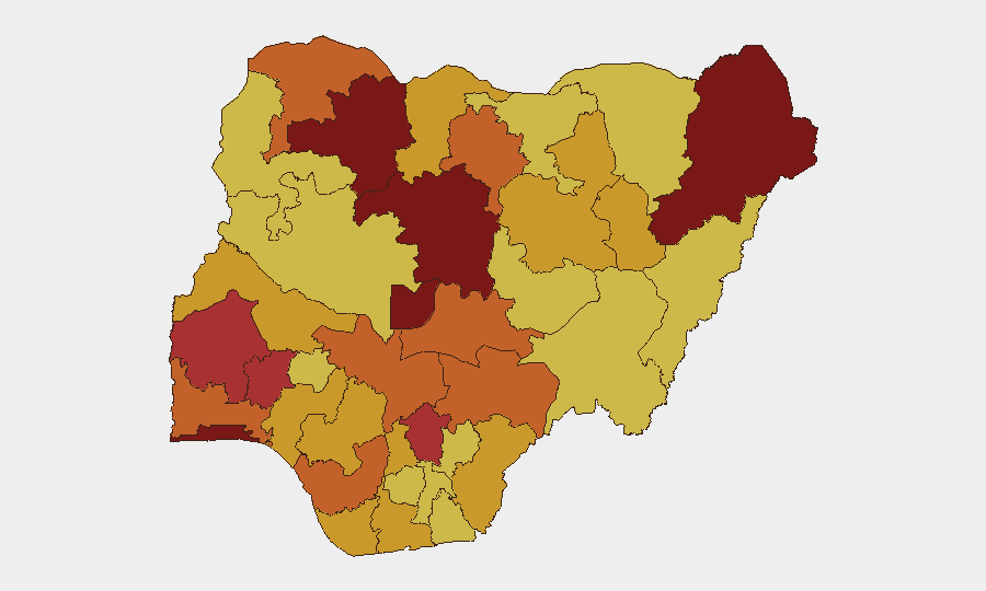
Kaduna State (risk 100) and Lagos State (96.3) anchor the threat landscape, with Borno State (96.2) and the Federal Capital Territory (93.3) close behind. Kaduna's ranking reflects sustained bandit and militant activity in rural corridors, recurring abductions, and the state's geographic position as a transit zone for armed groups moving between the northwest insurgency belt and central Nigeria. Lagos and Borno represent distinct but equally acute risks: Lagos combines criminal enterprise, organized labor tensions, and occasional militant probing, while Borno remains the epicenter of Boko Haram/ISWAP territorial and asymmetric operations. The Federal Capital Territory's elevated score reflects security-force fragmentation observed in recent incidents, critical infrastructure vulnerability, and the symbolic/operational value of targeting the seat of government.
How GeoBit Would Assist
Corporate security teams should prioritize AOI (Area-of-Interest) Monitoring & Early Warning on Kaduna, Lagos, Borno, and FCT to receive persistent alerting on incident clustering and emerging patterns. Intel Sweep, X/Twitter OSINT, and multi-language search capabilities enable real-time tracking of militant communications, government response signals, and cross-border actor movement. Routing & Network Analysis supports alternative journey planning and safe-corridor identification for personnel transit, while satellite and imagery analysis can support facility risk assessment and perimeter security baseline-setting in high-threat zones.
7-Day Outlook
Near-term trajectory points toward sustained militant activity in the northwest and northeast, with elevated risk of secondary abductions and rural-corridor attacks through early July. Inter-agency security-force tensions evident in recent incidents may complicate response coordination and increase civilian exposure during operations. Financial-sector cyber campaigns are likely to persist or escalate, warranting enhanced endpoint and network monitoring by corporate IT teams.
Highest-Risk Areas — Ranked
| # | State / Region | Risk |
|---|---|---|
| 1 | Kaduna State | 100 |
| 2 | Lagos State | 96.3 |
| 3 | Borno State | 96.2 |
| 4 | Federal Capital Territory | 93.3 |
| 5 | Zamfara State | 84.8 |
| 6 | Oyo State | 77.7 |
| 7 | Osun State | 77.4 |
| 8 | Enugu State | 76.4 |
| 9 | Delta State | 75.5 |
| 10 | Kano State | 75 |
| 11 | Ogun State | 74.9 |
| 12 | Nasarawa State | 74.1 |
Sources
Previous Daily Briefs
A new Nigeria brief is written every day — each with its own risk map and downloadable CSV. Here's the last week; use the calendar to go further back.
📅 Browse every day by calendar →
Highlighted days have a brief. Tap a day for that day's map & analysis, or “csv” for that day's dataset ($5).