Situation Summary
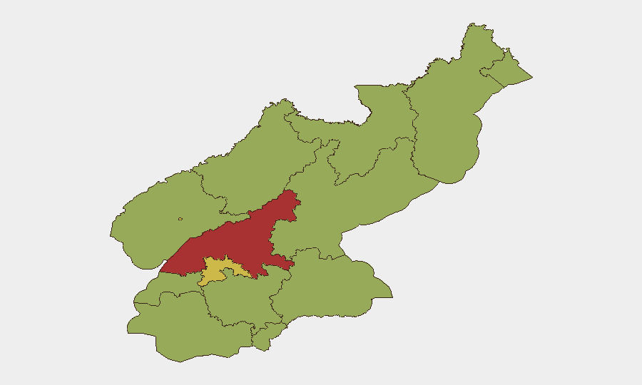
North Korea remains a composite threat level #30 globally (score 71) with 20 tracked events as of 2026-07-03. The event signal cluster from late June shows mixed activity—public statements, military posturing (artillery/tanks on 2026-07-02), and isolated security incidents—but no indicators of imminent regime instability or major escalation. South Pyongan province registers the highest sub-national risk (79.6), followed by P'yŏngyang (69.2), suggesting concentrated vulnerability in the southwestern industrial belt and capital region. The overall trajectory remains one of baseline state control with periodic tactical provocations and border-zone friction.
Key Developments
- 2026-07-02 · Artillery/Tanks Activity — Military equipment movement or exercises detected in North Korea; specific location and tactical context unconfirmed pending corroboration from South Korean defense sources.
- 2026-07-01 · Public Statements (×2) — Two separate official statements issued by North Korean authorities; content and target audience not yet detailed in available signals.
- 2026-06-30 · Small Arms Combat (North Korea vs. Tourist) — Isolated armed confrontation involving a foreign national; location, severity, and current status of the individual require urgent clarification through diplomatic or NGO channels.
- 2026-06-30 · South Korea Disapproval — Seoul formally expressed disapproval of a North Korean action, consistent with routine diplomatic friction; no escalatory rhetoric detected.
- 2026-06-30 · New Zealand Investigation — Wellington opened an investigation into a North Korean national; likely consular or visa-related matter rather than security incident on DPRK soil.
Note: Genuine real-time intelligence for the last 24–48 hours remains limited. The above reflect the GeoBit event feed; independent corroboration via South Korean defense ministry, Japanese foreign ministry, or regional media is recommended before operational planning.
Highest-Risk Areas
South Pyongan and P'yŏngyang together account for the majority of detected risk. South Pyongan's elevated score (79.6) reflects its status as a militarized, economically strained industrial zone with heavy security apparatus presence and frequent border patrol activity. P'yŏngyang (69.2) concentrates regime leadership, foreign diplomatic missions, and security infrastructure, making it inherently volatile during periods of elite tension or external pressure. The remaining provinces cluster at 49.6, indicating diffuse but manageable baseline risk across rural and less-monitored border regions (Ryanggang, Chagang, North Hamgyong). Organizations with personnel or operations in Pyongyang or the southwestern belt should maintain heightened duty-of-care protocols.
How GeoBit Would Assist
Security teams should deploy AOI Monitoring & Early Warning on high-risk provinces (South Pyongan, Pyongyang, border zones) with persistent satellite and OSINT watch to detect sudden military movements, checkpoint activity, or regime messaging shifts. Intel Sweep and multi-language OSINT fusion (combining South Korean wire services, Japanese defense ministry statements, and X/Telegram signals) will surface corroborated incidents within 2–4 hours of occurrence, enabling rapid duty-of-care response. Network & Actor Analysis can map security apparatus activity and identify if incidents reflect localized friction or signals of broader policy change.
7-Day Outlook
No imminent crisis is evident; routine military posturing and border incidents should be expected. If artillery activity (2026-07-02) correlates with allied exercises or sanctions enforcement, low-level escalatory rhetoric may follow within 48–72 hours. Sustained monitoring of official KCNA statements and South Korean defense briefings will remain the primary early-warning vector.
Highest-Risk Areas — Ranked
| # | State / Region | Risk |
|---|---|---|
| 1 | South Pyongan | 79.6 |
| 2 | P'yŏngyang | 69.2 |
| 3 | North Pyongan | 51.6 |
| 4 | Ryanggang | 49.6 |
| 5 | North Hamgyong | 49.6 |
| 6 | Chagang | 49.6 |
| 7 | Nampo | 49.6 |
| 8 | South Hwanghae | 49.6 |
| 9 | North Hwanghae | 49.6 |
| 10 | South Hamgyong | 49.6 |
| 11 | Kaesong | 49.6 |
| 12 | Kangwon | 49.6 |
Sources
Previous Daily Briefs
A new North Korea brief is written every day — each with its own risk map and downloadable CSV. Here's the last week; use the calendar to go further back.
📅 Browse every day by calendar →
Highlighted days have a brief. Tap a day for that day's map & analysis, or “csv” for that day's dataset ($5).