Situation Summary
Panama remains at composite threat rank #52 globally, with crime and gang violence as the primary driver (35/100 composite score). Recent violent incidents in the capital region and surrounding metropolitan areas—including execution-style killings of civilians in vehicles—signal sustained operational tempo by criminal actors. A severe-weather advisory (valid 28–31 August) compounds infrastructure and travel risk. The security trajectory is one of persistent, localized criminal violence rather than systemic unrest or state collapse, but with no clear de-escalation signals in the near term.
Key Developments
- Cocaine seizure at Bayano checkpoint, Chepo (28 Aug, Panama Province). Senafront anti-narcotics units intercepted ~300 packages of suspected cocaine at a key road checkpoint east of Panama City, confirming active drug-trafficking networks on major transit corridors.
- Armed robbery arrest in Río Hato (28 Aug, Coclé). National Police arrested a minor for armed robbery committed on horseback, reflecting youth involvement in organized crime in a tourist-accessible region and suggesting resource constraints in law enforcement.
- Severe-weather advisory issued nationwide (28–31 Aug). Panama's Civil Protection agency (Sinaproc) issued an alert for significant rains, thunderstorms, potential flooding, and landslides through 31 August, elevating infrastructure and travel disruption risk during the window.
- Curfews maintained in San Miguelito, Antón, and Río Hato (status as of 28 Aug). Nighttime curfews remain in force in parts of San Miguelito (Panama Province) and towns in Coclé province in response to homicide surge (300 recorded in first half of 2026), indicating continued heightened crime suppression operations.
- Execution-style killings in capital region (reported 26 Aug, incidents ~24–26 Aug). Two armed attacks on couples in vehicles within 48 hours in Panama Norte and San Miguelito left four dead, described as targeted killings and reflecting escalated violence in high-density urban zones.
Highest-Risk Areas
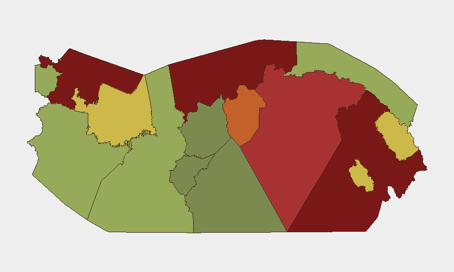
Darién (95) and Colón (88) remain the highest-risk provinces, driven by trafficking networks, gang presence, and limited state authority in border zones and maritime gateways. Bocas del Toro (82) and Panamá Province (78) follow, with Panamá Oeste (75) and Ngäbe-Buglé (68) also elevated. The capital region (Panama City and San Miguelito) is not separately ranked but shows acute localized violence. Risk is concentrated in areas with weak institutional presence, high drug-trafficking throughput, or dense informal urban settlements where gang competition for territory and control generates sustained homicide rates.
How GeoBit Would Assist
Intel Sweep and Event Feed Monitoring would provide real-time correlation of gang activity, trafficking movements, and violent incidents across tracked zones, enabling duty-of-care teams to update travel risk and asset-protection posture. AOI Monitoring & Early Warning on Darién, Colón, and San Miguelito would alert teams to emerging incidents (roadblocks, cartel activity, curfew enforcement) before they affect personnel. Network & Actor Analysis would map gang structures and territorial disputes to anticipate violence concentration and predict safe passage windows and routes.
7-Day Outlook
Violent crime is expected to remain at current operational tempo through early September, with no indicators of truce, ceasefire, or major law-enforcement disruption of gang networks. Weather risk (flooding, landslides) will compound travel delays and may temporarily disrupt supply chains and access to remote areas. Curfews and checkpoint activity will likely persist in San Miguelito and Coclé as authorities attempt to suppress homicides.
Highest-Risk Areas — Ranked
| # | State / Region | Risk |
|---|---|---|
| 1 | Darién | 95 |
| 2 | Colón | 88 |
| 3 | Bocas del Toro | 82 |
| 4 | Panamá Province | 78 |
| 5 | Panamá Oeste | 75 |
| 6 | Ngäbe-Buglé | 68 |
| 7 | Emberá-Wounaan | 62 |
| 8 | Veraguas | 58 |
| 9 | Chiriquí | 48 |
| 10 | Naso Tjër Di | 45 |
| 11 | Guna Yala | 42 |
| 12 | Coclé | 35 |
Sources
Previous Daily Briefs
A new Panama brief is written every day — each with its own risk map and downloadable CSV. Here's the last week; use the calendar to go further back.
- August 28, 2026
- August 26, 2026
- August 25, 2026
- August 24, 2026
- August 23, 2026
- August 22, 2026
- August 21, 2026
📅 Browse every day by calendar →
Highlighted days have a brief. Tap a day for that day's map & analysis, or “csv” for that day's dataset ($5).
Atlas — our AI intelligence desk — emails them this snapshot personally. Nothing else, no list.