Situation Summary
Sudan remains the fourth-highest-threat country globally, driven by active civil conflict and a composite threat score of 100. Signals from the past 48 hours indicate ongoing institutional strain, including disapproval actions against military and security forces, territorial occupation by armed groups in Darfur, arrests of police officers, and public statements from students and civilians critical of the government. The conflict trajectory remains volatile with no indication of de-escalation.
Key Developments
- 2026-07-07 · North Kordofan State / Central Darfur – Armed fighters reported occupying territory in Darfur; concurrent arrest/detention activity by Sudanese authorities suggests operational instability across security and militant sectors.
- 2026-07-07 · National-level – Sudan government faces disapproval action; concurrent threats issued by rights groups and UN entities indicate mounting international pressure and domestic accountability scrutiny.
- 2026-07-06 · Countrywide – Police officer arrests and detentions by Sudanese authorities suggest internal security-force fracturing or disciplinary action; pattern indicates institutional control challenges.
- 2026-07-07 · Al Khartum (implied) – Student and civilian public statements critical of Sudan government recorded; signals underlying civil discontent and risk of protest activity.
- 2026-07-04 · Diplomatic – Sudan disapproved actions against United Arab Emirates; reflects regional diplomatic deterioration and potential sanctions/resource-access implications for operations.
- 2026-07-06 · International custody – French nationals or French-related arrest/detention incident recorded; suggests foreign-national risk and potential consular/evacuation complications.
Highest-Risk Areas
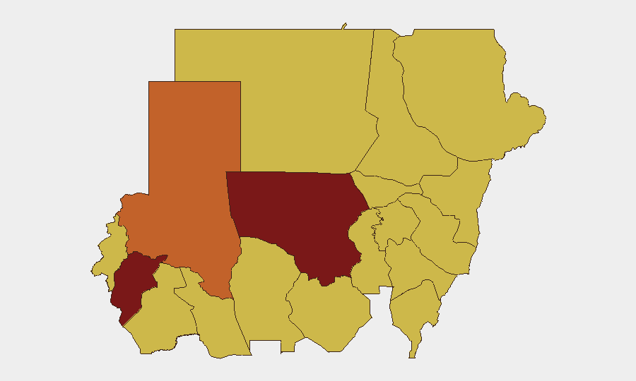
North Kordofan State (risk 100) and Central Darfur State (risk 91) are the primary drivers of national risk, both experiencing active armed conflict, territorial occupation, and resource-competition violence. The remaining high-risk tier—North Darfur, Blue Nile, and River Nile—maintains scores of 70–73 due to sustained militia activity and weak state control. Al Khartum, the capital, ranks at risk level 70, indicating that political instability and civil unrest extend to the seat of government; this elevation reflects the national-scale nature of the conflict and the erosion of institutional authority evident in the arrest patterns and disapproval actions recorded in the past 48 hours.
How GeoBit Would Assist
Security teams with personnel or assets in Sudan should employ Intel Sweep and multi-language OSINT fusion to monitor real-time event signals across Darfur and Kordofan states, cross-referenced with entity and sentiment analysis to detect shifts in military/militia capability or intent. Persistent Area-of-Interest (AOI) monitoring and early-warning alerting for high-risk states would enable duty-of-care teams to trigger evacuation, shelter-in-place, or route-change decisions before tactical deterioration. Alternative routing and network analysis can identify safer travel corridors and safe-house logistics in lower-risk states (e.g., Red Sea, Kassala) if operations require continued activity or personnel movement.
7-Day Outlook
The next seven days are likely to see continued territorial contestation in Darfur and Kordofan, with police and military authority actions indicating internal instability. International pressure (UN, rights groups, UAE tensions) will persist, creating diplomatic risk for foreign nationals and potentially complicating consular access. No significant de-escalation is forecast; risk remains elevated across all high-tier states.
Highest-Risk Areas — Ranked
| # | State / Region | Risk |
|---|---|---|
| 1 | North Kordofan State | 100 |
| 2 | Central Darfur State | 91 |
| 3 | North Darfur State | 73 |
| 4 | Blue Nile | 70 |
| 5 | River Nile State | 70 |
| 6 | Al Khartum | 70 |
| 7 | Aj Jazira | 70 |
| 8 | Red Sea State | 70 |
| 9 | Al Qadarif State | 70 |
| 10 | Kassala State | 70 |
| 11 | Sennar State | 70 |
| 12 | South Darfur State | 70 |
Previous Daily Briefs
A new Sudan brief is written every day — each with its own risk map and downloadable CSV. Here's the last week; use the calendar to go further back.
📅 Browse every day by calendar →
Highlighted days have a brief. Tap a day for that day's map & analysis, or “csv” for that day's dataset ($5).
Atlas — our AI intelligence desk — emails them this snapshot personally. Nothing else, no list.