Situation Summary
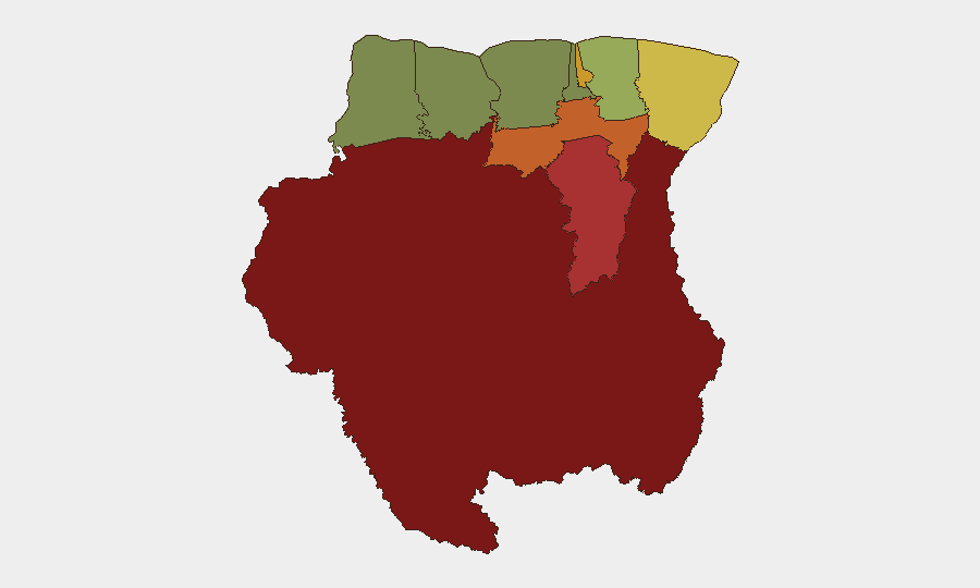
Suriname remains a low-threat environment by global standards (composite threat score 4; #167 globally), with no credibly documented security incidents, civil unrest, or infrastructure disruptions confirmed in the last 24–48 hours as of 8 August 2026. Risk concentration is markedly geographic rather than nationwide: interior and southeastern districts face elevated exposure to criminal activity, trafficking, and illegal resource extraction, while coastal and western regions remain substantially lower-risk. The current trajectory suggests stable baseline conditions with persistent localized vulnerabilities in remote areas.
Key Developments
No discrete security incidents were independently verified in Suriname during the 24–48 hour window preceding this brief (6–8 August 2026). The most recent credibly dated incident—a suspected boat capsize in the Matawai area on 30 July with one fatality and one person missing—falls outside the current reporting window. A police and military "Clean Sweep Operatie" in Sipaliwini was noted as of 4 August, but available reporting does not characterize it as a response to a new incident or as having triggered immediate operational impact. Single-source reporting of an illegal firearm intercept in Kalebaskreek on 8 August exists but lacks cross-verification. No routine criminal or civil-unrest reports meet the dual criteria of recency and independent confirmation.
Highest-Risk Areas
Sipaliwini (risk score 92) and Brokopondo (78) dominate Suriname's threat profile and reflect the interior mining, logging, and trafficking-corridor exposure endemic to the forested south and east. Para (74) and Paramaribo (71) register elevated scores reflecting urban crime and port-related criminal activity in the capital. Marowijne (68), the eastern border region with French Guiana, experiences cross-border trafficking and smuggling pressures. Collectively, these five districts account for the vast majority of Suriname's tracked risk; Coronie and Nickerie in the west remain minimal-threat zones (scores 12 and 8). Risk drivers include artisanal and illegal mining, narcotics transshipment, and limited state authority in remote zones rather than organized insurgency or political instability.
How GeoBit Would Assist
Security teams with personnel or assets in Suriname should employ AOI Monitoring & Early Warning on high-risk districts (particularly Sipaliwini, Brokopondo, and Paramaribo) to detect emerging criminal activity, trafficking patterns, or enforcement operations before they escalate. OSINT fusion & corroboration across local news, social media (X/Telegram), and open-source databases would provide early detection of localized incidents and distinguish credible threats from noise—critical in a low-event environment where false alarms carry operational cost. Routing & Network Analysis capabilities enable pre-planned alternative movement corridors and risk-aware journey planning for staff transiting interior or eastern districts.
7-Day Outlook
No significant change in the current low-threat baseline is anticipated over the next seven days. Seasonal factors (August is the dry season) may support increased activity in mining and logging zones, potentially raising localized criminal opportunity in Sipaliwini and Brokopondo. Routine enforcement operations are likely to continue; any marked uptick in police or military activity should trigger heightened monitoring of nearby personnel and supply chains.
Highest-Risk Areas — Ranked
| # | State / Region | Risk |
|---|---|---|
| 1 | Sipaliwini | 92 |
| 2 | Brokopondo | 78 |
| 3 | Para | 74 |
| 4 | Paramaribo | 71 |
| 5 | Marowijne | 68 |
| 6 | Commewijne | 42 |
| 7 | Wanica | 38 |
| 8 | Saramacca | 29 |
| 9 | Coronie | 12 |
| 10 | Nickerie | 8 |
Sources
Previous Daily Briefs
A new Suriname brief is written every day — each with its own risk map and downloadable CSV. Here's the last week; use the calendar to go further back.
📅 Browse every day by calendar →
Highlighted days have a brief. Tap a day for that day's map & analysis, or “csv” for that day's dataset ($5).
Atlas — our AI intelligence desk — emails them this snapshot personally. Nothing else, no list.