Situation Summary
Syria remains in a critical escalation phase driven by intensified Israeli military operations across southern and central territories, concurrent with broader Iran–US regional hostilities and elevated US ground operations in the east. The past 48 hours have seen a marked spike in air strikes (reported at 480+ attacks), cross-border incursions near the Golan, and documented attacks on US personnel, compounded by Syrian government security tightening and high-level diplomatic coordination with Türkiye. The combination of external military pressure, internal institutional activation, and fragmented but corroborated incident reporting suggests elevated risk of collateral civilian impact, infrastructure disruption, and sudden movement restrictions, particularly in the south and around military/logistical nodes.
Key Developments
- Israeli air and ground offensive, southern Syria (Quneitra, Daraa, Sweida), June 30–July 1: Multiple credible reports of hundreds of Israeli strikes and claimed ground incursion into southern Syrian territory near the Golan line in the past 48 hours; Syrian state media condemned attacks as sovereignty violations and called for UN intervention.
- Israeli strikes on Iran-linked targets, nationwide (June 30–early July 1): As part of broader Iran war escalation, Israeli warplanes intensified strikes on sites assessed as linked to Iranian-aligned groups across Syrian territory; one report cites ~480 attacks in 48 hours; Syrian Foreign Ministry labeled attacks "flagrant violation" of territorial integrity.
- Ankara–Damascus security talks, Damascus (June 30): Turkish Interior Minister met Syrian Interior Minister and President al-Sharaa at Tishreen and People's Palaces to discuss border security, law enforcement, counter-narcotics, and refugee repatriation—indicating active high-level institutional coordination affecting cross-border movements and domestic security posture.
- US-responding attacks on US personnel, eastern Syria (late June 30–July 1): US forces conducted strikes in response to multiple attacks on American personnel in Syria in the past 24 hours; Arab media reports US and Syrian forces wounded during joint patrol, confirming active ground operations and IED/drone attack exposure in the east.
- Syrian airspace and navigational restrictions (June 30–July 1): Syrian officials cited security incidents in the past 48 hours and criticized restrictions on navigational freedoms, signaling possible short-notice changes to aviation routing and maritime movements.
- Enhanced security posture in Damascus (June 30–July 1): Authorities emphasized strengthened law enforcement and border control; concurrent with Israeli strikes and Turkish meetings, visible uptick in checkpoints, security force presence, and scrutiny of movement near government and diplomatic sites expected.
Highest-Risk Areas
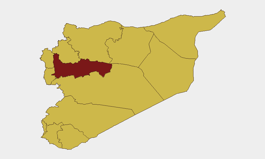
Hama Governorate stands significantly above all other regions (risk score 96.1), likely reflecting its role as a military coordination hub and proximity to Israeli-strike zones. Southern governorates (Quneitra, Daraa, Dar'a) all rank at 66.1 and face direct Israeli air and ground activity, making them the immediate flashpoint for collateral risk and infrastructure disruption. Damascus (66.6) and Lattakia/Tartus coastal zones (66.1 each) present elevated risk from air strikes on suspected military/logistics targets and heightened internal security controls. Eastern zones (Ar-Raqqa, Homs) remain elevated due to ongoing US–SDF operations and exposure to indirect fire from attacks on US personnel.
How GeoBit Would Assist
Security teams should deploy AOI Monitoring & Early Warning on Hama, southern governorates, and US/SDF positions to detect sudden escalation and movement closures. Conflict & Military (battle mapping, force structure) and Satellite & Imagery analysis enable real-time tracking of Israeli strike patterns and infrastructure damage. Routing & Network Analysis provides alternative journey planning around active strike zones and checkpoint concentrations, while multi-language OSINT and event-feed fusion rapidly corroborate fragmentary incident reports and identify second-order effects on civilians and supply chains.
7-Day Outlook
Israeli operations are likely to sustain elevated tempo against southern and central targets through early July, with Syria maintaining diplomatic engagement with Türkiye and public calls for international intervention. Security controls in Damascus and major cities will remain tightened; organizations should expect checkpoint delays, airspace routing changes, and short-notice movement advisories. Risk of collateral civilian impact, particularly in Hama and the south, remains acute; contingency planning for rapid evacuation or in-place shelter is warranted for non-essential personnel.
Highest-Risk Areas — Ranked
| # | State / Region | Risk |
|---|---|---|
| 1 | Hama Governorate | 96.1 |
| 2 | Damascus Governorate | 66.6 |
| 3 | Lattakia Governorate | 66.1 |
| 4 | Tartus Governorate | 66.1 |
| 5 | UNDOF | 66.1 |
| 6 | Al-Quneitra Governorate | 66.1 |
| 7 | Dar'a Governorate | 66.1 |
| 8 | Idleb Governorate | 66.1 |
| 9 | Aleppo Governorate | 66.1 |
| 10 | Ar-Raqqa Governorate | 66.1 |
| 11 | Homs Governorate | 66.1 |
| 12 | Rif Dimashq Governorate | 66.1 |
Sources
Previous Daily Briefs
A new Syria brief is written every day — each with its own risk map and downloadable CSV. Here's the last week; use the calendar to go further back.
📅 Browse every day by calendar →
Highlighted days have a brief. Tap a day for that day's map & analysis, or “csv” for that day's dataset ($5).