Situation Summary
Ukraine remains at elevated military and civilian risk as of 20 July 2026, ranked #7 globally with 1,378 tracked threat events. Sustained Russian air and artillery operations against major urban centres and port infrastructure continue, with concurrent reports of Ukrainian conventional military engagement. Political friction—including recent ministerial dismissals—adds institutional strain alongside active kinetic conflict across multiple oblasts.
Key Developments
- Kyiv (19 July) — Russian missile/drone strike reported overnight, resulting in at least one confirmed death and multiple injuries across the capital.
- Odesa Oblast (18 July) — Russian artillery and/or air strikes targeted port and energy infrastructure; sustained campaign against maritime and civilian assets ongoing.
- Kyiv (19 July) — Ukrainian conventional military force engaged in reported incident affecting civilian areas; exact scope and casualties require further verification.
- Kharkiv Oblast (19 July) — Artillery/tank activity reported; ongoing conventional operations in northeastern sector.
- Russia–Ukrainian forces (19 July) — Rejection statement issued by Russian spokesperson regarding Ukrainian positions or proposals; escalatory rhetoric continuing.
- Cargo/maritime (19 July) — Russian forces engaged with cargo vessel; suggests continued targeting of maritime transport in Black Sea or Azov region.
- Military mobilization (18 July) — Russian military mobilization activity detected, indicating potential force concentration or repositioning.
- Government/political (17–19 July) — Ministerial disapproval and public statements by mayors and officials; Defence Minister Mykhailo Fedorov dismissal preceded reported public discontent (background: ongoing since mid-July).
Highest-Risk Areas
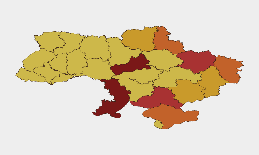
Kyiv (risk 100) dominates the risk landscape, reflecting sustained Russian air operations and the concentration of political/military decision-making. Cherkasy Oblast (92.9) and Odesa Oblast (85.4) follow, with Odesa's maritime vulnerability and port targeting particularly acute for corporate supply chains and energy exports. Kharkiv (79.5) and Kherson (77.7) oblasts remain contested or proximity-threatened zones. Luhansk, Sumy, and Donetsk remain elevated due to ongoing military operations and proximity to Russian-controlled or contested territory.
How GeoBit Would Assist
Security and duty-of-care teams should deploy Area-of-Interest (AOI) Monitoring & Early Warning on key facilities and travel corridors in Kyiv, Odesa, and Kharkiv to trigger alerts on imminent strikes or military movement. Conflict mapping and force-structure tracking enable real-time situational awareness of Ukrainian and Russian unit dispositions, informing evacuation or shelter decisions. Multi-language OSINT and X/Telegram feeds combined with sentiment & temporal analysis provide early signal of political instability or escalation rhetoric before formal announcements. For maritime and logistics teams, maritime tracking and alternative route/network analysis mitigate port closures and transport disruption.
7-Day Outlook
Russian air operations are expected to persist in major urban centres and energy infrastructure through late July. Political instability may create command-and-control friction, increasing civilian risk from erratic military action or inadequate early warning. De-escalation signals remain absent; sustained high threat posture across Kyiv, Odesa, and eastern oblasts should be assumed through at least 27 July.
Highest-Risk Areas — Ranked
| # | State / Region | Risk |
|---|---|---|
| 1 | Kyiv | 100 |
| 2 | Cherkasy Oblast | 92.9 |
| 3 | Odesa Oblast | 85.4 |
| 4 | Kharkiv Oblast | 79.5 |
| 5 | Kherson Oblast | 77.7 |
| 6 | Luhansk Oblast | 74.9 |
| 7 | Sumy Oblast | 73.2 |
| 8 | Autonomous Republic of Crimea | 73.2 |
| 9 | Chernihiv Oblast | 71.5 |
| 10 | Donetsk Oblast | 71.2 |
| 11 | Zaporizhia Oblast | 71 |
| 12 | Dnipropetrovsk Oblast | 70.7 |
Sources
Previous Daily Briefs
A new Ukraine brief is written every day — each with its own risk map and downloadable CSV. Here's the last week; use the calendar to go further back.
📅 Browse every day by calendar →
Highlighted days have a brief. Tap a day for that day's map & analysis, or “csv” for that day's dataset ($5).
Atlas — our AI intelligence desk — emails them this snapshot personally. Nothing else, no list.