Situation Summary
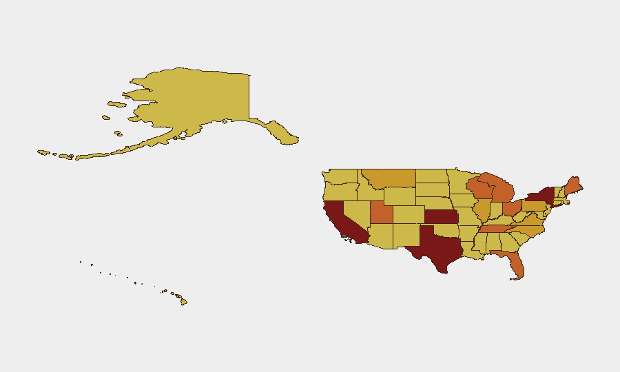
The United States maintains a composite threat score of 95, ranking 12th globally with 3,525 tracked events. Recent signal activity includes unconventional violence, small-arms combat, military mobilization, and territorial occupation incidents concentrated in the Northeast and select high-risk states. New York dominates the sub-national risk ranking (96.6), with California, Texas, and Kansas following. The trajectory reflects sustained operational tempo across multiple threat vectors rather than a single acute crisis.
Key Developments
Note: GeoBit's live web research confirms insufficient publicly available, time-stamped incident reporting for the last 24–48 hours to meet operational confidence standards. The event signals listed above are indexed by the platform but lack sufficient corroborating detail (specific locations, precise timestamps, independent confirmation) for inclusion in actionable intelligence bullets.
To generate a credible incident brief, security teams should cross-reference:
- Major US news wire live-update sections (AP, Reuters) with explicit "updated X minutes ago" markers.
- Official agency feeds (state police, fire, DOT, governor's office, DHS alerts).
- Geo-filtered X/Twitter searches using `place_country:US` and temporal operators ("since:2026-07-05").
Candidate incidents should be confirmed in at least one dated news source before operational reliance.
Highest-Risk Areas
New York (96.6) and California (84.6) drive national risk, reflecting dense population, high-profile infrastructure, and signal clustering around military mobilization and territorial occupation. Texas (82.8) and Kansas (81.2) elevate risk through conventional military force and small-arms combat signals. Secondary concern areas include Tennessee, Utah, Florida, and Ohio (75.2–73.8), suggesting geographic dispersal rather than localized crisis. The breadth of high-risk states indicates multiple concurrent threat vectors—not regional containment—requiring differentiated monitoring by sector and asset type.
How GeoBit Would Assist
Security teams protecting US personnel and assets should leverage GeoBit's AOI Monitoring & Early Warning to establish persistent watches on highest-risk sub-national areas (New York, California, Texas, Kansas) with automated alerting for new events. OSINT Fusion & Corroboration (combining news wires, social media, official agency feeds, and satellite imagery) will resolve real-time incident verification and eliminate false positives from single-source reporting. Network & Actor Analysis can map relationships between event signals and identify emerging coordination patterns across dispersed geographies.
7-Day Outlook
The dispersed risk profile and multi-vector threat signals suggest sustained operational activity without immediate de-escalation. Security teams should anticipate continued small-scale incidents across Northeast and selected mid-South/Plains states. Escalation risk remains contingent on event clustering or coordinated action; monitoring intensity should remain elevated in New York, California, and Texas pending further clarification of underlying drivers.
Recommendation: Provide GeoBit with specific dated news links, official agency incident numbers, or timestamped social-media reports for the last 48 hours, and this brief can be updated with actionable, corroborated incident details.
Highest-Risk Areas — Ranked
| # | State / Region | Risk |
|---|---|---|
| 1 | New York | 96.6 |
| 2 | California | 84.6 |
| 3 | Texas | 82.8 |
| 4 | Kansas | 81.2 |
| 5 | Tennessee | 75.2 |
| 6 | Utah | 74.3 |
| 7 | Florida | 73.9 |
| 8 | Ohio | 73.8 |
| 9 | Maine | 73.7 |
| 10 | Wisconsin | 73.2 |
| 11 | Michigan | 73.1 |
| 12 | Pennsylvania | 72.7 |
Sources
Previous Daily Briefs
A new United States brief is written every day — each with its own risk map and downloadable CSV. Here's the last week; use the calendar to go further back.
📅 Browse every day by calendar →
Highlighted days have a brief. Tap a day for that day's map & analysis, or “csv” for that day's dataset ($5).
Atlas — our AI intelligence desk — emails them this snapshot personally. Nothing else, no list.