Situation Summary
Venezuela remains a complex operating environment dominated by pre-existing violent crime, political instability, and arbitrary detention risk, compounded since 24 June by severe infrastructure damage from a double earthquake that has killed over 4,300 people and displaced approximately 18,000. The earthquake impact continues to strain law enforcement, emergency services, and basic utilities across a multi-state corridor, creating secondary security risks including looting, service disruption, and constrained mobility. No major new political violence, protests, or criminal incidents have been independently corroborated in the last 24–48 hours beyond ongoing earthquake recovery operations. The threat environment remains elevated but not sharply escalating as of 14 July.
Key Developments
- La Guaira state (coastal epicentral zone) – ongoing as of 13 July
Large-scale housing and road damage reported by UN OCHA and media; thousands remain displaced; emergency logistics and travel access remain severely constrained.
- Yaracuy state (epicentral region) – ongoing as of 13 July
Widespread building destruction including health facilities; ongoing rescue and shelter operations; road infrastructure damage limits access and movement.
- Caracas and Federal District – ongoing as of 13 July
Structural damage and intermittent electricity, communications, and healthcare services reported; operational security implications from unsafe structures and pressure on emergency services.
- Multi-state transport corridor (La Guaira–Caracas–Miranda–Aragua–Carabobo–Falcón) – ongoing as of 13 July
Over 1,000 buildings confirmed damaged; significant constraints on movement and logistics affecting travel safety and supply chains.
- National casualty figures – updated 12–13 July
Death toll now confirmed above 4,300–4,500; over 16,700 injured; approximately 18,000 homeless; scale of humanitarian stress creating indirect security and crime risk through service collapse.
- Foreign travel advisories – reviewed July 2026
Multiple governments (US, EU, others) maintain "do not travel" advisories citing persistent violent crime, political instability, arbitrary detention risk, and now earthquake-driven infrastructure failure.
Highest-Risk Areas
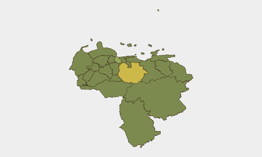
Guarico State leads the sub-national ranking (61.1), followed by Federal District (44.6) and Carabobo (42), reflecting concentrations of organized crime, gang activity, and state capacity stress. The Federal District and coastal/northern states (La Guaira, Vargas) now carry acute secondary risk from earthquake damage, service disruption, and humanitarian pressure. Guarico and border-adjacent states (Apure, Táchira) remain elevated due to transnational criminal networks and smuggling. The ranking underscores that highest absolute risk is in the capital region and core northern corridor, while organized-crime and trafficking pressure persists in peripheral and border zones.
How GeoBit Would Assist
Security teams with personnel or assets in Venezuela should employ AOI (Area-of-Interest) Monitoring & Early Warning on high-risk states (Guarico, Federal District, Carabobo) to detect emerging protests, criminal incidents, or civil unrest in near real-time. Intel Sweep and multi-language OSINT fusion (X, Telegram, local media, radio SIGINT) provide early signals of political instability or cartel activity shifts. Routing & Network Analysis helps identify alternative travel corridors and safe passage planning around earthquake-damaged infrastructure and active crime zones.
7-Day Outlook
Earthquake recovery operations will remain the dominant driver of infrastructure risk and service disruption through mid-to-late July, with no immediate signs of major new political or criminal escalation. Organized crime activity may increase opportunistically in damaged zones due to reduced law enforcement presence. Risk trajectory is stable but elevated; no sharp escalation anticipated in the next week absent new political trigger or natural disaster.
Highest-Risk Areas — Ranked
| # | State / Region | Risk |
|---|---|---|
| 1 | Guarico State | 61.1 |
| 2 | Federal District | 44.6 |
| 3 | Carabobo State | 42 |
| 4 | Vargas State | 34.7 |
| 5 | Lara State | 33.7 |
| 6 | Apure State | 32.1 |
| 7 | Anzoategui State | 31.8 |
| 8 | Monagas State | 31.8 |
| 9 | Zulia State | 31.5 |
| 10 | Barinas State | 31.5 |
| 11 | Tachira State | 31.5 |
| 12 | Falcon State | 31.1 |
Sources
Previous Daily Briefs
A new Venezuela brief is written every day — each with its own risk map and downloadable CSV. Here's the last week; use the calendar to go further back.
📅 Browse every day by calendar →
Highlighted days have a brief. Tap a day for that day's map & analysis, or “csv” for that day's dataset ($5).
Atlas — our AI intelligence desk — emails them this snapshot personally. Nothing else, no list.