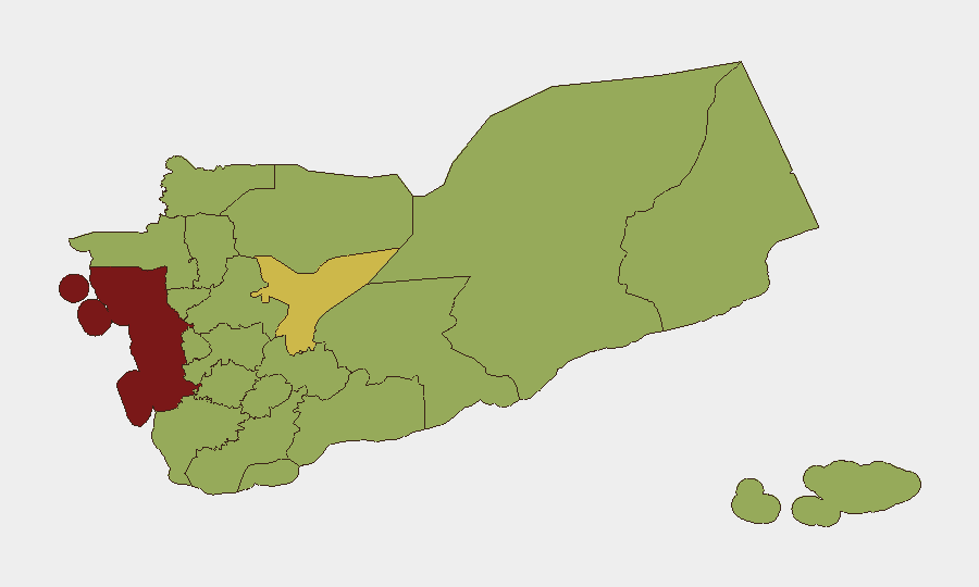
Situation Summary
Yemen remains in active civil conflict with escalating military operations across multiple fronts as of 27 July 2026. Over the last 48 hours, Saudi-led coalition and Yemeni government forces have intensified airstrikes against Houthi positions in Marib, Al-Jawf, and Hodeidah, while Houthi naval and missile units have simultaneously targeted Saudi shipping in the Red Sea and claimed strikes against Saudi energy infrastructure. The convergence of renewed ground offensives, maritime attacks, and cross-border strikes signals a tactical escalation that directly threatens commercial transit, energy assets, and personnel in high-risk zones.
Key Developments
- Hodeidah city & Kamaran Island (Al Hudaydah Governorate), 24 July 2026 — Saudi coalition airstrikes struck Houthi military and telecommunications facilities near Hodeidah port and on Kamaran Island, targeting command infrastructure and communications networks.
- Marib & Al-Jawf governorates, 25 July 2026 — Yemeni government and coalition aircraft conducted coordinated airstrikes on Houthi missile/drone launch sites, arms depots, and reinforcement columns across Majzar, Al-Safra, Al-Jubah, and Mahliyah districts, resulting in reported Houthi casualties.
- Bab al-Mandab Strait & Red Sea, 25–27 July 2026 — Houthi forces attacked three Saudi oil tankers and forced Saudi-linked vessels to divert; a commercial tanker reported an unidentified projectile splash with no damage confirmed. Maritime reporting indicates sustained blockade posture and elevated risk to shipping.
- Jizan & Yanbu (Saudi Arabia, attacks launched from Yemen), 25 July 2026 — Houthi-aligned units announced ballistic and cruise-missile strikes on Aramco facilities; Saudi sources report interception of two ballistic missiles targeting Yanbu refineries with no confirmed damage.
- Al-Jawf airspace, 26–27 July 2026 — Houthi spokespersons claimed destruction of a Saudi Bayraktar AKINCI armed reconnaissance drone using air-defense weapons; claim remains unconfirmed by Saudi authorities but widely reported.
Highest-Risk Areas
Al Hudaydah Governorate (83.7) and Amanat Al Asimah (83.3) drive the highest composite risk scores and remain focal points for sustained coalition airstrikes, Houthi military infrastructure, and port-related maritime threats. Marib Governorate (63.6) continues as a secondary flashpoint due to active front-line combat, missile/drone staging areas, and government air operations. The concentration of recent strikes, weapons caches, and military gatherings in these zones—combined with cross-border missile and naval capabilities—sustains acute risk to both personnel and critical infrastructure (energy, telecommunications, ports) across the Red Sea and Saudi border regions.
How GeoBit Would Assist
Security teams operating in or transiting Yemen should leverage Battle Mapping & Force Structure Analysis to track coalition and Houthi dispositions and airfield activity; Maritime & Aviation Tracking to monitor shipping corridors, drone launches, and intercept patterns in the Red Sea and Bab al-Mandab; and AOI Monitoring & Early Warning with persistent surveillance and alert triggers on Hodeidah port, Marib arms depots, and known launch sites to provide 24-hour situational awareness. Alternative Routing & Network Analysis supports duty-of-care planning for personnel and supply chains vulnerable to missile or maritime threats.
7-Day Outlook
Airstrikes and maritime interdictions are forecast to persist through early August, with elevated probability of additional Houthi missile/drone activity against Saudi targets and shipping. Personnel in Al Hudaydah, Marib, and transit zones should expect sustained volatility; supply chains dependent on Red Sea and Saudi ports face continued delays and rerouting costs. No major ceasefire or deconfliction talks are signaled for the near term.
Highest-Risk Areas — Ranked
| # | State / Region | Risk |
|---|---|---|
| 1 | Al Hudaydah Governorate | 83.7 |
| 2 | Amanat Al Asimah | 83.3 |
| 3 | Marib Governorate | 63.6 |
| 4 | Abyan Governorate | 54.7 |
| 5 | Sa'dah Governorate | 53.7 |
| 6 | Hajjah Governorate | 53.7 |
| 7 | Al Mahwit Governorate | 53.7 |
| 8 | 'Amran Governorate | 53.7 |
| 9 | Sana'a Governorate | 53.7 |
| 10 | Raymah Governorate | 53.7 |
| 11 | Dhamar Governorate | 53.7 |
| 12 | Ibb Governorate | 53.7 |
Sources
Previous Daily Briefs
A new Yemen brief is written every day — each with its own risk map and downloadable CSV. Here's the last week; use the calendar to go further back.
📅 Browse every day by calendar →
Highlighted days have a brief. Tap a day for that day's map & analysis, or “csv” for that day's dataset ($5).
Atlas — our AI intelligence desk — emails them this snapshot personally. Nothing else, no list.