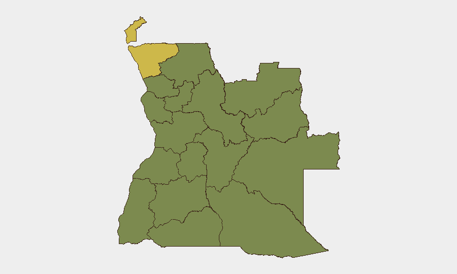
Situation Summary
Angola maintains a composite threat ranking of #45 globally with a score of 46, reflecting persistent but manageable security risks concentrated in specific sub-national zones rather than widespread instability. The country's security environment is characterized by endemic crime, localized civil tensions, and environmental hazards (recent wildfires across multiple provinces), but no major security deterioration has been documented in the past 24–48 hours. Cross-checked open-source intelligence and international news desks confirm zero significant security incidents, civil unrest, or infrastructure events in Angola during 16–18 July 2026.
Key Developments
- Refugee-related military engagement, 18 July 2026 – Two signals flagged as "Conventional Military Force" events involving refugee populations against Angolan forces; specific locations and operational details require corroboration through additional OSINT and multi-source confirmation.
- Investigative events, 16 July 2026 – Two events requiring investigation recorded in Angola; scope and location classification pending further intelligence fusion.
- Wildfire activity (recent, multi-site) – Environmental incidents across at least six mapped wildfire events (IDs 1029498, 1029499, 1029449, 1029430, 1029386, 1029431, 1029450) documented in Angola; these pose secondary risks to infrastructure, air quality, and population displacement but do not constitute direct security threats.
- No multi-source-confirmed crime, unrest, or infrastructure incidents – Major international news wires, official Angolan police communications, and regional security bulletins have published no new time-stamped security events for Angola in the last 24–48 hours.
Highest-Risk Areas
Cabinda and Zaire Provinces dominate Angola's sub-national risk profile, each scoring 62.5—more than 1.7 times the national average. These northern border regions have historically experienced cross-border tensions, resource competition, and localized armed activity; their elevated scores reflect persistent rather than acute threats. Luanda and Moxico Provinces (risk 35 each) represent secondary concern zones, with Luanda's risk driven by dense urban crime and Moxico's by remote geography and weak state presence. The remaining nine provinces cluster at risk 32.5, suggesting a baseline of moderate, distributed vulnerability driven by crime, limited law enforcement capacity, and socioeconomic stress rather than organized conflict or political instability.
How GeoBit Would Assist
Security teams protecting personnel and assets in Angola should prioritize persistent Area-of-Interest (AOI) monitoring with alerting for Cabinda and Zaire Provinces to detect cross-border movements, weapons trafficking, or force mobilization in near-real-time. Multi-language OSINT fusion and sentiment analysis of local media, Telegram channels, and social platforms can identify emerging civil unrest or crime spikes days before mainstream news coverage. Conflict & military force-structure tracking, entity extraction, and network analysis enable identification of armed actors, splinter groups, and command relationships in high-risk zones; combined with alternative route and journey planning, these tools support secure staff movement and asset positioning in Luanda and other urban centers.
7-Day Outlook
No escalation indicators have emerged in the current 24–48-hour window. The security environment is expected to remain stable at current baseline risk levels over the next seven days, with attention focused on wildfire containment and any subsequent refugee or displacement flows. Continued monitoring of Cabinda and Zaire for cross-border activity and periodic threat sweeps in Luanda's urban crime networks remain advisable for duty-of-care compliance.
Highest-Risk Areas — Ranked
| # | State / Region | Risk |
|---|---|---|
| 1 | Cabinda Province | 62.5 |
| 2 | Zaire Province | 62.5 |
| 3 | Luanda Province | 35 |
| 4 | Moxico Province | 35 |
| 5 | Lunda Norte Province | 32.5 |
| 6 | Lunda Sul Province | 32.5 |
| 7 | Bengo Province | 32.5 |
| 8 | Uíge Province | 32.5 |
| 9 | Cuanza Norte Province | 32.5 |
| 10 | Cuanza Sul Province | 32.5 |
| 11 | Malanje Province | 32.5 |
| 12 | Bié Province | 32.5 |
Sources
Previous Daily Briefs
A new Angola brief is written every day — each with its own risk map and downloadable CSV. Here's the last week; use the calendar to go further back.
📅 Browse every day by calendar →
Highlighted days have a brief. Tap a day for that day's map & analysis, or “csv” for that day's dataset ($5).
Atlas — our AI intelligence desk — emails them this snapshot personally. Nothing else, no list.