Situation Summary
Angola remains at composite threat rank #47 globally with 1,012 tracked events, reflecting persistent baseline risks rather than acute security deterioration. No significant security incidents were confirmed in the last 24–48 hours; however, multiple active wildfires across the country and ongoing refugee-related military activity warrant monitoring. The security environment is characterized by chronic resource-sector tensions, petty and organized crime, and health risks, with no evidence of imminent escalation in the capital or major economic zones.
Key Developments
- Refugee-military engagement (2026-07-18): Two confirmed conventional military force events involving refugee populations vs. Angolan forces were recorded on 2026-07-18; specific location and casualty details remain under analysis.
- Wildfire activity (ongoing, multi-province): At least 10 active wildfires are tracked across Angola, including incidents in Benguela, Cuando Cubango, Cunene, and Luanda provinces; no immediate threat to major urban centers reported, but fire response diverts state resources.
- Flood response operations (recent, Benguela/Luanda region): Flood-related activity has been reported in Benguela, Cuando Cubango, Cunene, and Luanda; impact on infrastructure and displacement status requires continued monitoring but are not classified as acute security events.
Highest-Risk Areas
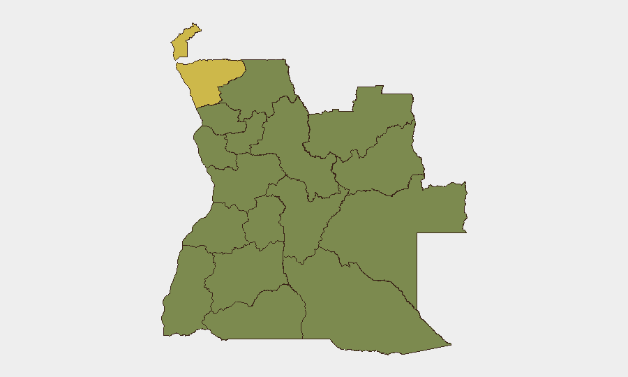
Cabinda and Zaire provinces dominate the sub-national risk ranking (62.9 each), driven by long-standing separatist tensions, border permeability, and resource competition. A second tier of 10 provinces (Lunda Norte, Lunda Sul, Bengo, Luanda, Uíge, Cuanza Norte, Cuanza Sul, Malanje, Bié, and Moxico) all register 32.9 risk score, reflecting baseline criminal activity, diamond-sector vulnerabilities, and limited state capacity in remote areas. Luanda Province, despite inclusion in the secondary tier, remains the operational hub for multinational corporations and diplomatic missions; security there is more resilient but petty crime and organized theft remain chronic concerns.
How GeoBit Would Assist
Security teams operating in Angola should employ AOI Monitoring & Early Warning to establish persistent watches on Cabinda and Zaire provinces, where refugee movements and military activity may signal escalation. Conflict & Military force-structure and weapons-capability tracking, combined with Network & Actor Analysis, would support identification of key armed groups and their operational patterns in the diamond-mining regions. Environmental & Health monitoring, integrated with GIS & Spatial Analysis, can track wildfire spread and flood impact on supply chains and personnel movement corridors in real time.
7-Day Outlook
No acute deterioration is forecast for the next seven days, assuming refugee military engagements remain contained and do not spread beyond border zones. Wildfires and flood recovery operations will continue to strain provincial resources and may temporarily disrupt road access in affected areas; companies with logistics operations should plan contingencies. Baseline crime and resource-sector tension will persist; duty-of-care protocols should remain in effect for all field personnel in Cabinda, Zaire, and remote mining provinces.
Highest-Risk Areas — Ranked
| # | State / Region | Risk |
|---|---|---|
| 1 | Cabinda Province | 62.9 |
| 2 | Zaire Province | 62.9 |
| 3 | Lunda Norte Province | 32.9 |
| 4 | Lunda Sul Province | 32.9 |
| 5 | Bengo Province | 32.9 |
| 6 | Luanda Province | 32.9 |
| 7 | Uíge Province | 32.9 |
| 8 | Cuanza Norte Province | 32.9 |
| 9 | Cuanza Sul Province | 32.9 |
| 10 | Malanje Province | 32.9 |
| 11 | Bié Province | 32.9 |
| 12 | Moxico Province | 32.9 |
Previous Daily Briefs
A new Angola brief is written every day — each with its own risk map and downloadable CSV. Here's the last week; use the calendar to go further back.
📅 Browse every day by calendar →
Highlighted days have a brief. Tap a day for that day's map & analysis, or “csv” for that day's dataset ($5).
Atlas — our AI intelligence desk — emails them this snapshot personally. Nothing else, no list.