Situation Summary
Benin remains under persistent terrorism and kidnapping threats in its northern border departments, but no major security incidents have been confirmed in the last 24–48 hours. The country's composite threat score of 30 places it outside the global top tier, and current web monitoring shows no credible reports of active conflict, mass civil unrest, or infrastructure disruption as of 3 August 2026. Risk remains concentrated in the north; southern and coastal zones continue to experience routine law-enforcement activity and localized crime.
Key Developments
No verifiable major security incidents have been confirmed for Benin in the last 24–48 hours (2–3 August 2026) across open sources, social media, or news outlets. Standing alerts from the German Foreign Office and other governments continue to warn against travel within 50 km of northern borders due to repeated attacks on security forces and civilians, but these represent ongoing advisories rather than fresh incidents. Routine police and customs operations against explosives trafficking, counterfeit medicines, and urban crime continue in northern corridors (Sonahoulou–Djougou axis, Malanville region) and major cities (Cotonou, Parakou), consistent with June 2026 reporting patterns.
Highest-Risk Areas
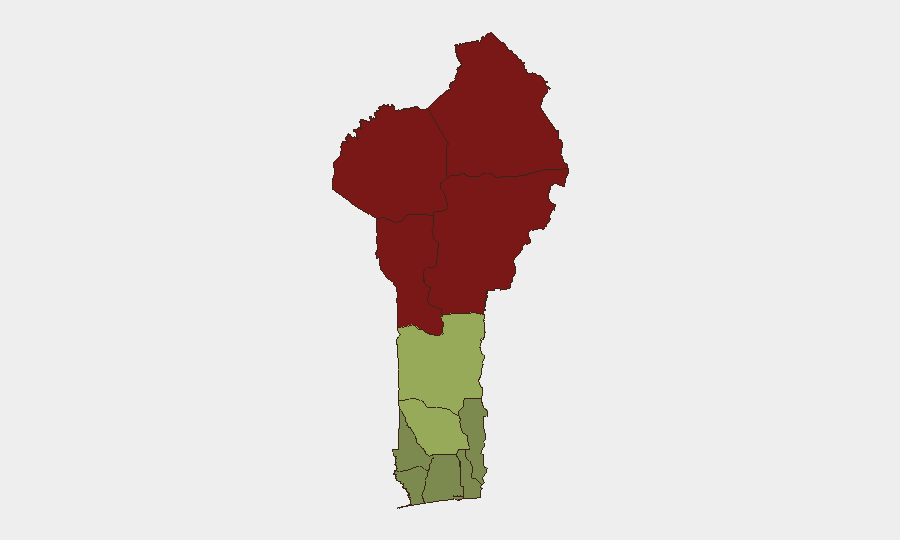
Alibori, Atakora, Donga, and Borgou departments in the far north drive Benin's composite threat score; these border regions face sustained terrorism and kidnapping risk from jihadist groups operating across the Sahel, with repeated attacks on security personnel and civilians documented since at least mid-2026. A sharp risk cliff separates the northern tier (scores 83–92) from central and southern departments (Zou, Collines, Plateau at 38–45), reflecting the geographic concentration of transnational militant activity. The coastal and southern zones (Atlantique, Littoral, Ouémé) register substantially lower risk (22–28), indicating that threat exposure is almost entirely a northern phenomenon tied to porous borders and weak state presence in remote areas.
How GeoBit Would Assist
Corporate security teams operating in Benin should use AOI Monitoring & Early Warning to establish persistent watch on northern departments (Alibori, Atakora, Borgou) and border checkpoints, generating automated alerts when terrorism, kidnapping, or armed-group activity emerges. Intel Sweep and multi-language OSINT fusion across news, social media, and Telegram channels will surface credible incident reports and claim patterns before they reach mainstream outlets, enabling faster duty-of-care response and personnel movement decisions. Routing & Network Analysis can identify security-vetted travel corridors and alternative routes avoiding high-risk northern zones for personnel or asset movement.
7-Day Outlook
Northern threat levels are expected to remain elevated and consistent with the standing advisory posture; seasonal patterns and border permeability suggest no imminent major escalation, but opportunistic kidnappings and armed encounters with security forces remain credible. Southern and coastal operations should proceed under routine security discipline. Continued monitoring of regional jihadist claims and cross-border activity in Niger and Burkina Faso will be essential to anticipate any sudden shift in Benin's northern security environment.
Highest-Risk Areas — Ranked
| # | State / Region | Risk |
|---|---|---|
| 1 | Alibori Department | 92 |
| 2 | Atakora Department | 88 |
| 3 | Donga Department | 85 |
| 4 | Borgou Department | 83 |
| 5 | Zou Department | 45 |
| 6 | Collines Department | 42 |
| 7 | Plateau Department | 38 |
| 8 | Kouffo Department | 35 |
| 9 | Mono Department | 32 |
| 10 | Atlantique Department | 28 |
| 11 | Littoral | 25 |
| 12 | Ouémé Department | 22 |
Sources
Previous Daily Briefs
A new Benin brief is written every day — each with its own risk map and downloadable CSV. Here's the last week; use the calendar to go further back.
📅 Browse every day by calendar →
Highlighted days have a brief. Tap a day for that day's map & analysis, or “csv” for that day's dataset ($5).
Atlas — our AI intelligence desk — emails them this snapshot personally. Nothing else, no list.