Situation Summary
Bolivia's composite threat score of 45 places it at #49 globally, with 119 tracked events indicating moderate but active instability. Signal data from 2–3 July shows clustering around government-directed demonstrations, arrests, and civil disapproval, concentrated in La Paz and secondary urban centers. The country faces overlapping pressures from labor and civic mobilization, criminal activity, and political tension, with no imminent state collapse but persistent operational friction for corporate and diplomatic presence.
Key Developments
- 2026-07-03 · Arrest/Detain (Bolivia): Unspecified detentions recorded; likely linked to protest or political activity. Location and subject matter require verification via local law enforcement and media sources.
- 2026-07-03 · Demonstrate/Rally (Bolivia vs Government): Multiple protest/rally events recorded against government; no specific location, casualty, or blockade duration confirmed in available signals. Cross-reference with La Paz, El Alto, and Cochabamba municipal sources for scope.
- 2026-07-03 · Disapprove (Bolivia vs Criminal): Civic or state disapproval action tied to criminal activity; insufficient detail to assess targeting or geographic extent.
- 2026-07-01 · Disapprove (Bolivia): General disapproval event; limited signal granularity.
- 2026-07-01–02 · Regional spillover: Brazilian disapproval signal linked to Bolivia suggests potential cross-border labor, trade, or migration tension; monitor bilateral relations and border-region activity.
- Diplomatic activity (non-security): Bolivian delegation traveled to Tehran for Iranian state funeral (early July); routine diplomatic engagement with no domestic security implication.
Note: Event signals indicate protest and law-enforcement activity but lack specifics on scale, location, casualties, or infrastructure impact. Confirmation through local Bolivian media (Página Siete, La Razón, Los Tiempos, El Deber) and official statements from Ministerio de Gobierno and relevant gobernaciones is essential before operational decisions are made.
Highest-Risk Areas
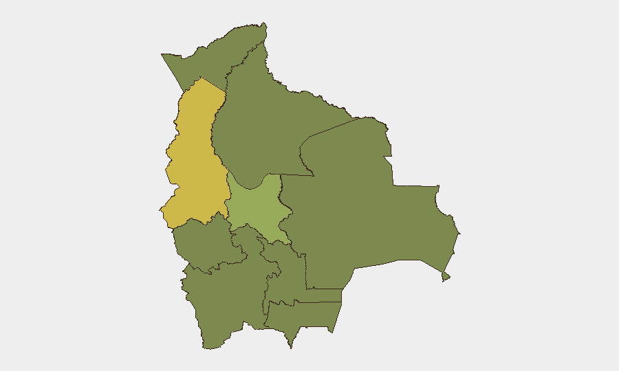
La Paz dominates the risk landscape (61.7), reflecting capital-city concentration of political activity, civil unrest, and law-enforcement response. Cochabamba (41.9) ranks second, historically a focal point for labor, indigenous, and civic mobilization. The remaining departamentos—Potosí, Tarija, Pando, Beni, Oruro, Chuquisaca, and Santa Cruz—cluster at 31.7–32.4, indicating baseline but elevated chronic risk rather than acute crisis. Risk concentration in La Paz and secondary urban centers suggests that corporate and diplomatic operations in those zones face higher exposure to disruption, protest, and security-force activity than remote or rural areas.
How GeoBit Would Assist
Security teams should deploy AOI Monitoring & Early Warning on La Paz and Cochabamba with alerts configured for protest, blockade, and law-enforcement keywords in Spanish (bloqueo, movilización, enfrentamientos, paro cívico). Intel Sweep and multi-language X/Twitter & Telegram OSINT provide real-time detection of emerging civil unrest, roadblocks, and official restrictions 24–48 hours ahead of peak impact. GIS & Spatial Analysis and Routing & Network Analysis enable identification of safe corridors and alternative transportation routes around active demonstration zones, critical for duty-of-care compliance during mobility operations.
7-Day Outlook
Demonstration and disapproval signals suggest ongoing civic and political friction through early July, with La Paz and Cochabamba likely remaining focal points. No indicators of armed escalation, security-force breakdown, or state collapse are present; however, cumulative protest activity and potential roadblocks may disrupt supply chains and personnel movement. Continuous monitoring of government statements, labor-union activity, and road-blockade reports is warranted to anticipate operational constraints by mid-week.
Highest-Risk Areas — Ranked
| # | State / Region | Risk |
|---|---|---|
| 1 | La Paz | 61.7 |
| 2 | Cochabamba | 41.9 |
| 3 | Potosí | 32.4 |
| 4 | Tarija | 31.7 |
| 5 | Pando | 31.7 |
| 6 | Beni | 31.7 |
| 7 | Oruro | 31.7 |
| 8 | Chuquisaca | 31.7 |
| 9 | Santa Cruz | 31.7 |
Previous Daily Briefs
A new Bolivia brief is written every day — each with its own risk map and downloadable CSV. Here's the last week; use the calendar to go further back.
📅 Browse every day by calendar →
Highlighted days have a brief. Tap a day for that day's map & analysis, or “csv” for that day's dataset ($5).