Situation Summary
Burkina Faso remains at Global Risk Rank #14 (composite threat score 78), with insurgency as the primary driver. As of 30 June 2026, the government controlled 74.53% of national territory—a modest 0.97 percentage-point gain from December 2025—indicating a stabilizing but still contested security environment. No clearly verified kinetic attacks or major incidents have been independently documented in the last 24–48 hours; current threat posture reflects ongoing high-level risks (curfews, checkpoints, movement restrictions, and persistent terrorist and kidnapping threats) rather than fresh escalation.
Key Developments
- Territorial control update (reported 25 July 2026, measured 30 June 2026): Defence ministry reported government control at 74.53% of national territory as of 30 June, up from 73.56% in December 2025—a marginal but measurable advance in contested areas, primarily in Centre region and surrounding zones. This remains the most recent official status statement, though it reflects control measured three weeks prior to the brief date.
- Diplomatic consular access (ongoing, Ouagadougou): French embassy services closure continues to affect foreign nationals' access to emergency consular support and evacuation assistance. No reopening has been reported in the last 48 hours.
- Travel advisories (current as of late July 2026): Ireland's Department of Foreign Affairs and Germany's Federal Foreign Office maintain highest-level travel warnings citing volatile political conditions, closed land borders, limited international flights, and credible risks of terrorist attacks and kidnappings targeting foreigner-frequented locations.
- Security incident reporting gap (assessment dated 23 July 2026): Independent security sources note absence of newly verified significant kinetic attacks in the 48 hours preceding 23 July, consistent with lower recent incident-reporting volume but indicating no discrete new event in the immediate 24–48 hour window.
- Nationwide curfew and checkpoint operations (status ongoing): Curfews and movement restrictions remain in force across high-risk regions; checkpoints continue to constrain civilian and commercial mobility, particularly in Centre, North, East, and Sahel regions.
Highest-Risk Areas
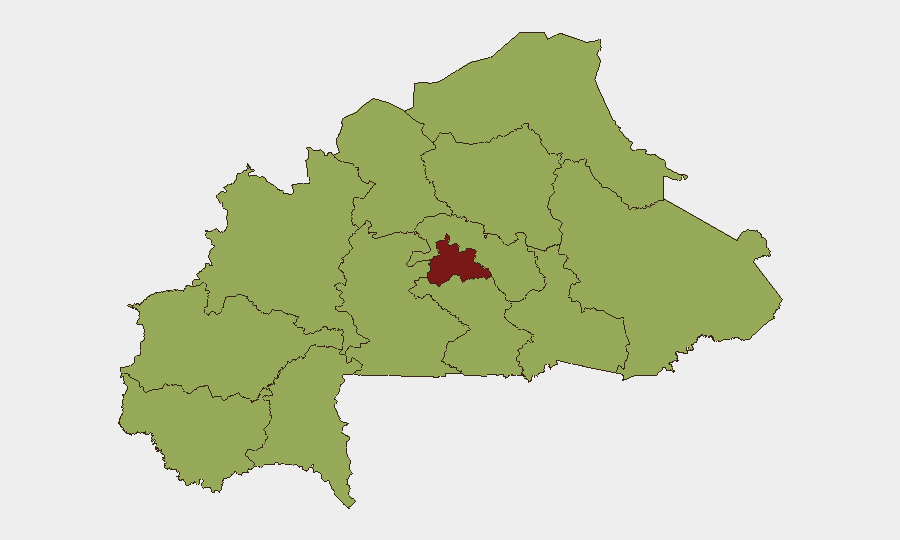
Centre region (risk score 84.8) drives national threat ranking and remains the epicentre of insurgent activity and government counter-operations. The nine next-highest-risk regions—Upper-Basins, Boucle du Mouhoun, Central-West, Central-South, Central-East, Waterfalls, Southwest, Sahel, Central-North, East, and North—all register at 54.8, indicating a broad, multi-region threat belt that constrains government territorial consolidation. This tier-two clustering reflects diffuse insurgent presence and sporadic cross-regional operational activity rather than a single conflict zone, complicating both force deployment and civilian mobility planning.
How GeoBit Would Assist
Security teams can deploy AOI Monitoring & Early Warning on Centre region and the tier-two risk zones to detect upticks in militant activity, checkpoints, or curfew extensions before they affect planned operations. Intel Sweep with OSINT fusion across X/Twitter, local news, and radio SIGINT enables real-time corroboration of reported incidents and rapid validation of rumour versus confirmed threat. Routing & Network Analysis supports alternative journey planning for personnel and supply chains to avoid high-risk corridors and dynamic checkpoint concentrations.
7-Day Outlook
Government territorial gains remain incremental; no imminent large-scale kinetic escalation is signalled in available reporting, but the broad dispersion of tier-two risk zones suggests continued low-level militant activity, sporadic clashes, and checkpoint friction across multiple regions. Consular access limitations and restrictive travel advisories will persist absent diplomatic normalization; security posture is likely to remain static to slightly restrictive over the next week.
Highest-Risk Areas — Ranked
| # | State / Region | Risk |
|---|---|---|
| 1 | Centre | 84.8 |
| 2 | Upper-Basins | 54.8 |
| 3 | Boucle du Mouhoun | 54.8 |
| 4 | Central-West | 54.8 |
| 5 | Central-South | 54.8 |
| 6 | Central-East | 54.8 |
| 7 | Waterfalls | 54.8 |
| 8 | Southwest | 54.8 |
| 9 | Sahel | 54.8 |
| 10 | Central-North | 54.8 |
| 11 | East | 54.8 |
| 12 | North | 54.8 |
Sources
Previous Daily Briefs
A new Burkina Faso brief is written every day — each with its own risk map and downloadable CSV. Here's the last week; use the calendar to go further back.
📅 Browse every day by calendar →
Highlighted days have a brief. Tap a day for that day's map & analysis, or “csv” for that day's dataset ($5).
Atlas — our AI intelligence desk — emails them this snapshot personally. Nothing else, no list.