Situation Summary
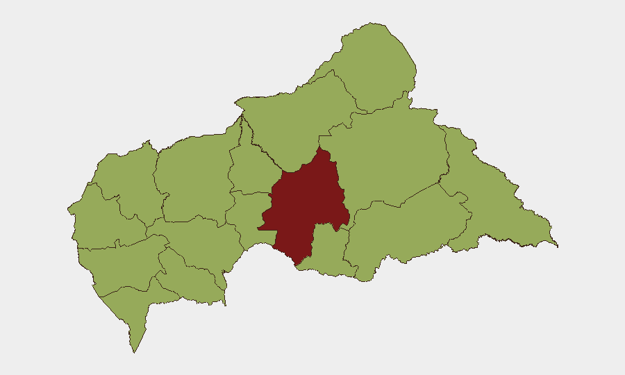
Central African Republic remains a fragmented security environment with an overall composite threat ranking of 79 (rank #30 globally). The most significant recent incident—a coordinated armed attack on a Zambian MINUSCA patrol in Vakaga Prefecture on 30 June—underscores persistent gaps in force protection and active armed group capabilities in remote northeastern prefectures. Ouaka Prefecture continues to register the highest sub-national risk (85), while eleven other prefectures cluster at elevated risk (55), indicating geographically distributed instability rather than single-point concentration. Current trajectory reflects chronic rather than acute deterioration, but localized flashpoints demand sustained monitoring.
Key Developments
- Am Dafok, Vakaga Prefecture (30 June–2 July 2026): An unidentified armed group attacked a Zambian Battalion MINUSCA patrol with small arms, RPGs, and machine-gun fire, resulting in multiple casualties among peacekeepers, civilians, and Gendarmerie. A Sri Lanka Air Force MINUSCA aviation unit evacuated 14 wounded by helicopter to Birao and Bria medical facilities on 1–2 July in response to the incident.
- Central Bank–Banking Sector Tensions (ongoing, 30 June–2 July 2026): Multiple enforcement and disapproval signals between the Central Bank and commercial banking entities, including sanctions, investigations, and public statements directed at both banks and the population, suggest regulatory or liquidity friction in the financial system.
- Constitutional and Electoral Dispute (1 July 2026): The Central Election Commission issued a disapproval action against the Constitutional Court, signaling institutional friction over electoral or constitutional matters, though details remain sparse in available reporting.
- Regional Diplomatic Cooling (30 June 2026): Ghana, Nigeria, and Uganda each reduced relations with the Democratic Republic of Congo, primarily signaling regional concern over DRC stability or conduct; secondary spillover effects on CAR remain unclear but warrant monitoring given border proximity and militant movement patterns.
- Iranian Investigation Signal (30 June 2026): An investigation signal attributed to Iran appeared in event feeds; context and scope are not yet clear from open sources and require further corroboration.
Highest-Risk Areas
Ouaka Prefecture (risk 85) stands significantly above all other administrative divisions and should be the primary sub-national focus; it accounts for the steepest concentration of risk drivers. Vakaga and the eastern tier (Bamingui-Bangoran, Haute-Kotto, Haut-Mbomou, Mbomou) form a secondary high-risk corridor along the Chad and South Sudan borders, where Am Dafok's recent attack demonstrates active armed-group presence and limited state control. The southern prefectures (Mambéré-Kadéï, Sangha-Mbaéré, Nana-Mambéré) and central-western zones cluster at identical risk levels (55), reflecting broad exposure to armed-group activity, criminal networks, and resource competition rather than a single dominant threat axis.
How GeoBit Would Assist
Security and duty-of-care teams should deploy Area-of-Interest (AOI) Monitoring & Early Warning on Ouaka and the eastern prefectures to detect armed-group movement and attack signals with minimal latency. Conflict & Military mapping combined with Network & Actor Analysis would identify armed-group force structures, leadership, and likely axes of advance or targeting. Satellite & Imagery analysis of key supply routes, transit nodes, and populated centers, layered with OSINT fusion of open-source reporting and radio SIGINT, provides early indication of attack preparation or personnel movement in remote areas where conventional intelligence is sparse.
7-Day Outlook
No immediate escalation to state-level military collapse or capital-area instability is indicated. Armed-group activity in Vakaga and Ouaka will likely continue at current operational tempo—small-unit attacks on convoys and checkpoints—with periodic MINUSCA casualties. Financial and institutional tensions (Central Bank actions, electoral friction) may create secondary governance friction but are unlikely to trigger acute security deterioration within seven days.
Highest-Risk Areas — Ranked
| # | State / Region | Risk |
|---|---|---|
| 1 | Ouaka | 85 |
| 2 | Bamingui-Bangoran | 55 |
| 3 | Vakaga | 55 |
| 4 | Haute-Kotto | 55 |
| 5 | Haut-Mbomou | 55 |
| 6 | Mbomou | 55 |
| 7 | Nana-Mambéré | 55 |
| 8 | Ouham-Pendé | 55 |
| 9 | Mambéré-Kadéï | 55 |
| 10 | Sangha-Mbaéré | 55 |
| 11 | Ouham | 55 |
| 12 | Nana-Grébizi | 55 |
Sources
Previous Daily Briefs
A new Central African Republic brief is written every day — each with its own risk map and downloadable CSV. Here's the last week; use the calendar to go further back.
📅 Browse every day by calendar →
Highlighted days have a brief. Tap a day for that day's map & analysis, or “csv” for that day's dataset ($5).