Situation Summary
Chad remains a moderate-tier global security concern (rank #27, composite score 80) with persistent sub-national fragmentation and cross-border pressure. The threat environment is driven primarily by activity in the Sahel and eastern border zones rather than capital-region instability. As of 10 July 2026, no major kinetic incidents have been confirmed in Chad proper during the last 24–48 hours, though regional spillover from Sudan's Darfur conflict and Libya border volatility continues to create displacement and secondary risk.
Key Developments
- Eastern Chad / Darfur transit zones (10 Jul) — ICC Deputy Prosecutor Nazhat Shameem Khan conducted community engagement visits in eastern Chad related to the ongoing Darfur situation investigation; this represents sustained international attention to conflict-affected populations but does not indicate new violence inside Chad.
- Chad–Libya border region (ongoing) — Two abduction and hostage incidents involving Chadian nationals were reported near the border (reported 2 Jul); trafficking and kidnapping remain endemic to remote border areas.
- Sudan–Chad displacement corridor (10 Jul) — Renewed RSF attacks in Sudan's Darfur region are driving flight toward Chad, particularly affecting refugee settlement areas in eastern states; cross-border displacement creates humanitarian strain and secondary security risk.
- Multiple physical assault events (10 Jul) — Two separate physical assault incidents were flagged in GeoBit signals across Chad on 10 July; circumstances and locations remain under verification.
- Public expressions of discontent (10 Jul) — Public statements, appeals, and disapproval events were recorded on 10 July; sentiment analysis is ongoing to assess grievance severity and geographic distribution.
- Health monitoring — Hepatitis E activity continues to circulate in Chad; disease surveillance remains a parallel risk factor affecting workforce availability and humanitarian operations.
Highest-Risk Areas
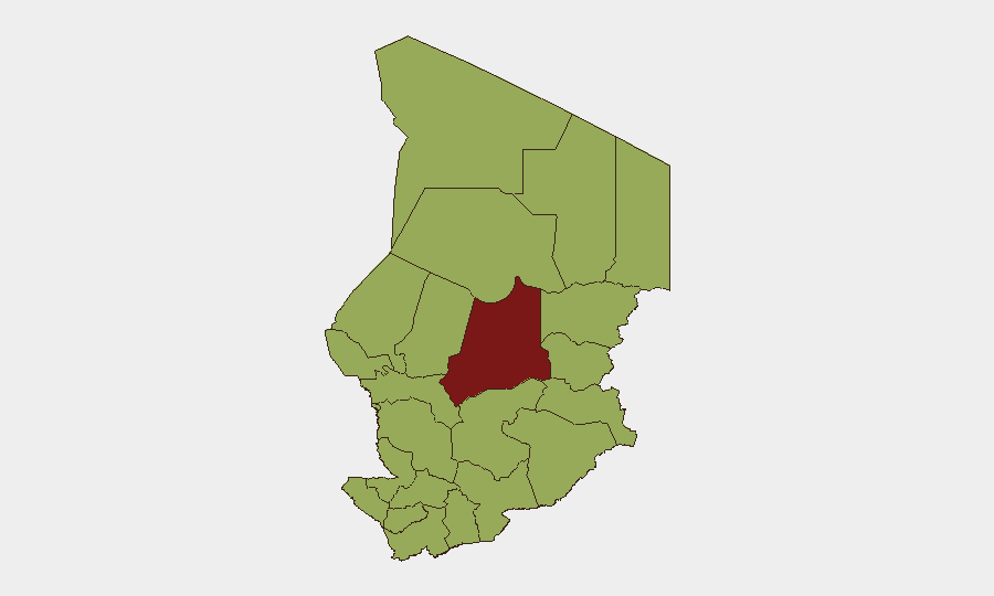
Batha (85.7) stands significantly above other regions and represents the composite peak for insecurity, likely reflecting its position as a Sahel-front state with arms trafficking, banditry, and cross-border militant activity. The cluster of nine regions (Ennedi-Ouest through Chari-Baguirmi, all scoring 55.7) reflects a broad band of elevated but more uniform risk spanning the northeast, east, and central zones—driven by refugee influx, porous borders, criminal networks, and weak local state capacity. N'Djamena (55.7) scores within this second tier despite being the capital, indicating urban-crime, protest, and social-tension drivers rather than organized insurgency. Remote northeast and eastern states (Ennedi, Sila, Ouaddaï, Wadi Fira) merit particular vigilance for abduction, trafficking, and militant activity.
How GeoBit Would Assist
Security teams with personnel or assets in Chad should deploy Area-of-Interest (AOI) Monitoring & Early Warning on Batha, Ennedi-Ouest, and eastern border zones to detect militant movement, trafficking, or displacement surges in real time. OSINT fusion (X/Telegram monitoring, radio SIGINT, and multi-language feeds) will surface early indicators of group activity, recruitment, or resource movement that precede kinetic events. Conflict & Military battle mapping paired with Routing & Network Analysis enables duty-of-care teams to plan safe movement corridors and identify network vulnerabilities affecting staff or supply lines.
7-Day Outlook
The near-term trajectory remains stable with no imminent indicators of capital-region destabilization or major escalation inside Chad proper. Sustained RSF pressure in Darfur and Libya border volatility will likely continue to drive refugee inflow and informal-economy stress in eastern states; this typically manifests as rising banditry and intercommunal friction rather than organized political upheaval. Batha and the northeast remain the zones requiring sustained monitoring for any tactical shifts in militant positioning or cross-border incursions.
Highest-Risk Areas — Ranked
| # | State / Region | Risk |
|---|---|---|
| 1 | Batha | 85.7 |
| 2 | Ennedi-Ouest | 55.7 |
| 3 | Wadi Fira | 55.7 |
| 4 | Ouaddaï | 55.7 |
| 5 | Sila | 55.7 |
| 6 | Salamat | 55.7 |
| 7 | East Ennedi | 55.7 |
| 8 | Kanem | 55.7 |
| 9 | Lac | 55.7 |
| 10 | N'Djamena | 55.7 |
| 11 | Hadjer-Lamis | 55.7 |
| 12 | Chari-Baguirmi | 55.7 |
Sources
Previous Daily Briefs
A new Chad brief is written every day — each with its own risk map and downloadable CSV. Here's the last week; use the calendar to go further back.
📅 Browse every day by calendar →
Highlighted days have a brief. Tap a day for that day's map & analysis, or “csv” for that day's dataset ($5).
Atlas — our AI intelligence desk — emails them this snapshot personally. Nothing else, no list.