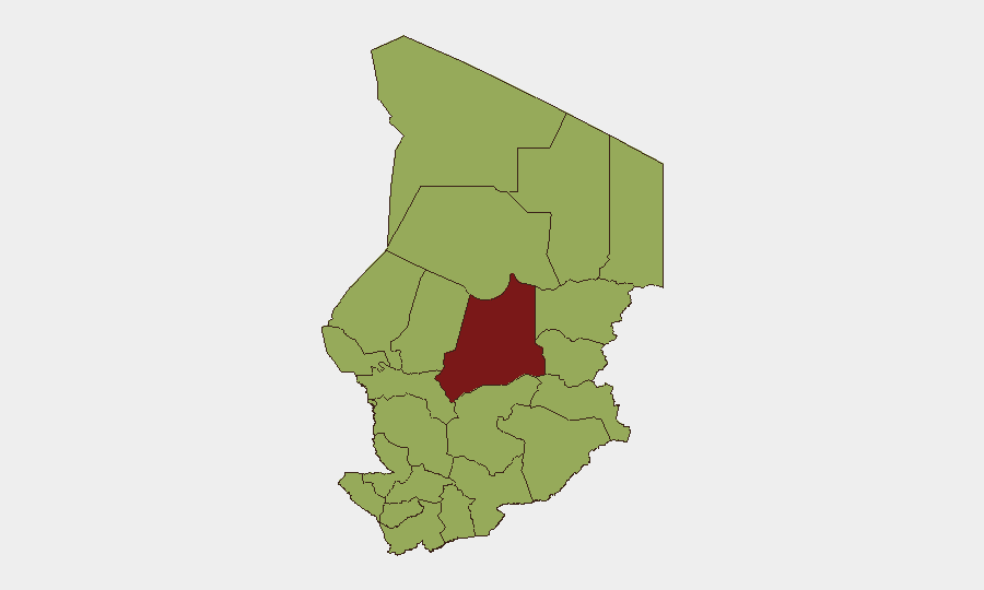
Situation Summary
Chad remains at moderate operational risk (composite threat score 80; rank #28 globally) with persistent sub-national armed group activity, militia incursions, and intercommunal tensions across the Sahel and eastern regions. Over the last 24–48 hours, no independently corroborated major armed clashes, terrorist attacks, large-scale protests, or critical infrastructure disruptions have been reported. The threat environment is best characterized as a volatile baseline rather than an acute crisis, though the absence of reported incidents should not be interpreted as genuine stabilization.
Key Developments
- No significant new security incidents reported (11–13 July 2026). Cross-checked open-source feeds (Reuters Africa, Africanews, France24) and independent monitoring confirm no major verified events in the last 24–48 hours.
- Multi-lateral conventional military activity flagged (14 July 2026). GeoBit event signals indicate multiple instances of conventional military force activity involving Chad, Niger, Cameroon, and Nigeria on 14 July; corroboration and specificity of these signals remain pending verification through ongoing OSINT fusion.
- Hepatitis E case activity noted (recent). Health surveillance indicates Hepatitis E circulation in-country; epidemiological scope and geographic spread remain under assessment.
- Arrest/detention event recorded (14 July 2026). A detainment event attributed to Chadian authorities is flagged; operational context and individuals involved require further clarification.
- Gang-affiliated conventional military activity (13 July 2026). Non-state armed group military activity was reported; geographic location and casualty/displacement data are under review.
Highest-Risk Areas
Batha region stands as the single highest-risk area (composite score 86.1), reflecting concentrated armed group presence and intercommunal tensions. Eleven additional regions—spanning Ennedi-Ouest, Wadi Fira, Ouaddaï, Sila, Salamat, East Ennedi, Kanem, Lac, N'Djamena, Hadjer-Lamis, and Chari-Baguirmi—each carry a composite risk score of 56.1, indicating a broad geographic distribution of threat across the north, east, and capital region. This risk profile reflects persistent militia activity, transnational armed group infiltration, and limited state security capacity across multiple sub-national zones rather than risk concentrated in a single pocket.
How GeoBit Would Assist
For teams with personnel or assets in Chad, GeoBit's AOI Monitoring & Early Warning capability provides persistent watch over high-risk sub-national zones (Batha, border regions) with real-time alerting on armed group movement or intercommunal violence. Conflict & Military tools (battle mapping, force-structure tracking, weapons-capability assessment) and Network & Actor Analysis enable tracking of non-state armed actors and militia networks across the country. Intel Sweep and multi-language OSINT fusion (including X, Telegram, local radio SIGINT, and cross-border open-source feeds) deliver corroborated situational awareness where official reporting is sparse, reducing exposure to unverified claims or reporting delays.
7-Day Outlook
Near-term trajectory remains stable at current baseline risk levels; no imminent shift to acute crisis is evident from available indicators. Monitoring of multi-lateral military activity and gang-affiliated force deployments should be sustained, and staff in Batha and eastern border regions (Ennedi, Wadi Fira, Ouaddaï) should maintain heightened situational awareness. Health teams should track Hepatitis E epidemiology and coordinate with local health authorities for case reporting and outbreak containment.
Highest-Risk Areas — Ranked
| # | State / Region | Risk |
|---|---|---|
| 1 | Batha | 86.1 |
| 2 | Ennedi-Ouest | 56.1 |
| 3 | Wadi Fira | 56.1 |
| 4 | Ouaddaï | 56.1 |
| 5 | Sila | 56.1 |
| 6 | Salamat | 56.1 |
| 7 | East Ennedi | 56.1 |
| 8 | Kanem | 56.1 |
| 9 | Lac | 56.1 |
| 10 | N'Djamena | 56.1 |
| 11 | Hadjer-Lamis | 56.1 |
| 12 | Chari-Baguirmi | 56.1 |
Sources
Previous Daily Briefs
A new Chad brief is written every day — each with its own risk map and downloadable CSV. Here's the last week; use the calendar to go further back.
📅 Browse every day by calendar →
Highlighted days have a brief. Tap a day for that day's map & analysis, or “csv” for that day's dataset ($5).
Atlas — our AI intelligence desk — emails them this snapshot personally. Nothing else, no list.