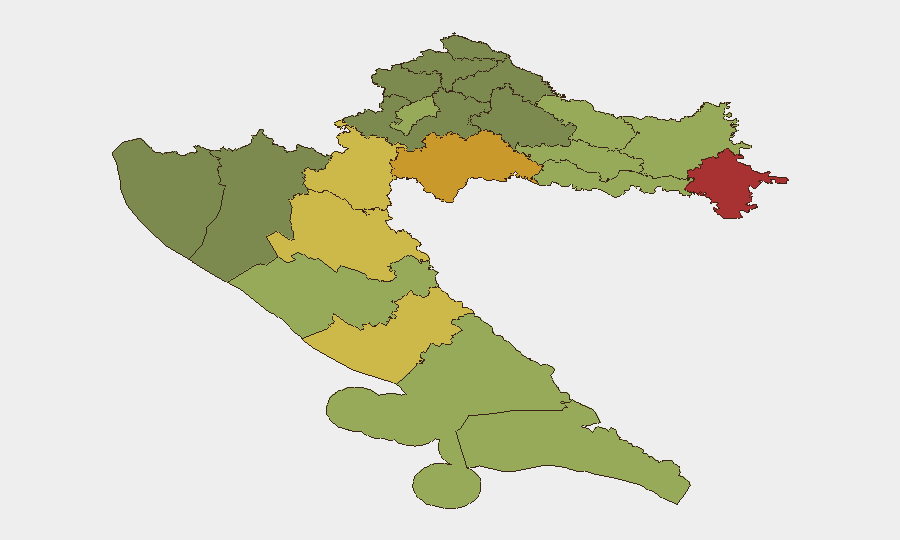
Situation Summary
Croatia maintains a composite threat score of 4, placing it in the lower-risk tier globally. The country has recorded 3 tracked events within the assessment window, with no significant security incidents reported in the last 24–48 hours. Eastern border regions and former conflict zones continue to exhibit elevated risk profiles relative to coastal and central areas, reflecting persistent infrastructure vulnerabilities and residual tensions.
Key Developments
GeoBit's web research for the last 24–48 hours yielded no independently corroborated discrete security incidents meeting publication threshold. A hydrogen sulfide contamination alert near Rijeka's Orada Adriatic facility (late July 2026) triggered a police inquiry, but timestamp precision is insufficient to confirm occurrence within the current 48-hour window. Unconfirmed local police reports reference road accidents, theft, fire, and assault across unnamed locations, but lack specific dates required for current-window classification. No travel disruptions, border incidents, civil unrest, or infrastructure failures were substantiated for 2–3 August 2026.
Highest-Risk Areas
Eastern continental counties—Vukovar-Srijem (78), Sisak-Moslavina (72), and Karlovac (68)—dominate the risk ranking, reflecting post-conflict legacy vulnerabilities including aging infrastructure, limited emergency services, and socioeconomic stress. These regions abut or overlap with former warzone terrain and remain subject to periodic unexploded ordnance discovery and environmental contamination incidents. Lika-Senj and Šibenik-Knin counties (65, 62) show similar patterns. By contrast, Zagreb and Split-Dalmatia (50, 48) record lower risk, correlating with higher development density, law-enforcement presence, and tourism-driven security investment. Teams with personnel or assets in Vukovar-Srijem and Sisak-Moslavina should maintain heightened situational awareness and verify local emergency-service accessibility.
How GeoBit Would Assist
Intel Sweep and multi-language OSINT provide real-time monitoring of local Croatian news, police reports, and social-media signals to identify incidents before wider circulation. AOI (Area-of-Interest) Monitoring & Early Warning allows persistent watch on Vukovar-Srijem, Sisak-Moslavina, and other high-risk counties, triggering alerts on infrastructure failures, hazmat incidents, or civil unrest. Routing & Network Analysis enables security teams to plan alternate travel routes avoiding known contamination zones or congested incident areas. Environmental & Health data integration flags industrial incidents (e.g., Rijeka hydrogen sulfide alert) in near-real time, supporting duty-of-care compliance for staff near port or chemical-facility proximity.
7-Day Outlook
No indicators suggest a deterioration in Croatia's security posture over the next seven days. Seasonal summer tourism peaks may elevate minor crime (petty theft, road incidents) in coastal zones, but organized violence, civil unrest, or border instability remain low-probability. Eastern counties warrant continued passive monitoring for infrastructure incidents and environmental hazards; no escalation is anticipated absent external geopolitical shock.
Highest-Risk Areas — Ranked
| # | State / Region | Risk |
|---|---|---|
| 1 | Vukovar-Srijem County | 78 |
| 2 | Sisak-Moslavina County | 72 |
| 3 | Karlovac County | 68 |
| 4 | Lika-Senj County | 65 |
| 5 | Šibenik-Knin County | 62 |
| 6 | Brod-Posavina County | 58 |
| 7 | Zadar County | 55 |
| 8 | Osijek-Baranja County | 52 |
| 9 | City of Zagreb | 50 |
| 10 | Split-Dalmatia County | 48 |
| 11 | Požega-Slavonia County | 45 |
| 12 | Virovitica-Podravina County | 42 |
Sources
Previous Daily Briefs
A new Croatia brief is written every day — each with its own risk map and downloadable CSV. Here's the last week; use the calendar to go further back.
📅 Browse every day by calendar →
Highlighted days have a brief. Tap a day for that day's map & analysis, or “csv” for that day's dataset ($5).
Atlas — our AI intelligence desk — emails them this snapshot personally. Nothing else, no list.