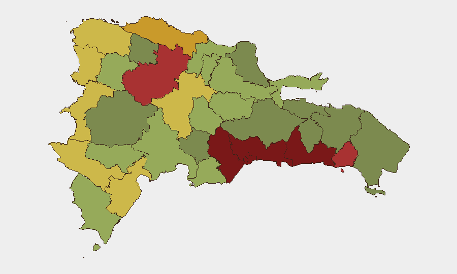
Situation Summary
The Dominican Republic faces routine but elevated crime and enforcement activity, with no nationwide instability or large-scale conflict. Public-order incidents—localized protests, targeted police operations, and border-enforcement sweeps—remain geographically dispersed and manageable. The security environment is characterized by chronic crime in urban centers (Santo Domingo, Santiago) and intensified migration enforcement across border provinces, creating short-term friction but not systemic breakdown.
Key Developments
- Haina, Santo Domingo province (last 1–2 days): Hospital-conditions protests at Barsequillo Hospital drew police presence and local media attention; residents and staff voiced grievances over precarious infrastructure and inadequate services. Movement and access around the facility may be disrupted.
- Santiago de los Caballeros (last 24–48 hours): Fatal traffic collision between a sports car and motorcycle killed two people, including a one-year-old child; police investigation ongoing into speeding and negligence. Localized road disruptions and heightened traffic enforcement likely near the incident site.
- Barahona province (last 24–48 hours): Policía Nacional executed two robbery arrest warrants in Los Solares de Milton; seized 232 grams of mixed narcotics at Calle Capitólio; dismantled a clandestine alcohol factory in Cabral with multiple fermentation tanks confiscated. Short-term police activity and potential retaliatory crime risk in these neighborhoods.
- La Ciénaga, Paraíso, Enriquillo, Barahona province (recent Thursday morning): An unidentified foreign citizen died during coordinated all-night raids by Policía Nacional and Ministerio Público, reportedly following a collapse after an altercation. Incident raises reputational and diplomatic sensitivities around foreign-resident treatment during enforcement operations.
- Border provinces—Montecristi, Elías Piña, Valverde (last reporting window): Army patrols (ERD) intercepted 37 Haitian nationals in three separate operations at Loma de Solimán, rural routes near Las Matas de Farfán, and Los Restauradores (Mao); transferred to migration authorities. Routine but ongoing checkpoints and movement disruptions expected in rural border areas.
- Nationwide migration operations (culminating 29 July, ongoing effects): Dirección General de Migración (DGM) reported 800 deportations and 955 detentions across Santo Domingo, Pedernales, La Vega, Elías Piña, La Altagracia, Barahona, Dajabón, Santiago, and other provinces. Heightened document checks and detention risk for individuals without proper status, especially near border and transit corridors.
- National police-conduct scrutiny (last few days): President demanded transparent justice in the killing of Darlin Mercado by officer José Francisco Moreta Heredia (officer now under pretrial detention request). Potential for localized protests or social-media-driven demonstrations if case is perceived as mishandled.
- International airport (current week): Authorities seized 90 cocaine packages and arrested two terminal workers in a joint security and anti-narcotics operation. Further inspections and screening delays probable for travelers.
Highest-Risk Areas
Santo Domingo (risk 92) and Nacional District (risk 88) dominate the threat landscape, driven by urban crime concentration, gang activity, and enforcement operations. San Cristóbal, San Pedro de Macorís, and La Romana follow, reflecting ongoing narcotics trafficking, robbery networks, and migration-related activity. Border provinces—Elías Piña (70), Dajabón (68)—rank elevated due to irregular migration flows, smuggling routes, and military/police enforcement sweeps. The top-risk urban centers remain the primary concern for corporate assets and personnel.
How GeoBit Would Assist
Security teams should deploy AOI Monitoring & Early Warning on Santo Domingo, Santiago, and border provinces to track real-time police operations, detention sweeps, and protest activity. OSINT fusion (X/Twitter, local media, police press releases) enables continuous horizon-scanning for emerging enforcement posture or civil-unrest triggers. Routing & Network Analysis helps identify alternate routes and checkpoints during migration enforcement operations or localized disruptions.
7-Day Outlook
Enforcement operations—police raids, migration sweeps, and airport security—will likely persist at current tempo through the near term. Hospital and labor-related protests may flare in urban centers if grievances are not addressed. Overall trajectory remains volatile but contained; no indicators of systemic escalation.
Highest-Risk Areas — Ranked
| # | State / Region | Risk |
|---|---|---|
| 1 | Santo Domingo | 92 |
| 2 | Nacional District | 88 |
| 3 | San Cristóbal | 85 |
| 4 | San Pedro de Macorís | 83 |
| 5 | La Romana | 78 |
| 6 | Santiago | 76 |
| 7 | Puerto Plata | 72 |
| 8 | Elías Piña | 70 |
| 9 | Dajabón | 68 |
| 10 | Barahona | 65 |
| 11 | Independencia Province | 64 |
| 12 | La Vega | 62 |
Sources
Previous Daily Briefs
A new Dominican Republic brief is written every day — each with its own risk map and downloadable CSV. Here's the last week; use the calendar to go further back.
📅 Browse every day by calendar →
Highlighted days have a brief. Tap a day for that day's map & analysis, or “csv” for that day's dataset ($5).
Atlas — our AI intelligence desk — emails them this snapshot personally. Nothing else, no list.