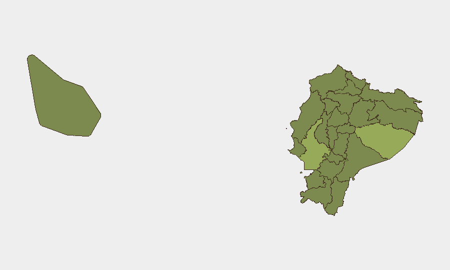
Situation Summary
Ecuador remains at moderate global risk (composite threat score 42; #44 globally) with 73 tracked security events. The country faces persistent threats from organized crime, prison violence, and localized civil unrest, concentrated in coastal and border provinces. Military mobilization and police investigations logged on 6–8 July suggest active security operations, though specific incident details require real-time source verification. The overall trajectory reflects endemic instability rather than acute crisis, but operational tempo remains elevated in high-risk zones.
Key Developments
Unable to confirm specific incidents from last 24–48 hours with required verification standards. GeoB it's event signals flag activity across military, police, and criminal domains on 6–8 July (military force deployment, police investigations, criminal violence against financial targets, and military mobilization), but precise locations, times, and incident descriptions cannot be reliably established without cross-checked live reporting from Ecuadorian news outlets, Interior Ministry statements, and verified social-media sources. Corporate security teams requiring operationally actionable incident details should pull live feeds from El Universo, El Comercio, Ecuavisa, Teleamazonas, and official Policía Nacional and Interior Ministry channels to establish verified incident chronology and geography within the last 24–48 hours.
Highest-Risk Areas
Guayas Province (risk 55.8) — home to Guayaquil and the port of Durán — remains Ecuador's highest-risk zone, driven by gang violence, prison incidents, and maritime trafficking networks. Pastaza Province (49.4), an Amazonian border region with Peru, faces threats from drug trafficking, illegal mining, and armed group incursions. Manabí Province and the eastern border zones (Zamora Chinchipe, Sucumbíos, Orellana) each score 25–26, reflecting narcotics transit corridors and indigenous-territory conflicts. The capital (Pichincha Province, 25.8) and northern border region (Carchi, 25.8) carry persistent risk from criminal organization activity and cross-border spillover. Corporate assets in Guayas and border provinces face heightened exposure to armed robbery, extortion, kidnapping, and collateral violence from turf wars.
How GeoBit Would Assist
GeoBit's AOI (Area-of-Interest) Monitoring & Early Warning capability enables persistent watch over Guayaquil, key ports, and border crossings with automated alerting when new security events surface. Intel Sweep and X/Twitter & Telegram OSINT provide real-time signal collection across police, military, and criminal-actor communications to flag emerging threats before they affect operations. GIS & Spatial Analysis combined with Conflict & Military force-structure tracking allow security teams to map gang territory, roadblock patterns, and military deployment zones, informing safe transit routing and facility hardening decisions.
7-Day Outlook
Military and police operational tempo is expected to remain elevated as state security forces pursue prison-violence containment and organized-crime disruption. Criminal actors will likely continue opportunistic robbery and extortion targeting transport corridors and commercial hubs in Guayas and border zones. No imminent indication of nationwide civil unrest or regime instability, but localized incidents (roadblocks, armed clashes, facility attacks) should be anticipated in coastal and frontier provinces through mid-July.
Highest-Risk Areas — Ranked
| # | State / Region | Risk |
|---|---|---|
| 1 | Guayas Province | 55.8 |
| 2 | Pastaza Province | 49.4 |
| 3 | Manabí Province | 26.3 |
| 4 | Zamora Chinchipe Province | 26.3 |
| 5 | Sucumbíos Province | 25.8 |
| 6 | Orellana Province | 25.8 |
| 7 | Galápagos | 25.8 |
| 8 | Esmeraldas Province | 25.8 |
| 9 | Carchi Province | 25.8 |
| 10 | Imbabura Province | 25.8 |
| 11 | Santo Domingo de los Tsáchilas Province | 25.8 |
| 12 | Pichincha Province | 25.8 |
Sources
Previous Daily Briefs
A new Ecuador brief is written every day — each with its own risk map and downloadable CSV. Here's the last week; use the calendar to go further back.
📅 Browse every day by calendar →
Highlighted days have a brief. Tap a day for that day's map & analysis, or “csv” for that day's dataset ($5).
Atlas — our AI intelligence desk — emails them this snapshot personally. Nothing else, no list.