Situation Summary
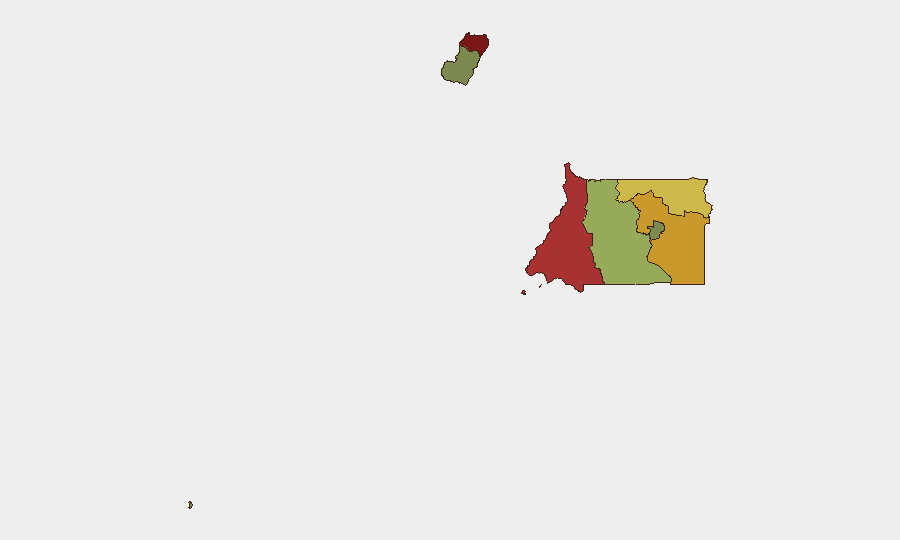
Equatorial Guinea remains a low-frequency threat environment (global rank #164, composite score 5) with no confirmed security incidents in the last 24–48 hours. The country's baseline risk profile is dominated by localized crime, weak institutional capacity, and periodic governance challenges rather than active conflict or organized violence. Sub-national risk concentrations in Bioko Norte and Litoral Province reflect persistent vulnerabilities in law enforcement, port security, and informal economy activity; these areas warrant elevated monitoring for corporate and expatriate personnel.
Key Developments
No discrete security, conflict, crime, or infrastructure incidents have been corroborated by multiple open sources for Equatorial Guinea during 28–29 August 2026. Recent open-source reporting has focused on U.S. deportation operations using Malabo as a transit point, but those events predate the current 24–48-hour window and represent migration policy rather than in-country security developments.
Recommendation: GeoBit's monitoring detected no actionable alerts in the standard incident window. Teams with operations in high-risk provinces (Bioko Norte, Litoral) should rely on standing liaison protocols and real-time AOI monitoring rather than event-driven alerts for this reporting cycle.
Highest-Risk Areas
Bioko Norte (risk 85) and Litoral Province (risk 78) account for the majority of sub-national threat concentration, driven by port-related contraband activity, limited police capacity, and informal settlement crime. Wele-Nzas Province (72) and Kié-Ntem Province (68)—both bordering Cameroon and Gabon—carry elevated cross-border smuggling and human-trafficking risk. Centro Sur, Bioko Sur, and the capital district Djibloho present substantially lower risk profiles; Annobón Province remains the most secure area. For corporate teams, risk scales with operational footprint in northern provinces and port facilities.
How GeoBit Would Assist
AOI Monitoring & Early Warning with persistent watch of ports (Luba, Bata, Malabo) and border crossings (Kié-Ntem, Wele-Nzas) would enable duty-of-care teams to detect smuggling operations, labor trafficking, or cross-border instability before they escalate to security incidents. Multi-language OSINT and X/Twitter/Telegram intelligence feeds targeting Spanish- and French-language regional media, local officials, and diaspora networks would fill current coverage gaps and improve near-real-time incident detection. Network & Actor Analysis of informal economy nodes and criminal networks in high-risk provinces supports contextual risk assessment for site security and personnel movement planning.
7-Day Outlook
No significant escalation in baseline threat is anticipated over the next seven days. Seasonal patterns and regional stability (absence of spillover from Cameroon or Gabon) suggest continuity in low-frequency, localized crime and governance challenges. Teams should maintain standing protocols; no heightened alert is warranted absent new intelligence.
GeoBit Assessment Date: 29 August 2026 | Confidence: Medium (open-source coverage of Equatorial Guinea is limited; absence of reported incidents does not confirm absence of activity)
Highest-Risk Areas — Ranked
| # | State / Region | Risk |
|---|---|---|
| 1 | Bioko Norte | 85 |
| 2 | Litoral Province | 78 |
| 3 | Wele-Nzas Province | 72 |
| 4 | Kié-Ntem Province | 68 |
| 5 | Centro Sur Province | 45 |
| 6 | Bioko Sur | 38 |
| 7 | Djibloho | 15 |
| 8 | Annobón Province | 8 |
Sources
Previous Daily Briefs
A new Equatorial Guinea brief is written every day — each with its own risk map and downloadable CSV. Here's the last week; use the calendar to go further back.
- August 26, 2026
- August 24, 2026
- August 22, 2026
- August 20, 2026
- August 18, 2026
- August 16, 2026
- August 14, 2026
📅 Browse every day by calendar →
Highlighted days have a brief. Tap a day for that day's map & analysis, or “csv” for that day's dataset ($5).
Atlas — our AI intelligence desk — emails them this snapshot personally. Nothing else, no list.