Situation Summary
Eritrea remains a low-frequency, moderate-baseline threat environment (global rank #70, composite score 24) with no discrete security incidents recorded in the current 24-48-hour window. However, the country's broader regional posture is influenced by adjacent conflict dynamics in Ethiopia–Tigray and Sudan, particularly cross-border military activity and allegations of Eritrean force deployment into northern Ethiopia. The most volatile zones are concentrated in the western and southern border regions; the capital region (Maekel) presents substantially lower risk.
Key Developments
- Alleged Eritrean military deployment into Tigray (2026-08-06): Horn Review reporting claimed Eritrean military assets, including heavy armor and tanks, were repositioned into northern Ethiopia/Tigray; independent corroboration from a second source within the last 48 hours was not available in supplied results.
- Airspace closure affecting commercial aviation (2026-08-05): Eritrean state media reported closure of Eritrean and Sudanese airspace to Ethiopian Airlines, cited as security-related; follow-on independent confirmation not present in current search window.
- Western Tigray border fighting near Eritrea's operational sphere (2026-08-10–11): Renewed combat in Shererina, western Tigray near the Sudan–Ethiopia border, involved TPLF-linked and ENDF forces; not an in-country Eritrea event, but proximate to Eritrea's strategic environment and potential spillover zones.
- Cross-border official contact claims (2026-08-06): Ethiopian state reporting alleged recent contact between Eritrean officials and former TPLF military figures in Tigray, framed as militarization concern; no independent confirmation in 24-48-hour window.
- Ongoing financial dispute (standing issue): Ethiopian Airlines revenue continues to be frozen in Eritrea due to political dispute; not a new 48-hour incident, but a persistent cross-border economic friction point affecting commercial operations.
Highest-Risk Areas
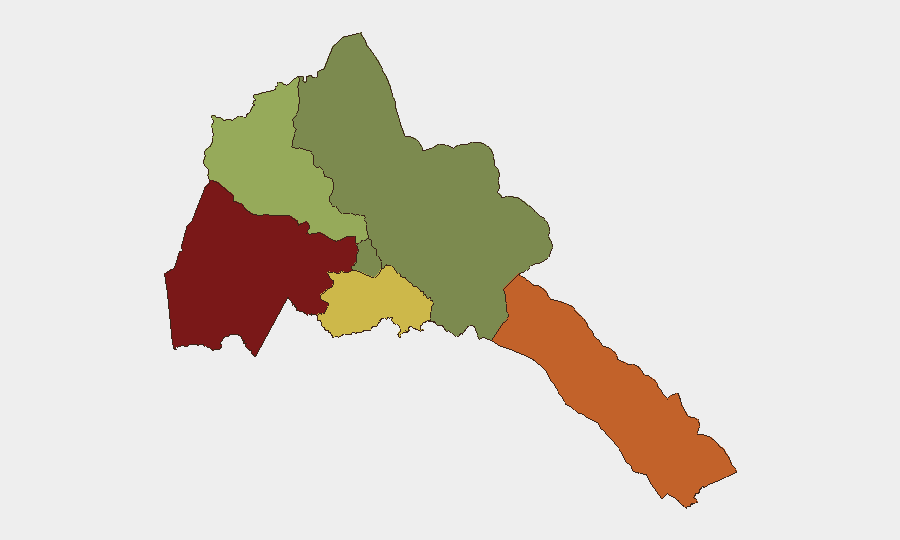
Gash-Barka (risk 92) and Southern Red Sea Region (risk 75) dominate Eritrea's threat landscape, driven by proximity to Sudan conflict spillover, semi-arid border permeability, and historical trafficking/militia activity. Debub Region (risk 68) carries secondary exposure to Ethiopian border instability. By contrast, Maekel Region (risk 18), which includes the capital Asmara, remains substantially lower-risk, reflecting stronger state control and lower cross-border exposure. Northern Red Sea Region registers minimal tracked risk.
How GeoBit Would Assist
Corporate teams with personnel or assets in Eritrea should prioritize Intel Sweep and multi-language OSINT to detect early warning of cross-border military movement or airspace/border restrictions before they disrupt operations. Satellite and imagery analysis, combined with conflict battle mapping and force-structure tracking, would provide real-time visibility on Eritrean military repositioning near Ethiopia and Sudan. AOI monitoring with alerting on Gash-Barka and Southern Red Sea Region, coupled with routing and network analysis, enables duty-of-care teams to update travel and supply-chain contingencies as conditions shift.
7-Day Outlook
No imminent domestic security escalation is forecast for Eritrea itself over the next seven days. However, sustained regional instability in Ethiopia–Tigray and Sudan, combined with unconfirmed reports of Eritrean military activity, creates a medium baseline of cross-border friction. Monitor for further airspace restrictions, cross-border force movements, and any formal military announcements from Asmara.
Highest-Risk Areas — Ranked
| # | State / Region | Risk |
|---|---|---|
| 1 | Gash-Barka | 92 |
| 2 | Southern Red Sea Region | 75 |
| 3 | Debub Region | 68 |
| 4 | Anseba | 55 |
| 5 | Maekel Region | 18 |
| 6 | Northen Red Sea Region | 0 |
Sources
Previous Daily Briefs
A new Eritrea brief is written every day — each with its own risk map and downloadable CSV. Here's the last week; use the calendar to go further back.
📅 Browse every day by calendar →
Highlighted days have a brief. Tap a day for that day's map & analysis, or “csv” for that day's dataset ($5).
Atlas — our AI intelligence desk — emails them this snapshot personally. Nothing else, no list.