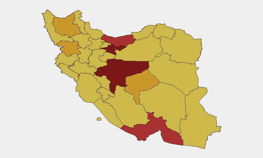
Situation Summary
Iran is experiencing active, multi-domain kinetic conflict with U.S. and allied forces in the Gulf region as of June 28–29, 2026, driven by an escalating cycle of tanker attacks, airstrikes, and cross-border missile/drone strikes. The immediate trigger—Iranian drone attacks on commercial shipping in the Strait of Hormuz—prompted U.S. Central Command airstrikes on Iranian military infrastructure in Hormozgan Province, followed by Iranian retaliation against U.S. facilities in Kuwait and Bahrain. Trajectory is toward sustained regional tension, with the IRGC enforcing new shipping restrictions in the Strait that heighten collision risk between Iranian forces and international commerce.
Key Developments
- Hormozgan Province (Sirik, Qeshm Island) – June 28, 2026: U.S. Central Command conducted airstrikes targeting approximately 10 Iranian military sites, including missile/drone storage, air defense, coastal radar, and communications infrastructure. Iranian state media confirmed explosions near Tahrui village and Qeshm Island, indicating direct kinetic impacts on coastal military installations.
- Strait of Hormuz – June 27–28, 2026: U.S. strikes explicitly framed as retaliation for Iranian IRGC drone attack on commercial tanker (*Kiku*/Ever Lovely); part of ongoing pattern of Iranian attacks on non-Iranian-controlled shipping.
- Kuwait – June 28, 2026 (early morning): IRGC claimed missile and drone strikes against U.S. military sites. Kuwaiti authorities confirmed interception of two Iranian ballistic missiles with no reported casualties or infrastructure damage.
- Bahrain – June 28, 2026 (early morning): Iran announced drone and missile strikes on U.S. naval target; Bahrain Interior Ministry confirmed Iranian munitions struck residential building near Bahrain International Airport, causing damage but no deaths.
- Strait of Hormuz (IRGC announcement) – June 27–28, 2026: IRGC publicly mandated that all vessels use Iranian-designated traffic lanes and coordinate with Iranian authorities; declared alternative routes "unacceptable," effectively threatening enforcement action against non-compliant shipping.
- Gulf region (multi-site pattern) – June 28, 2026: Confirmed at least second consecutive day of U.S. strikes on Iranian targets and Iranian retaliation against U.S.-linked facilities, establishing pattern of tit-for-tat escalation rather than isolated incident.
Highest-Risk Areas
Tehran Province (risk 100) and Isfahan Province (risk 97.1) drive national risk primarily as command-and-control and decision-making centers; however, operational threat is concentrated in southern coastal and maritime zones: Hormozgan Province (77.8) is the active kinetic zone, hosting IRGC naval bases and missile/drone facilities now under direct U.S. targeting. Ilam, Khuzestan, and Yazd Provinces (70.2–71.7) reflect spillover risk from cross-border IRGC activity and potential for secondary strikes. Northern border regions (Kurdistan, East Azerbaijan, Gilan) show elevated risk consistent with ongoing Kurdish insurgency and historical cross-border militant activity, but are secondary to current Gulf-focused conflict.
How GeoBit Would Assist
Security teams protecting personnel or assets in Iran should employ Battle Mapping and Conflict tracking to monitor real-time strike patterns and IRGC positioning; Maritime & Aviation tracking to monitor Strait of Hormuz shipping corridors and assess compliance risk with new Iranian routing mandates; and AOI Monitoring with Early Warning to receive alerts on new kinetic events, regime statements, or force movements in Tehran, Isfahan, and Hormozgan Provinces. Alternative Route/Journey Planning and Sentiment & Temporal Analysis (via X/Telegram OSINT) provide near-real-time situational awareness of escalation signals and civilian movement advisories.
7-Day Outlook
Current trajectory favors continued low-intensity strikes and counter-strikes over next 48–72 hours, with highest risk in Hormozgan and along Strait shipping lanes. Likelihood of broader regional escalation or direct Iranian strikes on mainland U.S./allied territory remains elevated if either side interprets a strike as crossing a critical red line; maritime insurance and logistics disruption will remain acute. De-escalation window exists but is narrow and dependent on diplomatic signaling not yet visible in available reporting.
Highest-Risk Areas — Ranked
| # | State / Region | Risk |
|---|---|---|
| 1 | Tehran Province | 100 |
| 2 | Isfahan Province | 97.1 |
| 3 | Mazandaran Province | 78.5 |
| 4 | Hormozgan Province | 77.8 |
| 5 | Kurdistan Province | 72.7 |
| 6 | Yazd Province | 71.7 |
| 7 | East Azerbaijan Province | 71 |
| 8 | Ilam Province | 70.4 |
| 9 | Kohgiluye and Buyer Ahmad Province | 70.4 |
| 10 | Fars Province | 70.3 |
| 11 | Gilan Province | 70.3 |
| 12 | Khuzestan Province | 70.2 |
Sources
Previous Daily Briefs
A new Iran brief is written every day — each with its own risk map and downloadable CSV. Here's the last week; use the calendar to go further back.
📅 Browse every day by calendar →
Highlighted days have a brief. Tap a day for that day's map & analysis, or “csv” for that day's dataset ($5).