Situation Summary
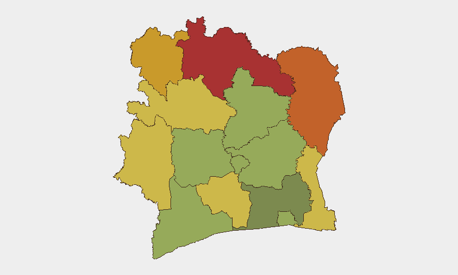
Ivory Coast remains at low global risk (rank #86, composite score 15) with no verified security incidents, civil unrest, armed conflict, or acute travel disruptions reported in the past 24–48 hours. However, risk is heavily concentrated in the northern frontier districts (Savanes, Zanzan, Denguélé, Comoé), where transnational trafficking, cross-border armed activity, and communal tensions persist. The national security posture remains stable; Abidjan and southern commercial zones continue normal operations.
Key Developments
- No new verified incidents reported across Ivory Coast in the 24–48 hour window (28–30 July 2026). Open-source monitoring channels consistent with GeoBit's regional feeds show no corroborated reports of security events, crime spikes, infrastructure disruptions, or political instability requiring immediate alert.
- GEOBIT event signals flagged two recent signals: a public statement attributed to BARA vs. Ivory Coast (28 July) and a demand labeled to Côte d'Ivoire (30 July). These remain unconfirmed and lack corroborating detail; attribution, nature, and geographic scope require further intelligence clarification.
- Northern frontier zones remain endemic-risk areas. Savanes and Zanzan districts (risk scores 78, 75) continue to experience the highest baseline threat from trafficking networks, militant infiltration from Mali/Burkina Faso, and informal armed groups. No acute escalation is signaled in the current 48-hour window, but these areas warrant continuous monitoring.
- Abidjan and southern economic corridor stable. The capital and port zones (Bas-Sassandra, Gôh-Djiboua) remain operational with lower localized risk (scores 45–60), supporting continued commercial and industrial activity.
Highest-Risk Areas
Savanes, Zanzan, Denguélé, and Comoé districts collectively define Ivory Coast's risk profile, driven by proximity to Mali and Burkina Faso, porous borders, trafficking corridors (drugs, weapons, contraband), and intermittent militant or criminal group activity. These zones lack robust state presence and experience seasonal destabilization. By contrast, southern and central districts (Abidjan, Bassassandra, Vallée du Bandama) carry substantially lower risk and support the majority of foreign personnel and supply chains. Organizations with assets in the north should assume elevated baseline exposure; southern operations face routine commercial-crime and petty-security risks typical of West African urban/port environments.
How GeoBit Would Assist
AOI Monitoring & Early Warning on the high-risk northern districts would provide persistent watch for trafficking events, armed-group movement, or cross-border incursions. Intel Sweep, multi-language OSINT, and network-actor analysis would clarify the two flagged signals (BARA statement, Ivorian demand) and track non-state actor positioning. GIS and satellite imagery would support route-risk assessment for personnel or cargo transiting northern roads, enabling alternative-journey planning to avoid hot zones.
7-Day Outlook
No acute escalation is forecast for the next seven days; national stability is expected to hold. However, the unconfirmed nature of the two recent signals warrants close monitoring—if either event correlates with cross-border militant activity or trafficking enforcement, northern-district risk could sharpen. Organizations should maintain standard duty-of-care protocols in high-risk zones and activate real-time alert subscriptions for any verified incident signals in Savanes, Zanzan, or Denguélé.
Highest-Risk Areas — Ranked
| # | State / Region | Risk |
|---|---|---|
| 1 | Savanes District | 78 |
| 2 | Zanzan District | 75 |
| 3 | Denguélé District | 72 |
| 4 | Comoé District | 70 |
| 5 | Montagnes District | 68 |
| 6 | Woroba District | 65 |
| 7 | Gôh-Djiboua District | 60 |
| 8 | Sassandra-Marahoué District | 58 |
| 9 | Vallée du Bandama District | 55 |
| 10 | Bas-Sassandra District | 52 |
| 11 | Lacs District | 48 |
| 12 | Abidjan | 45 |
Sources
Previous Daily Briefs
A new Ivory Coast brief is written every day — each with its own risk map and downloadable CSV. Here's the last week; use the calendar to go further back.
📅 Browse every day by calendar →
Highlighted days have a brief. Tap a day for that day's map & analysis, or “csv” for that day's dataset ($5).
Atlas — our AI intelligence desk — emails them this snapshot personally. Nothing else, no list.