Situation Summary
Lebanon remains in active conflict with a composite threat score of 74 (ranked #19 globally), driven primarily by military escalation and political instability. The past 72 hours have seen heightened diplomatic tensions, military mobilization, and cross-border threat signals involving Israel, Iran, and Lebanese state and non-state actors. The security environment is deteriorating along a trajectory of rejection and disapproval statements coupled with conventional military activity, indicating elevated risk of further escalation.
Key Developments
- 2026-07-05 · Israel–Lebanon disapproval statement – Formal diplomatic rejection signals ahead of potential military or policy action; no specific location or casualty toll reported as of briefing time.
- 2026-07-04 · Israel disapproves Lebanon Government position – Indicates policy or operational discord; timing aligns with broader regional tensions.
- 2026-07-03 · UNICEF threat incident – Humanitarian operations disrupted or endangered; specific location and severity unconfirmed pending corroboration.
- 2026-07-03 · Lebanese conventional military force mobilization – State armed forces deployed or repositioned; suggests defensive or offensive readiness but location not yet granular in available signals.
- 2026-07-03 · Iranian public statement on Lebanon – Foreign actor messaging; consistent with regional proxy dynamics and potential escalation signaling.
- 2026-07-02 · Lebanese artillery/tank activity – Confirmed weapons deployment; location unspecified, but indicates active military posture shift.
- 2026-07-02 · US rejection of Lebanon-related action – US diplomatic pushback; reflects broader great-power positioning in the conflict.
Highest-Risk Areas
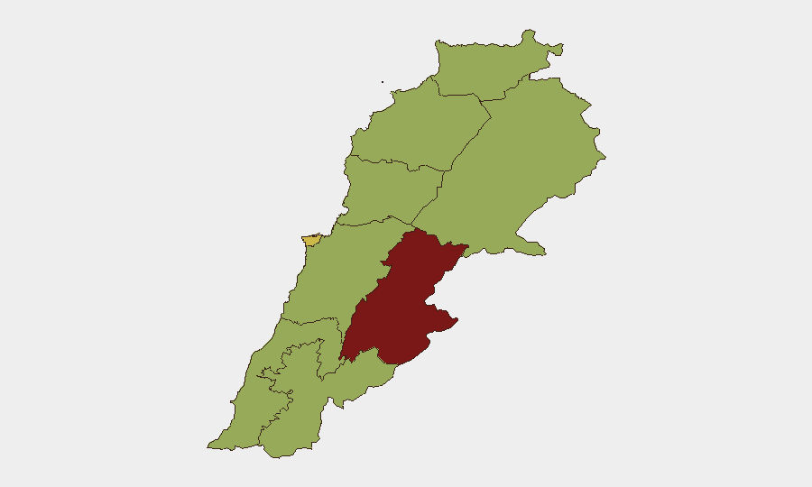
Beqaa Governorate emerges as the critical flashpoint (risk 82.1), significantly outpacing all other regions. This reflects its geography as a border zone, presence of armed groups, and history as a proxy-warfare corridor. Beirut (70) remains the second-highest concern due to concentration of state institutions, international presence, and civilian density. The remaining seven governorates cluster at 52.1, indicating baseline conflict risk across the country; however, South and Nabatieh governorates warrant particular attention given proximity to Israeli border and known militant infrastructure. Northern and coastal zones (Akkar, Keserwan-Jbeil, Mount Lebanon) face secondary but material risk from spillover and supply-chain disruption.
How GeoBit Would Assist
Teams with personnel or assets in Lebanon should deploy AOI Monitoring & Early Warning on Beqaa and Beirut with real-time alerting for military activity, weapons movements, and civilian incidents. Conflict & Military tracking (battle mapping, force structure, weapons-capability analysis) and Network & Actor Analysis would clarify alignment of armed groups, state forces, and foreign actors to anticipate targeting and movement. Intel Sweep (multi-language OSINT, X/Telegram monitoring, sentiment analysis) should run continuous feeds on parliamentary statements, Iranian and Israeli messaging, and community-level reporting to capture escalation signals 24–48 hours ahead of kinetic events.
7-Day Outlook
Cross-border tensions are likely to sustain or intensify over the next 7 days, with Israel–Lebanon diplomatic rejection preceding possible military probing or strikes. Lebanese military mobilization suggests state readiness but also potential miscalculation risk. Humanitarian access in Beqaa and South is forecast to remain constrained; asset movement and personnel rotation should assume 48–72 hour delays and alternate routing via Beirut or northern corridors.
Highest-Risk Areas — Ranked
| # | State / Region | Risk |
|---|---|---|
| 1 | Beqaa Governorate | 82.1 |
| 2 | Beirut Governorate | 70 |
| 3 | North Governorate | 52.1 |
| 4 | Akkar Governorate | 52.1 |
| 5 | Keserwan-Jbeil Governorate | 52.1 |
| 6 | Mount Lebanon Governorate | 52.1 |
| 7 | South Governorate | 52.1 |
| 8 | Nabatieh Governorate | 52.1 |
| 9 | Baalbek-Hermel Governorate | 52.1 |
Previous Daily Briefs
A new Lebanon brief is written every day — each with its own risk map and downloadable CSV. Here's the last week; use the calendar to go further back.
📅 Browse every day by calendar →
Highlighted days have a brief. Tap a day for that day's map & analysis, or “csv” for that day's dataset ($5).
Atlas — our AI intelligence desk — emails them this snapshot personally. Nothing else, no list.