Situation Summary
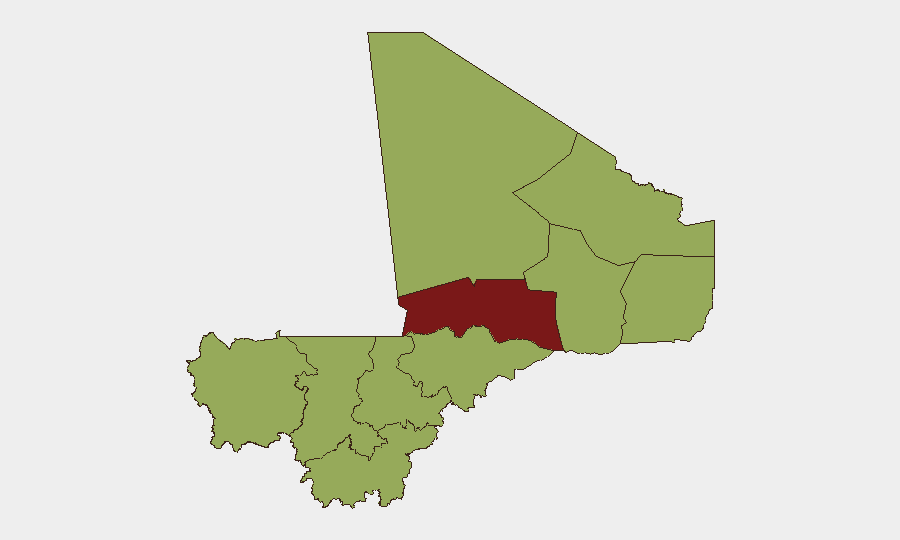
Mali remains at elevated national threat level (global rank #27, composite score 74) with persistent armed-group activity concentrated in the north and central regions. A tactical lull in verified armed clashes was reported over June 27–28, 2026, but this represents a temporary reduction in kinetic activity rather than genuine de-escalation. Structural drivers—fuel shortages, infrastructure strain, and junta-directed press controls—continue to constrain stability and civilian service access. The security environment is expected to remain volatile, with risk heavily concentrated in Timbuktu (81.7) and a second tier of northern and central regions all scoring 51.7.
Key Developments
- Countrywide, June 27–28, 2026 – tactical lull in armed clashes. Specialist security feeds report no independently verified armed clashes, tactical attacks, or infrastructure damage in the 48 hours prior to June 27; this lull is characterized as temporary and does not signal underlying de-escalation.
- Bamako, June 27–28, 2026 – detention and transnational legal activity. Multiple signals of arrest, detention, and threat activity tied to transnational criminal and diplomatic cases were recorded in official channels; specifics remain under review and are not confirmed as Mali-internal security incidents.
- Timbuktu, late June 2026 – ongoing utility disruption. Residents report approximately one week without reliable running water or electricity due to acute fuel shortages, a disruption that persists into late June and is likely to extend further without fuel supply restoration.
- Countrywide, late June 2026 – critical fuel shortage. Severe and continuing fuel shortages across Mali, including Bamako, are reducing essential services, lengthening queues at gas stations, and impairing transportation; shortages are confirmed as ongoing into late June.
- Bamako and northern regions, late June 2026 – ongoing press-control measures. Junta-directed arrests of journalists and suspensions of radio programs continue as part of sustained press-control operations; these represent a persistent pattern rather than a discrete recent incident.
Highest-Risk Areas
Timbuktu dominates the risk landscape at 81.7, driven by active armed-group presence, recurrent utility collapse, and limited state capacity. A second tier—Ménaka, Kayes, Taoudénit, Kidal, Gao, and central Ségou and Mopti—all score 51.7 and reflects both ongoing insurgent activity in the north and central corridor and criminal violence. Bamako, despite being the capital, scores equivalently (51.7) due to transnational criminal activity, junta security operations, and infrastructure vulnerability. The concentration of critical risk in the north and central-north corridor reflects the enduring influence of armed groups (JNIM, IS-affiliated factions) and the state's limited ability to deliver services or security in those zones.
How GeoBit Would Assist
Corporate security and duty-of-care teams should employ Intel Sweep and multi-language OSINT fusion to monitor Mali-specific event feeds and detect emerging kinetic activity before it reaches mainstream reporting; AOI Monitoring & Early Warning on critical nodes (Bamako fuel supply lines, Timbuktu utilities, Ségou–Mopti corridor) would provide persistent alerting on service disruption and armed-group movements. Routing & Network Analysis is essential for alternative journey planning around high-risk zones and for modeling fuel-supply vulnerability; Conflict & Military force-structure tracking helps identify which armed groups are active and capable of attack in each region.
7-Day Outlook
The current tactical lull is likely to be brief; historical patterns suggest renewed kinetic activity within 7–14 days. Fuel shortages will continue to degrade service provision and civilian movement, increasing tension and indirect security risks. Any fuel-supply corridor disruption or new armed-group statement would be the primary indicator of imminent escalation.
Highest-Risk Areas — Ranked
| # | State / Region | Risk |
|---|---|---|
| 1 | Timbuktu | 81.7 |
| 2 | Ménaka | 51.7 |
| 3 | Kayes | 51.7 |
| 4 | Taoudénit Region | 51.7 |
| 5 | Kidal | 51.7 |
| 6 | Gao | 51.7 |
| 7 | Bamako | 51.7 |
| 8 | Koulikoro | 51.7 |
| 9 | Ségou Region | 51.7 |
| 10 | Sikasso Region | 51.7 |
| 11 | Mopti | 51.7 |
Sources
Previous Daily Briefs
A new Mali brief is written every day — each with its own risk map and downloadable CSV. Here's the last week; use the calendar to go further back.
📅 Browse every day by calendar →
Highlighted days have a brief. Tap a day for that day's map & analysis, or “csv” for that day's dataset ($5).