Situation Summary
Myanmar remains in a state of protracted armed conflict with fragmented control across multiple regions, characterized by low-intensity clashes between military junta forces and armed opposition groups, along with significant humanitarian strain and displacement. The national threat ranking (#11 globally, composite score 100) reflects persistent multi-domain risks: conventional military operations, narcotics trafficking, digital suppression, and organized crime. As of 29 June 2026, open-source reporting indicates no major escalation or de-escalation in the last 24–48 hours; the conflict trajectory remains static at current operational tempo, with reporting lags limiting real-time visibility into tactical incidents.
Key Developments
Reporting Gap (27–28 June 2026): Open-source and social media channels currently do not provide clearly dated, verifiable security or conflict incidents for the last 24–48 hours. The most recent traceable incidents in public feeds are dated 23 June 2026 or earlier. Any attribution of specific events to 27–28 June would require speculation and would not meet fact-checking standards.
Context (Last 5–7 Days, For Situational Awareness):
- Magway Region drone strikes (mid-to-late June): Military Mi-17 helicopter and drone operations reported against opposition positions; specific tactical outcomes unclear from open sources.
- Chin State air operations (late June): Ongoing air campaigns by junta forces; civilian impact reports unverified in real-time feeds.
- Digital suppression (26 June reported): NGO and media-freedom groups documented internet throttling and social-media restrictions; scope and duration not yet fully detailed.
- Narcotics enforcement (late June): Regime conducted multi-state narcotics destruction ceremonies; trafficking routes and cartel activity patterns remain active despite seizures.
- Humanitarian displacement (ongoing): Low-level clashes and armed-group presence continue to drive internal displacement; IOM and UNHCR updates lag 3–5 days behind events.
Highest-Risk Areas
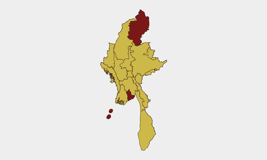
Kachin State (risk 100) remains the epicenter of conflict, driven by entrenched opposition-group presence, ongoing military operations, and restricted humanitarian access. Yangon (92.5) poses elevated risk due to urban security incidents, digital surveillance, and organized crime networks; corporate and expatriate presence there amplifies duty-of-care exposure. Shan, Tanintharyi, and Sagaing regions (all 70) experience lower-intensity but persistent clashes, narcotics trafficking, and armed-group activity that constrain supply chains and movement. All twelve tracked sub-national zones register significant risk; no region qualifies as secure.
How GeoBit Would Assist
Intel Sweep & OSINT Fusion would provide multi-language, real-time event detection across conflict feeds, social media, and NGO reporting to close the 24–48-hour reporting lag and flag incidents before mainstream outlets. AOI Monitoring & Early Warning targeted at Kachin, Yangon, and Shan State would enable persistent watch for military operations, displacement, and armed-group movements, with automated alerts on threshold changes. Battle Mapping & Force Structure analysis, combined with Satellite & Imagery review, would track junta redeployments and opposition-group staging; Routing & Network Analysis would identify safe corridors and pinch points for staff movement and asset protection in high-risk zones.
7-Day Outlook
No major escalation is anticipated in the coming week; the conflict is expected to remain at current operational tempo with localized clashes and humanitarian pressures. Reporting delays will likely persist, limiting visibility until late-June and early-July incident details surface in NGO and international media. Organizations with personnel or assets in Kachin, Yangon, or Shan should maintain elevated posture and rely on direct local networks and real-time monitoring for tactical updates.
Highest-Risk Areas — Ranked
| # | State / Region | Risk |
|---|---|---|
| 1 | Kachin State | 100 |
| 2 | Yangon | 92.5 |
| 3 | Tanintharyi Region | 70 |
| 4 | Shan State | 70 |
| 5 | Chin | 70 |
| 6 | Sagaing Region | 70 |
| 7 | Wa State (Northern Region) | 70 |
| 8 | Magway | 70 |
| 9 | Mandalay | 70 |
| 10 | Rakhine | 70 |
| 11 | Ayeyarwady | 70 |
| 12 | Naypyitaw Union Territory | 70 |
Sources
Previous Daily Briefs
A new Myanmar brief is written every day — each with its own risk map and downloadable CSV. Here's the last week; use the calendar to go further back.
📅 Browse every day by calendar →
Highlighted days have a brief. Tap a day for that day's map & analysis, or “csv” for that day's dataset ($5).