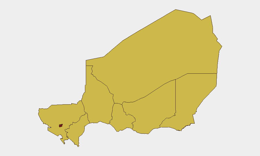
Situation Summary
Niger maintains a composite threat score of 100, ranking 9th globally, with activity concentrated in Niamey and peripheral regions. Recent signals indicate elevated tension between Nigerian state actors and regional/international entities, including military posturing, investigative actions, and public statements spanning 2–4 July. The current trajectory reflects sustained institutional friction rather than imminent mass-casualty or territorial threat, though the frequency and diversity of event types warrant close monitoring for escalation.
Key Developments
Data Limitation: GeoBit's live web research capability has not returned credible, timestamped incident reports for Niger dated 3–4 July 2026. Event signals in the platform (listed above) reference Nigerian actors, scholars, judges, and UNICEF, but lack specific geographic anchoring, casualty counts, or operational detail required for actionable threat updates. Regional confusion between Niger and Nigeria in open-source feeds has prevented reliable incident corroboration. Recommendation: Cross-reference GeoBit event signals against dedicated intelligence platforms (Crisis24, GardaWorld, ACLED) and official Niger government / diplomatic advisories before operationalizing tactical response.
Highest-Risk Areas
Niamey (risk score 100) stands as the sole critical-risk locus, reflecting capital-city concentration of state institutions, media, and diplomatic presence—the likely epicenter of recent investigative, detention, and public-statement activity. The seven peripheral regions (Agadez, Zinder, Diffa, Tillabéri, Tahoua, Dosso, Maradi) are equally ranked at risk score 70, indicating endemic sub-national instability—historically driven by armed-group infiltration, banditry, and intercommunal conflict—but not currently flagged as acute flashpoints by the 4 July signal set. Risk escalation from periphery to capital would signal broader state fragility; containment in Niamey suggests factional or procedural disputes.
How GeoBit Would Assist
Corporate teams should deploy AOI (Area-of-Interest) Monitoring & Early Warning on Niamey, Tillabéri, and Diffa to detect emerging flashpoints before escalation; Network & Actor Analysis to map the Nigerian state entities and individuals cited in recent events; and multi-language OSINT (X/Twitter, Telegram, regional media) to capture French and Arabic reporting ahead of English-language outlets. Routing & Network Analysis enables contingency-path planning for staff in Niamey and northern regions should access corridors degrade. Real-time Sentiment & Temporal Analysis across French-language security sources will flag sharp shifts in official rhetoric or military deployment signals.
7-Day Outlook
Near-term risk is expected to remain elevated but contained within institutional/diplomatic channels; mass violence or military coup indicators are not present in current signals. However, the density of investigative, detention, and threatening actions in a 3-day window suggests factional pressure—watch for rapid hardening of public statements, military movements, or border incidents by 7–10 July. Staff in Niamey should maintain heightened situational awareness and contingency readiness; peripheral-region teams face chronic (not acute) threat.
Highest-Risk Areas — Ranked
| # | State / Region | Risk |
|---|---|---|
| 1 | Niamey | 100 |
| 2 | Agadez Region | 70 |
| 3 | Zinder Region | 70 |
| 4 | Diffa Region | 70 |
| 5 | Tillabéri Region | 70 |
| 6 | Tahoua Region | 70 |
| 7 | Dosso Region | 70 |
| 8 | Maradi Region | 70 |
Sources
Previous Daily Briefs
A new Niger brief is written every day — each with its own risk map and downloadable CSV. Here's the last week; use the calendar to go further back.
📅 Browse every day by calendar →
Highlighted days have a brief. Tap a day for that day's map & analysis, or “csv” for that day's dataset ($5).