Situation Summary
Palau remains in a stable security state with no verified incidents or disruptions reported in the last 24–48 hours (August 15–16, 2026). Port and airport operations continue normally, and no new emergency alerts, curfews, or travel-guidance changes have been issued. The nation's composite threat score of 2 places it at #189 globally, reflecting a low baseline risk environment, though ongoing regional geopolitical tensions—particularly surrounding Chinese military activity and Taiwan's participation in the Pacific Islands Forum later this month—warrant continued monitoring of the strategic context.
Key Developments
No verified security, civil-unrest, crime, political-instability, or infrastructure-disruption incidents have been reported in Palau within the last 24–48 hours (August 15–16, 2026). Recent regional security briefs covering Micronesia confirm normal operations across the nation's transport and administrative infrastructure. The most recent structured update, dated August 12, reported no active security events and normal port/airport function; no new developments have superseded this assessment in the current 24–48-hour window.
*Background context (not current developments):* Earlier reporting (August 12) documented landslides triggered by heavy rainfall at a U.S. defense radar construction site in Ngaraard State; work resumed after investigation. Media accounts from August 10–13 reference Palau's political leadership commenting on Chinese missile tests and regional strategic positioning, but these are political statements rather than new incidents on Palauan soil. Chinese research-vessel incursions cited in recent commentary refer to events in May and earlier years, not August 15–16.
Highest-Risk Areas
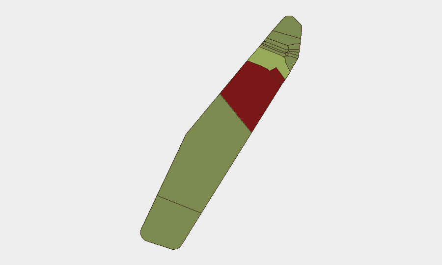
Peleliu (risk 92) and Angaur (risk 88) are the two highest-risk states, significantly above the national average, though the specific drivers of these elevated scores—whether maritime security, infrastructure vulnerability, or other factors—require sector-specific investigation. Koror (risk 45), Palau's largest urban and commercial center, carries moderate risk consistent with population density and economic activity concentration. The remaining nine states score between 22 and 35, indicating dispersed lower-level risk; this distribution suggests that risk concentration is geographic rather than systemic nationwide, and that duty-of-care teams should prioritize asset and personnel safeguards in Peleliu and Angaur above all other locations.
How GeoBit Would Assist
Teams with personnel or assets in Palau would benefit from persistent Area-of-Interest (AOI) Monitoring & Early Warning focused on Peleliu and Angaur to detect emerging incidents in real time, coupled with Intel Sweep and multi-language OSINT (X/Twitter, Telegram, regional news) to capture early signals of unrest, maritime activity, or infrastructure disruption before they escalate. Maritime & Aviation Tracking combined with GIS & Spatial Analysis would enable monitoring of irregular vessel movements and construction or logistical changes at the Ngaraard defense site, reducing exposure to secondary disruptions.
7-Day Outlook
No acute threat indicators are present for the next seven days. However, the Pacific Islands Forum meeting scheduled for later in August—which will include Taiwan's participation—may elevate regional diplomatic activity and potential for protest or political messaging in Koror; security teams should monitor Koror-based media and social channels for signs of planned demonstrations or civil gatherings. Routine monitoring of weather forecasts remains prudent given recent landslide activity in Ngaraard following heavy rainfall.
Highest-Risk Areas — Ranked
| # | State / Region | Risk |
|---|---|---|
| 1 | Peleliu | 92 |
| 2 | Angaur | 88 |
| 3 | Koror | 45 |
| 4 | Melekeok | 35 |
| 5 | Airai | 32 |
| 6 | Ngatpang | 28 |
| 7 | Ngeremlengui | 26 |
| 8 | Ngaraard | 25 |
| 9 | Ngardmau | 24 |
| 10 | Aimeliik | 23 |
| 11 | Ngiwal | 22 |
| 12 | Ngchesar | 21 |
Sources
Previous Daily Briefs
A new Palau brief is written every day — each with its own risk map and downloadable CSV. Here's the last week; use the calendar to go further back.
- August 14, 2026
- August 12, 2026
- August 10, 2026
- August 8, 2026
- August 6, 2026
- August 5, 2026
- August 4, 2026
📅 Browse every day by calendar →
Highlighted days have a brief. Tap a day for that day's map & analysis, or “csv” for that day's dataset ($5).
Atlas — our AI intelligence desk — emails them this snapshot personally. Nothing else, no list.