Situation Summary
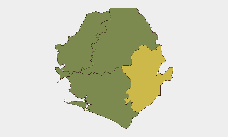
Sierra Leone remains a lower-tier global security concern (ranked #125 globally, composite threat score 6) with concentrated risk in the Eastern Province, where border instability and displacement pressures from Guinea persist. The Western Area (Freetown and immediate surroundings) carries secondary but material risk, driven by urban crime and political volatility. As of 15 July, no acute security deterioration has been reported in the last 24–48 hours; however, planned ECOWAS summit logistics and recent cross-border diplomatic friction warrant close monitoring of airports and official gatherings through mid-July.
Key Developments
- Liberia–Sierra Leone diplomatic statement (14 July): Liberia issued a public statement regarding Sierra Leone; nature and specificity remain unclear from available summary data. Monitor official diplomatic channels and regional media for escalation indicators or trade/border implications.
- Multiple arrest/detention incidents involving New York and Liberia (14 July): Sierra Leone authorities and Army personnel conducted arrests with apparent cross-border or transnational dimensions involving New York and Liberian parties. Exact charges, locations, and operational context require clarification; confirm whether incidents occurred in Freetown, provincial towns, or border regions.
- ECOWAS summit security measures (16–19 July planned): Lungi International Airport cargo terminal closure scheduled 17–19 July for ECOWAS summit logistics. Expect heightened security checkpoints, route congestion, and potential delays for corporate/supply movements in and out of Freetown; plan travel accordingly.
- Yenga (Kailahun District) displacement ongoing: Long-standing cross-border tension with Guinea continues to drive low-level displacement in the Eastern Province. No acute new incident reported in the last 48 hours, but the area remains a monitoring priority for humanitarian and personnel-safety purposes.
- No confirmed incident data for Northern, North West, or Southern Provinces (last 48h): Risk rankings for these regions stand at zero; no security events or developments reported in the reporting window.
Highest-Risk Areas
Eastern Province (risk score 68) dominates the threat picture and reflects Guinea–Sierra Leone border instability, long-running displacement (particularly in Kailahun District around Yenga), and weak state capacity in remote areas. Western Area (risk score 35) encompasses Freetown and Lungi; risk here is primarily driven by urban street crime, political tensions, and infrastructure bottlenecks (airports, ports) where crowds and checkpoints create vulnerability windows. The remaining three provinces register zero risk in current GeoBit tracking, reflecting relative stability and lower event density; however, absence of tracked events does not guarantee security—routine due diligence is advised for any operation in remote locations.
How GeoBit Would Assist
A corporate security team with operations or personnel in Sierra Leone should deploy Area-of-Interest Monitoring & Early Warning on Freetown (Western Area) and Kailahun/Yenga (Eastern Province) to catch border incidents, displacement surges, or security-force activity in near real-time. OSINT fusion (X/Twitter, local media, and regional news) combined with entity and sentiment analysis on government, ECOWAS, and diplomatic statements will clarify the intent and scope of recent Liberia–Sierra Leone and arrest-related developments. GIS & Spatial Analysis supports alternative routing and journey planning for supply chains or personnel movement during the ECOWAS summit window (16–19 July).
7-Day Outlook
No acute escalation is forecast for the next seven days; however, the ECOWAS summit (16–19 July) will create temporary congestion, security checkpoints, and administrative friction in Freetown and at Lungi Airport. Cross-border tension with Guinea is expected to remain low-level and localized to the Eastern Province. Continued monitoring of diplomatic statements between Freetown and Monrovia is warranted to rule out trade or consular disruption.
Highest-Risk Areas — Ranked
| # | State / Region | Risk |
|---|---|---|
| 1 | Eastern Province | 68 |
| 2 | Western Area | 35 |
| 3 | North West Province, Sierra Leone | 0 |
| 4 | Northern Province, Sierra Leone | 0 |
| 5 | Southern Province, Sierra Leone | 0 |
Sources
Previous Daily Briefs
A new Sierra Leone brief is written every day — each with its own risk map and downloadable CSV. Here's the last week; use the calendar to go further back.
📅 Browse every day by calendar →
Highlighted days have a brief. Tap a day for that day's map & analysis, or “csv” for that day's dataset ($5).
Atlas — our AI intelligence desk — emails them this snapshot personally. Nothing else, no list.