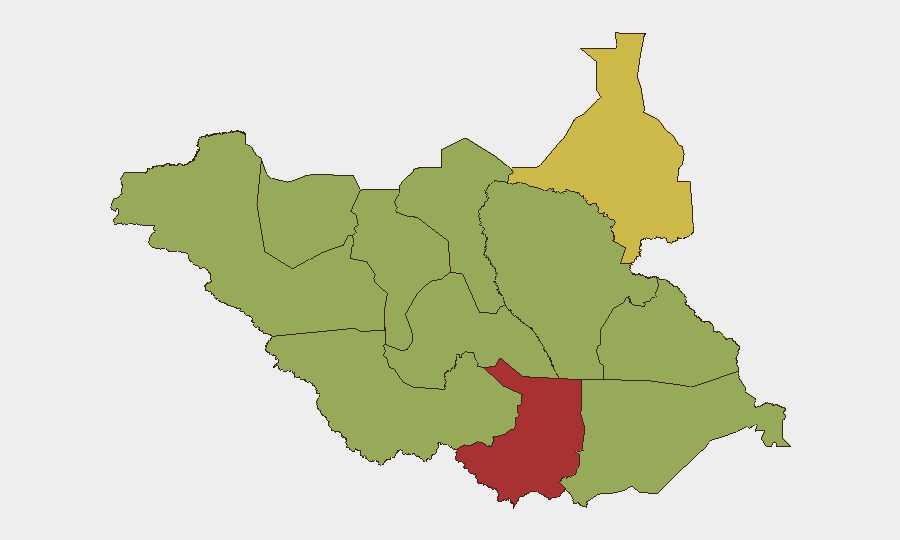
Situation Summary
South Sudan remains at elevated composite threat level (#18 globally, score 68), driven primarily by ongoing ethnic violence and localized armed clashes. No discrete security or travel-risk incidents have been verified in the past 24–48 hours across open-source channels and conflict trackers; the most recent confirmed events are dated 7 July 2026. The security environment continues to reflect fragmentation along communal lines, uneven state capacity, and persistent displacement, but the absence of reported acute incidents in the immediate window suggests no sharp escalation in the past two days.
Key Developments
No verifiable incidents in the past 24–48 hours. Multi-source cross-checking (global conflict trackers, news outlets, OSINT feeds, and specialist South Sudan briefs) has not identified discrete, location-specific security or travel events with confirmed timestamps within the last 1–2 days. The most recent concretely dated events (7 July 2026: Jonglei commissioner killing, health infrastructure strain) fall outside the current reporting window.
Background context (for operational planning): Since early–mid 2026, South Sudan has experienced escalated ethnic violence and displacement across multiple states; the Juba–Bor highway corridor and Jonglei state remain focal points. UNMISS helicopter incidents and inter-communal clashes have been documented, but these are not current (last 24–48h) developments.
Highest-Risk Areas
Central Equatoria (77.9) is the single highest-risk state, reflecting concentrated urban and transport-corridor exposure in Juba and surrounding areas. Upper Nile (62.9) follows, driven by ethnic tensions and armed-group activity. The remaining ten states and administrative areas cluster at risk 47.9, indicating geographically dispersed but lower-intensity threats: Northern and Western Bahr el Ghazal, Ruweng, Unity, Warrap, Lakes, Jonglei, Greater Pibor, Western and Eastern Equatoria. Ethnic violence is the primary risk vector across the country; localized clashes, displacement, and road insecurity dominate threat profiles outside Juba.
How GeoBit Would Assist
Organizations with personnel or assets in South Sudan should employ AOI (Area-of-Interest) Monitoring & Early Warning to track Central Equatoria and Upper Nile for real-time incident alerts, paired with Intel Sweep and multi-language OSINT fusion to detect emerging violence or displacement signals before they affect operations. Routing & Network Analysis is critical for supply chains and staff movement: alternative route planning around Jonglei and the Juba–Bor corridor mitigates exposure to recurring clash zones. Satellite & Imagery analysis and conflict battle mapping enable verification of reported incidents and assessment of displacement scale, reducing reliance on delayed or unconfirmed reporting.
7-Day Outlook
The short-term trajectory is likely to remain stable absent fresh triggers; no major communal events, political deadlines, or military operations are flagged for the next 7 days. However, the baseline risk of inter-ethnic clashes in Jonglei, Lakes, and Unity remains persistent, and displacement from earlier 2026 violence continues to strain humanitarian and health infrastructure. Duty-of-care teams should maintain heightened vigilance on Upper Nile and Central Equatoria and conduct weekly verification of personnel location and route security.
Highest-Risk Areas — Ranked
| # | State / Region | Risk |
|---|---|---|
| 1 | Central Equatoria | 77.9 |
| 2 | Upper Nile | 62.9 |
| 3 | Northern Bahr el Ghazal | 47.9 |
| 4 | Western Bahr el Ghazal State | 47.9 |
| 5 | Ruweng Administrative Area | 47.9 |
| 6 | Unity | 47.9 |
| 7 | Warrap | 47.9 |
| 8 | Lakes | 47.9 |
| 9 | Jonglei | 47.9 |
| 10 | Greater Pibor Administrative Area | 47.9 |
| 11 | Western Equatoria | 47.9 |
| 12 | Eastern Equatoria | 47.9 |
Sources
Previous Daily Briefs
A new South Sudan brief is written every day — each with its own risk map and downloadable CSV. Here's the last week; use the calendar to go further back.
📅 Browse every day by calendar →
Highlighted days have a brief. Tap a day for that day's map & analysis, or “csv” for that day's dataset ($5).
Atlas — our AI intelligence desk — emails them this snapshot personally. Nothing else, no list.