Situation Summary
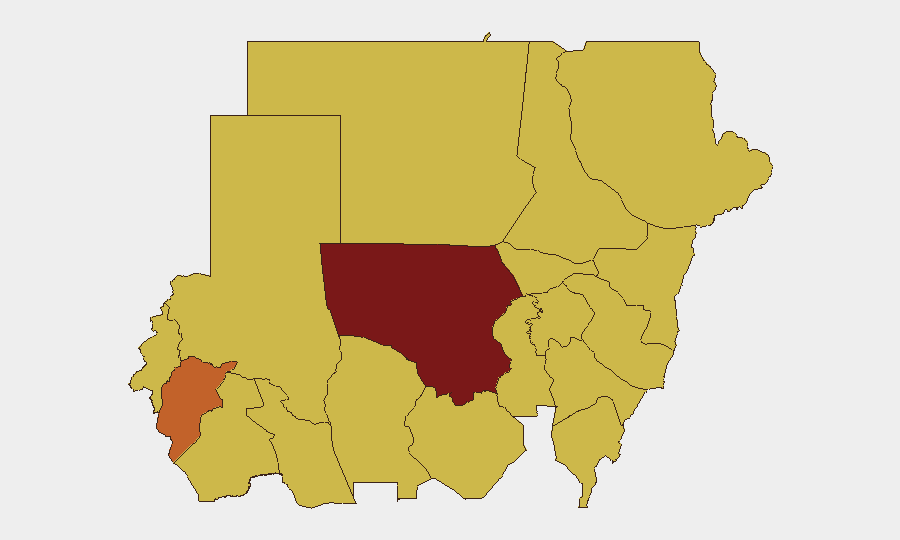
Sudan remains in active civil war with a composite threat score of 100, driven by ongoing conventional military operations involving government and non-state armed groups across multiple regions. North Kordofan State presents the highest sub-national risk (100), followed by Central Darfur and Kassala states, reflecting concentrated fighting and humanitarian deterioration. International actors including the Arab League and Amnesty International have issued recent statements and threats regarding Sudan's conduct, signaling sustained diplomatic pressure alongside military operations. The security environment remains volatile with no indication of de-escalation.
Key Developments
- 2026-07-08 · El Obeid/Kordofan Region: Conventional military force incidents reported involving lawyer and civilian casualties, with separate army operations ongoing. UN human-rights bodies have flagged emergency conditions in El Obeid amid reported intensification of fighting and humanitarian catastrophe risk, though precise 24-hour incident timestamps are unclear from available reporting.
- 2026-07-08 · National Level: Sudan issued a threat statement; Arab League made a public statement regarding Sudan; Egypt issued a separate public statement. These diplomatic moves suggest escalating regional concern over Sudan's trajectory.
- 2026-07-07 · Darfur Region: Fighter forces occupied territory in Darfur; concurrent disapproval statement issued by Sudan against military actors, indicating internal command-and-control friction or contested operations.
- 2026-07-08 · National Level: Amnesty International and separate rights groups issued threats/disapproval regarding Sudan's conduct, consistent with documented civilian casualty concerns and alleged law-of-war violations.
- 2026-07-06 · National Level: Police officer arrest/detention reported; underlying cause and context unclear from signal data, but suggests domestic security apparatus activity.
- 2026-07-07 · National/Student Level: Public statement issued by student actor(s), indicating potential domestic unrest or protest activity alongside military operations.
Highest-Risk Areas
North Kordofan State dominates the risk profile (score 100) and is the primary driver of Sudan's global #8 ranking. Central Darfur, Kassala, Blue Nile, and multiple other states cluster at scores 70–73.5, reflecting active territorial control contests, humanitarian access breakdowns, and densely tracked incident activity. Kordofan's pre-eminence reflects both conventional military force concentration and civilian impact severity. River Nile State, Al Khartum (capital), and Aj Jazira state present elevated risk despite proximity to administrative centers, indicating that geographic proximity to power does not insulate areas from conflict spread.
How GeoBit Would Assist
Security teams should deploy AOI Monitoring & Early Warning on North Kordofan, Central Darfur, and Kassala states to receive real-time alerts on force movements and incident escalation. Conflict & Military battle mapping and force-structure tracking will provide situational clarity on armed-group disposition and likely next operations. OSINT fusion (X/Twitter, Telegram, multi-language search, entity extraction) will accelerate detection of civilian impact, displacement, and access-denial signals that precede humanitarian crises affecting duty-of-care obligations.
7-Day Outlook
Conventional military operations in North Kordofan and Darfur are likely to persist or intensify given the absence of negotiated ceasefires and current diplomatic pressure without enforcement mechanisms. Humanitarian access and civilian casualty risk will remain acute. Organizations with personnel or assets in Kordofan, Darfur, or capital-area states should expect further localized disruption and heightened security incident probability over the coming week.
Highest-Risk Areas — Ranked
| # | State / Region | Risk |
|---|---|---|
| 1 | North Kordofan State | 100 |
| 2 | Central Darfur State | 73 |
| 3 | Kassala State | 70.5 |
| 4 | Blue Nile | 70 |
| 5 | River Nile State | 70 |
| 6 | Al Khartum | 70 |
| 7 | Aj Jazira | 70 |
| 8 | Red Sea State | 70 |
| 9 | Al Qadarif State | 70 |
| 10 | Sennar State | 70 |
| 11 | South Darfur State | 70 |
| 12 | West Kurdufan State | 70 |
Sources
Previous Daily Briefs
A new Sudan brief is written every day — each with its own risk map and downloadable CSV. Here's the last week; use the calendar to go further back.
📅 Browse every day by calendar →
Highlighted days have a brief. Tap a day for that day's map & analysis, or “csv” for that day's dataset ($5).
Atlas — our AI intelligence desk — emails them this snapshot personally. Nothing else, no list.