Situation Summary
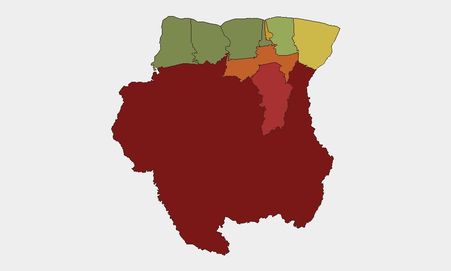
Suriname remains a low-intensity threat environment (global rank #171, composite score 4) with no active armed conflict or organized political instability tracked as of 14 August 2026. Crime—including interpersonal violence, armed robbery, and road safety incidents—constitutes the principal near-term risk to corporate personnel and assets. Regional variation is pronounced: interior and border zones (Sipaliwini, Brokopondo, Para) carry substantially elevated risk relative to coastal urban centers, reflecting illicit trafficking networks, limited state presence, and informal settlement dynamics.
Key Developments
- Fatal traffic collision, Santopolderweg – 13 August 2026. A female pedestrian was fatally struck by a car during an overtaking maneuver in the morning of 13 August. Emergency services responded; police opened a formal investigation and cordoned the incident site. Road safety remains a material risk factor for personnel transit in Suriname.
- MV Canawaima cross-border ferry sailing ban effective 14 August 2026. Suriname's Maritime Authority (MAS) imposed a sailing suspension on the Canawaima ferry (Suriname–Guyana route) effective 00:00 on 14 August 2026, contingent on unmet safety-compliance deadlines. The ban affects cross-border travel and logistics connectivity with Guyana pending remediation of safety deficiencies.
Highest-Risk Areas
Sipaliwini district (risk score 92) ranks as Suriname's highest-risk zone, driven by remoteness, limited law-enforcement capacity, and proximity to illicit drug-trafficking corridors linking Brazil and the Caribbean. Brokopondo (78) and Para (74) follow, reflecting similar interior vulnerabilities and informal-settlement dynamics. Paramaribo (71), despite its status as the capital and commercial hub, carries elevated urban-crime risk, including armed robbery and interpersonal violence. Coastal districts (Coronie, Nickerie) remain comparatively lower-risk. Corporate assets and personnel in the interior and greater Paramaribo metropolitan area warrant heightened due-diligence protocols.
How GeoBit Would Assist
Intel Sweep and X/Twitter OSINT would provide real-time event capture and social-signal corroboration across Suriname's major urban centers and border zones, enabling rapid confirmation of crime, unrest, or infrastructure disruptions. AOI Monitoring & Early Warning on Sipaliwini, Brokopondo, and Paramaribo would furnish persistent alerting for trafficking activity, protests, or security incidents affecting corporate operations. Alternative Route & Network Analysis would support contingency planning for personnel movement and supply chains, particularly in light of the current ferry disruption and persistent road-safety incidents.
7-Day Outlook
No significant escalation in political or organized-violence risk is anticipated over the next seven days. Road safety, transnational-smuggling activity in border districts, and urban crime (robbery, assault) will remain the principal threat drivers. The MV Canawaima sailing suspension will likely remain in effect through mid-week unless Maritime Authority safety directives are rapidly satisfied, maintaining pressure on Suriname–Guyana logistics and cross-border personnel movement.
Highest-Risk Areas — Ranked
| # | State / Region | Risk |
|---|---|---|
| 1 | Sipaliwini | 92 |
| 2 | Brokopondo | 78 |
| 3 | Para | 74 |
| 4 | Paramaribo | 71 |
| 5 | Marowijne | 68 |
| 6 | Commewijne | 42 |
| 7 | Wanica | 38 |
| 8 | Saramacca | 29 |
| 9 | Coronie | 12 |
| 10 | Nickerie | 8 |
Sources
Previous Daily Briefs
A new Suriname brief is written every day — each with its own risk map and downloadable CSV. Here's the last week; use the calendar to go further back.
- August 12, 2026
- August 10, 2026
- August 8, 2026
- August 6, 2026
- August 5, 2026
- August 4, 2026
- August 3, 2026
📅 Browse every day by calendar →
Highlighted days have a brief. Tap a day for that day's map & analysis, or “csv” for that day's dataset ($5).
Atlas — our AI intelligence desk — emails them this snapshot personally. Nothing else, no list.