Situation Summary
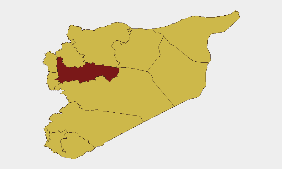
Syria remains in a fragile state of contested governance and intermittent cross-border tensions, ranking #19 globally in composite threat (score 91/156 tracked events). Recent diplomatic disapprovals and Israeli-related incidents signal elevated regional friction, particularly affecting southern and western regions. Hama Governorate dominates the risk profile at 93.8, substantially above all other sub-national areas, while Damascus and border zones maintain elevated but secondary risk levels. Current trajectory reflects chronic instability with periodic escalation triggers tied to Israeli activity and inter-state disagreements.
Key Developments
- 2026-07-02: Italy–Romania diplomatic threat issued; regional implications for Syria coordination unclear pending detail clarification.
- 2026-07-01: Syria formally disapproved Israeli actions; second such disapproval within 24 hours (also 2026-06-30), indicating sustained rhetorical escalation over southern border incidents.
- 2026-07-02: Government ministry released public statement; subject and implications require corroboration but suggests official positioning on an active issue.
- 2026-06-30: Galilee-based demand directed at schools; appears to reflect Israeli-side enforcement or administrative action in territory bordering Syria, with secondary spillover-risk implications.
- 2026-06-30: Damascus authorities initiated investigation of SANA (Syrian Arab News Agency), suggesting internal state-media or information-control friction.
- 2026-06-30: Jordan and Saudi statements of disapproval toward Israeli and Syrian actors respectively; multi-state concern convergence indicates widening regional concern over southern conduct.
- 2026-06-30: Government forces rejection of an unspecified demand; suggests resistance to external or internal pressure, context pending.
*(Note: Live web corroboration limited to single Al Jazeera reference noting Israeli assaults in southern Syria and violent confrontations involving Assad supporters; specific dates and actor details require secondary confirmation.)*
Highest-Risk Areas
Hama Governorate (93.8) is the clear outlier and driver of national risk, a 43% elevation above the second-ranked Damascus (65.2). This reflects Hama's history as a flashpoint for opposition activity, sectarian tension, and regime-security operations. The remaining ten governorates cluster tightly (63.8), indicating either systematic data-collection parity or a genuine secondary tier of distributed, chronic risk. Damascus, As-Suweida, Lattakia, Tartus, and the UNDOF zone warrant focused attention for personnel and asset protection; proximity to Israeli territory, sectarian composition, and UN monitoring presence make these zones sensitive to both localized incident and cross-border escalation. Border regions (Dar'a, Idleb, Al-Quneitra, northern Aleppo) remain vulnerable to spillover from Israeli activity and Turkish-Kurdish dynamics.
How GeoBit Would Assist
Teams with personnel or assets in Syria should deploy AOI Monitoring & Early Warning on Hama, Damascus, and southern border zones to catch rapid escalation signals; pair with OSINT Fusion (X/Telegram/YouTube intelligence) to track real-time actor positioning and rhetoric. Conflict & Military mapping combined with satellite/imagery analysis enables tracking of force movement and security-operation timing in high-risk governorates. Routing & Network Analysis supports alternative-journey planning for staff movement in Damascus and Lattakia, mitigating exposure to incident zones. Regular Intel Sweep feeds will surface policy changes, sanctions, or regime actions affecting business continuity.
7-Day Outlook
Israeli–Syrian rhetorical and operational tempo appears elevated; expect continued disapprovals and counter-statements over southern incidents without clear de-escalation signal. Hama and border zones will remain primary concern for any operational activity. Regional states (Jordan, Saudi Arabia, Turkey) are monitoring closely, reducing unilateral escalation risk but increasing likelihood of proxy or diplomatic pressure-point shifts.
Highest-Risk Areas — Ranked
| # | State / Region | Risk |
|---|---|---|
| 1 | Hama Governorate | 93.8 |
| 2 | Damascus Governorate | 65.2 |
| 3 | As-Suweida Governorate | 64.3 |
| 4 | Lattakia Governorate | 63.8 |
| 5 | Tartus Governorate | 63.8 |
| 6 | UNDOF | 63.8 |
| 7 | Al-Quneitra Governorate | 63.8 |
| 8 | Dar'a Governorate | 63.8 |
| 9 | Idleb Governorate | 63.8 |
| 10 | Aleppo Governorate | 63.8 |
| 11 | Ar-Raqqa Governorate | 63.8 |
| 12 | Homs Governorate | 63.8 |
Sources
Previous Daily Briefs
A new Syria brief is written every day — each with its own risk map and downloadable CSV. Here's the last week; use the calendar to go further back.
📅 Browse every day by calendar →
Highlighted days have a brief. Tap a day for that day's map & analysis, or “csv” for that day's dataset ($5).