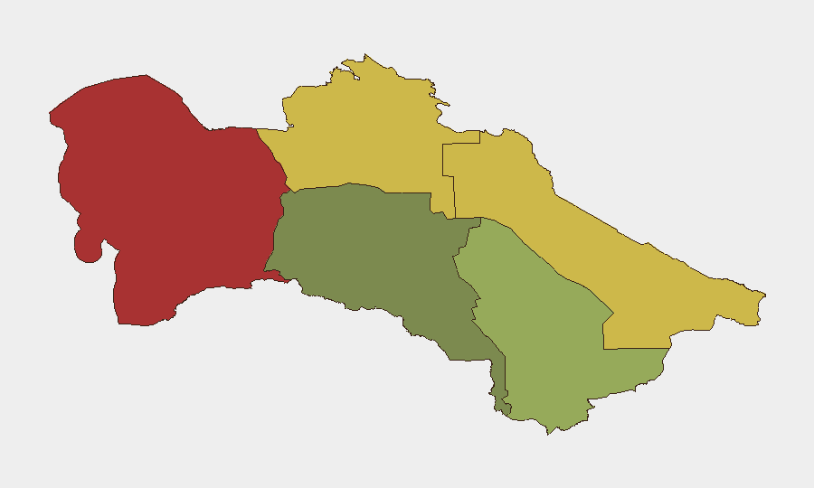
Situation Summary
Turkmenistan remains a low-threat environment at the national level (global rank #184, composite score 3), with no verified security incidents reported in the week of 21–28 September 2026. The country's overall stability is underpinned by centralized state control and limited internal conflict; however, sub-national risk concentrations in the Balkan and Lebap regions warrant targeted monitoring. A minor diplomatic incident involving airspace denial underscores the importance of monitoring aviation and cross-border activity, particularly given regional geopolitical tensions.
Key Developments
- Tehran–Dushanbe flight denied Turkmen airspace transit (24 September 2026): Turkmenistan denied an Iranian airline permission to transit its airspace, forcing the aircraft to return to Tehran. The incident was reported by Iran's Civil Aviation Organization, APA, Iran International, Anadolu Agency, and TodayPress. The underlying cause and diplomatic context remain unclear from available sources.
- No other verified security incidents recorded (21–28 September 2026): Web research identified no corroborated reports of conflict, civil unrest, terrorism, crime, infrastructure failure, or political instability during the reporting window.
Highest-Risk Areas
The Balkan Region (risk 78) and Lebap Region (risk 68) drive the country's sub-national threat profile, followed by Dashoguz (risk 62). These concentrations likely reflect historical instability, border proximity (Balkan and Lebap border Uzbekistan and Afghanistan/Tajikistan), smuggling networks, and sparse state presence in remote areas. Ashgabat City (risk 18) and Ahal Region (risk 35) show substantially lower risk, consistent with capital-city control and relative stability in the south. Organizations with operations or personnel in northern and western regions should maintain enhanced awareness.
How GeoBit Would Assist
Security teams operating in or transiting Turkmenistan should deploy AOI Monitoring & Early Warning on Balkan, Lebap, and Dashoguz regions to detect emerging instability, cross-border movement, or infrastructure disruptions. Aviation & Maritime Tracking combined with multi-language OSINT (including Telegram and regional news feeds) would provide real-time visibility into airspace restrictions, border closures, and official announcements affecting travel and logistics. Routing & Network Analysis can identify alternative transport corridors and supply-chain resilience in the event of localized disruption or diplomatic restrictions.
7-Day Outlook
No escalation in national-level security risk is anticipated over the next seven days. Continued monitoring of the Balkan and Lebap regions for cross-border activity and the Tehran–Dushanbe airspace incident for any follow-on diplomatic or travel restrictions is warranted. The incident itself does not signal broader instability but serves as a reminder that regional geopolitics (Iran–Turkmenistan relations, Taliban resurgence in Afghanistan, Tajik–Uzbek border tensions) can create localized disruptions to commerce and transit.
Highest-Risk Areas — Ranked
| # | State / Region | Risk |
|---|---|---|
| 1 | Balkan Region | 78 |
| 2 | Lebap Region | 68 |
| 3 | Dashoguz Region | 62 |
| 4 | Mary Region | 42 |
| 5 | Ahal Region | 35 |
| 6 | Ashgabat City | 18 |
Sources
Previous Weekly Briefs
A new Turkmenistan brief is written every Monday, covering the week — each with its own risk map and downloadable CSV. Use the calendar to go further back.
- September 21, 2026
- September 14, 2026
- September 7, 2026
- September 3, 2026
- September 2, 2026
- September 1, 2026
- August 31, 2026
📅 Browse past briefs by calendar →
Highlighted days have a brief. Tap a day for that day's map & analysis, or “csv” for that day's dataset ($5).
Atlas — our AI intelligence desk — emails them this snapshot personally. Nothing else, no list.