Situation Summary
The United States faces an elevated composite threat environment (rank #1 globally, score 100) characterized by fragmented security incidents spanning unconventional violence, armed confrontations, territorial disputes, and institutional conflict. Texas, New York, and California present the highest sub-national risk concentrations. The last 48 hours have seen escalating signals including armed engagements in Memphis and Houston, firefighter-involved conventional force in Colorado, judicial rejection of federal authority, and territorial occupation in Maine, indicating a deteriorating security posture across multiple domains.
Key Developments
- 2026-07-08 · Houston, Texas – Small arms combat reported involving Houston and Mexican actors; highest-risk state ongoing.
- 2026-07-08 · National – Representatives issued public statement; timing suggests legislative response to unfolding crisis.
- 2026-07-08 · Federal – Federal judge rejected government action, signaling institutional fracture and rule-of-law strain.
- 2026-07-07 · Maine – Maine actors occupied territory at Chamber; territorial control dispute in eighth-highest-risk state.
- 2026-07-07 · National – Unconventional violence reported via Associated Press; media flagging non-standard attack vectors.
- 2026-07-07 · National – Companies threatened; economic or infrastructure targets potentially signaled.
- 2026-07-06 · Memphis, Tennessee – Small arms combat between National Guard and Memphis actors; direct armed engagement.
- 2026-07-06 · Memphis, Tennessee – Presidential force deployment to Memphis; federal escalation in response to armed confrontation.
- 2026-07-06 · Colorado – Conventional military force deployed against firefighter personnel; unusual inter-agency armed conflict.
Highest-Risk Areas
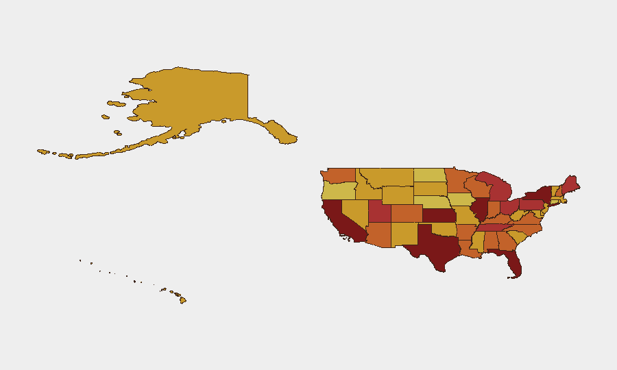
Texas (score 100) and New York (98.2) dominate the risk profile, with Texas showing the most acute active threat density. California (92.7) represents sustained elevated risk across multiple threat vectors. Southern and Midwest states (Tennessee, Kansas, Florida, Illinois) show elevated armed-confrontation signals, while Maine and Ohio indicate emerging territorial and institutional disputes. The concentration of small-arms combat, presidential force deployment, and judicial rejection in high-risk states suggests systemic rather than localized breakdown.
How GeoBit Would Assist
Security teams would deploy AOI Monitoring & Early Warning on Texas, New York, and California with persistent alerting for armed activity, territorial changes, and institutional rejections. Intel Sweep across news, X/Twitter, and Telegram would track public statements by Representatives, media, and law enforcement to detect escalation triggers and coalition shifts. GIS & Spatial Analysis would map armed engagements (Memphis, Houston, Colorado) against infrastructure, corporate presence, and transportation corridors to forecast downstream disruption and identify safe routing alternatives via Routing & Network Analysis.
7-Day Outlook
The confluence of armed engagements, institutional breakdown (federal judge rejection), territorial occupation, and public threat signals suggests heightened risk of cascading incidents through mid-July. Personnel and assets in Texas, New York, and California should anticipate continued volatility, with secondary contagion into adjacent high-risk states (Tennessee, Kansas, Florida) likely if armed engagements expand or federal coordination fractures further. Monitoring for public statements and legislative action will provide early warning of de-escalation or further institutional escalation.
Highest-Risk Areas — Ranked
| # | State / Region | Risk |
|---|---|---|
| 1 | Texas | 100 |
| 2 | New York | 98.2 |
| 3 | California | 92.7 |
| 4 | Kansas | 85.7 |
| 5 | Florida | 81.7 |
| 6 | Illinois | 80 |
| 7 | Utah | 79.1 |
| 8 | Maine | 78.5 |
| 9 | Ohio | 78.5 |
| 10 | Michigan | 77.4 |
| 11 | Pennsylvania | 76.4 |
| 12 | Tennessee | 76.4 |
Sources
Previous Daily Briefs
A new United States brief is written every day — each with its own risk map and downloadable CSV. Here's the last week; use the calendar to go further back.
📅 Browse every day by calendar →
Highlighted days have a brief. Tap a day for that day's map & analysis, or “csv” for that day's dataset ($5).
Atlas — our AI intelligence desk — emails them this snapshot personally. Nothing else, no list.